It’s takes a year to secure the funding for just the engineering work, which includes test layouts (are the BRT lanes on the curb or in the center? Do they operate on New Bern and Edenton or just on one, and if it’s on one, what does the contraflow lane look like, etc.) and an environmental impact statement, including any remediation that needs to be done as a result. There will likely need to be some bridge replacements…there is actually a bridge at the New Bern/Raleigh intersection, whether you notice it or not. Then you get to the full reconstruction of New Bern east of Raleigh, with sidewalks, new utilities, BRT running lanes, traffic signal priority infrastructure, etc. You can’t just throw some paint on a traffic lane and say it’s BRT, there are multiple levels of infrastructure that need to be completely replaced. Not to mention multiple sources of funding (and therefore, reporting) to pay for it all. Add it all up, and four years is a very reasonable timeframe. I’ve seen places where it’s taken twice as long.
Someone close to this explained to me that for more funding to show up, you kind of need to “prove” your region can do good with the money so launching one, successful route here real well would then pave the way for more.
Let’s hope they deliver with flying colors so the rest of the system just falls into place.
For this reason, I think New Bern is the right call. Route 15 is the 2nd busiest bus route in Raleigh, and there is enough room to build dedicated lanes for most of the length without needing lots of new right-of-way.
How will the cost to ride the BRT compare to the cost to ride the GoRaleigh buses? Also, will the GoRaleigh buses cease to operate along the BRT route, or will it be redundant? Pardon my ignorance, as I have never ridden a City bus and have no idea how much it costs. I did see the BRT in Richmond back in November, and was kinda impressed, but did find it awkward how it ran down the middle of the road.
Thanks for sharing. I’m looking forward to this kicking off. New Bern Avenue is an ideal corridor with an existing mix of housing and other land uses, with a lot of opportunities for expanded density. I’d like to see better streetscape, mix of uses, and focus on walking around Wake Med.
I am particularly hoping that phase 1 takes the dedicated lanes past 440, as that where congestion is the worst. Going out to New Hope or even Rogers would be a good step, but going past 540 and into Knightdale should be the end goal.
The southern gateway corridor should be a slam dunk for the next BRT route.
Does anyone know what efforts are being made in coordination with the BRT project in regards to land use and encouraging dense, transit-oriented development along the routes? I’m a bit concerned that this will get left out, especially on the Capital and Western routes.
There is a Western Blvd. corridor study on the way, with both Raleigh and Cary participating. Cary is also working on a study for its new multimodal facility. As for S. Wilmington, the long term plans call for replacing all of those shopping centers in front of Renaissance Park with mixed-use.
Thanks! That’s helpful info. Hope we stick to this timeline.
I had seen the Wilmington plans, but I can’t help but doubt that they’ll be incorporated into the route for BRT, at least for now. There doesn’t seem to have been much if any visible movement in that area aside from the City purchasing the property north of that shopping centre. Nevertheless, I hope I’m wrong. Those plans were very agreeable.
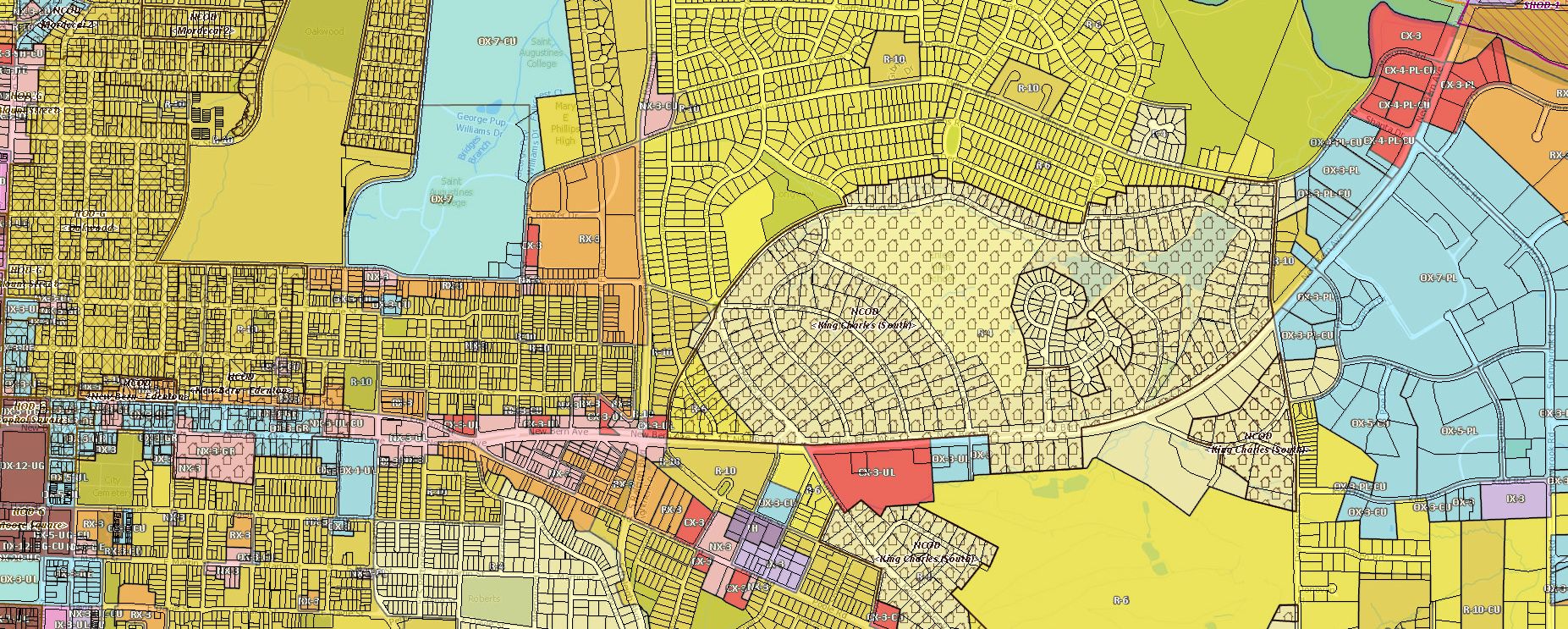
Check out the zoning plus overlays for the New Bern BRT route. Maybe 35% of the area around it has an overlay. The country club sticks out as an interesting land use choice to have next to a BRT line as well.
Here is the general 10 minute walk shed, which I think is a pretty good view of areas that will be effected.
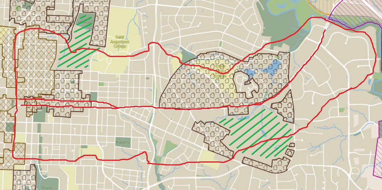
This is a fantastic map! Thanks.
I like geeky graphs like this. I especially like this one because I’m a big walker. It’s not unusual for me to go on 6 mile walks after work with a friend to just shoot the breeze and get the legs moving. As a big walker, I’ve notice that some “6 miles” are more burdensome than other “6 miles”. What I mean about this is that some places entice me to walk more than others. It will be interesting to see how this service is leveraged and which routes are taken by foot from the stops. It’s those routes where we should concentrate on making them more interesting, engaging and intimate for the walker. I know that there are heat maps for some cities that show were walking happens; does Raleigh have such heat maps? If so, it would be interesting to compare before and after.
Not sure if Raleigh’s ArcGIS tools have them (if I had to guess, they probably don’t)…
…but if you combine the maps that they do give you with this free isochronous map tool, it might not be hard to come up with them yourself.
Thanks. I love playing with fun online tools! I don’t usually know what the hell I’m doing, but I have fun nonetheless.
Here’s another one that I found. This one lets you choose your mode of transportation and map it. According to this tool, the amount of walking drops like a lead balloon as you head east from the downtown core.
be careful with Strava results. They’re biased towards people that do marathons and ride in cycle clubs. I bet SE raleigh has really high pedestrian counts but Strava might not be a very popular app in that area.
How cool is the community with BRT routes cancelling plans to convert Blount and Person street to 2-way? This would be required for most of the preferred alternatives. Is it worth the hit to pedestrian safety? They’re also projecting they’ll have to narrow some sidewalks if they implement the most popular alternatives.
The downtown transportation plan also designates certain types of bike facilities on various streets (not on the BRT routes), but provides no funding or requirement to implement. Which means that we’ll be losing existing bike lanes and future options for separated facilities when BRT is implemented, then we’re back to square one for getting funding, public and political support for bike facilities.
The farther we go down this planning path (and watching the GoTriangle folks try to close Blackwell st crossing in Durham to foot traffic) the more I become concerned that the goal is to implement a big transit plan as a vanity project without due concern for how it affects the safety and comfort of pedestrians, especially downtown. A walkable city core is the primary prerequisite of any successful mass transit system.