At the BPAC presentation on Monday, they mentioned that there will be bike parking but I wouldn’t say secure bike parking at this point (I don’t think they’ve evaluated that yet)
3 Likes
On Tuesday, GoRaleigh’s route committee met and discussed the next step towards making the northern (Capital Blvd.) BRT a thing: sending Requests for Proposals to planning and consulting firms to lay out its future route, and see if this BRT service is worth it in the first place.
Remember, this is the last -and most complicated- of the BRT routes that first became a legit thing over half a decade ago. The Capital BRT was going to be a stub that ended near the Greyhound station on Capital Blvd. in the original plan. Recent decisions by the city gave life to the idea to extend it to a more logical place like North Hills or Triangle Town Center, but this means we now have to figure out:

The answer to those concerns are not obvious, right? But neither engineers nor funding agencies can do anything without having those constraints defined. That’s why the city’s doing a major investment study for this last corridor (unlike a simple LPA decision like in the other three BRT corridors).

Is there evidence to support the existence of this extended BRT corridor? Is it physically possible to make it work with the proposed Capital Blvd. redo, especially around the 440 interchange? How long will we have to wait to ride this (if it happens)? Can we afford a two-branch service without breaking it up into phases? Hopefully, we’ll have an answer to all of those questions and more in a little over a year.
5 Likes

One of these routes makes sense to me. The first one if the Midtown Exchange builds up as expected.
Maybe the northern route can be split into two with Capital Blvd towards Wake Forest being a new line.
6 Likes
GoFast! Works for me.
There’s existing plans for 15 minute frequency between downtown and North Hills similar to the second map. Looks like 2023 is the target date.

Given that, I would try to target Triangle Town Center because the Capital route has very high ridership. It would also benefit routes such as the WRX (Wake Forest express route).
4 Likes
My thoughts are to do a branch type double route.
Your main route follows Capital Blvd in exclusive BRT / express lanes with in line stations.
Your branch route leaves Capital around Atlantic and snakes through over to North Hills. This one would probably be mixed traffic but I’d try everything in my power to have exclusive ROW through 440.
2 Likes
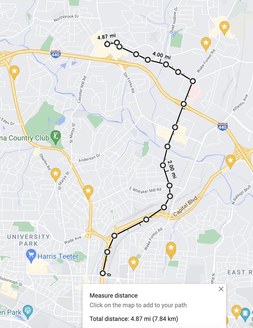
I think @Francisco’s idea of going down Wake Forest Rd. makes more sense than Atlantic Av., since it’s probably closer to denser developments (and riverside park?) that’s proposed to be built along Crabtree Creek. But I like the general idea of using a branched route, too, especially where you push for RoW near 440 (probably along St. Albans Dr.).
In that respect, I think a phased approach makes the most sense. Maybe something like this? Note that you can go into the sidebar on the left to look at different phases as well as engineering/planning challenges.
3 Likes
Yea Wake Forest Rd is probably optimal. My main argument for Atlantic would be the easier ability to have a dedicated guideway and to avoid the 440 interchange.
I think the plan for Atlantic is to include a protected bike lane at some point in the future, so mixing that with BRT may not be possible due to space constraints.
2 Likes
As long as the BRT is running on the median on Capital Blvd. (and that study’s draft results outlined just that), I think that’s unavoidable. Maybe you could get away with it if a bridge or two get redesigned or a bus-only flyover can be built above both highways, but I think it’s going to be tough and expensive either way.
Either way, for the people who don’t actually care about our debates, I think it’s clear that getting a BRT to run through this corridor is anything but straightforward. You may think it’s dumb that we have to do studies on top of studies to make things happen, but the truth is that it actually kinda matters here.
12 Likes
I hope no one is giving you the impression that we think this discussion is dumb!! A little technical at times for a historian, lol, but its interesting to follow along and see how the sausage is made - and why it can take so long.
As to any negative comments, everyone is free to read, skim or skip. Use your freedoms.
3 Likes
Oh yeah no, I think you (and most of y’all who regularly chime in in the transit-related threads)'re totally fine! Sometimes, I just wonder about the people who only check in every once in a while and don’t have the level of curiosity or patience that you do ![]()
I’m just like “the reason it’s slow and complex and hard is right there”.

3 Likes
Either route won’t affect me much at all but going down Atlantic will hit up the apartment complexes at the intersection of Atlantic/East Six Forks. The back part of the apartments are half a mile away. At East Whitaker/Atlantic, the Raleigh Iron works is also going in. Technically it could be accessed regardless of going the Wake Forest Rd route or Atlantic Ave. In either case, I also agree it may be better doing down St. Albans.
I’m not sure how much more dense it would get going down Wake Forest Rd between East Six Forks and East Whitaker. I think it’s possible that it gets more dense but it may be a battle to let development in.
2 Likes
You are 100% right on this. The more you get into the planning and obstacles to overcome the more it can feel like you are a crazy conspiracy person when you talk to the average person who is like, “The city is stupid, why didn’t they just fix it.?”
I remember seeing someone on twitter who heard that New Bern was going to get BRT first, and they said essentially, “It is crazy that they would not start with Capital Blvd? How could they not see that it needs BRT the most!” It was hard to respond without sounding like this.

I ended up saying that New Bern had the second most ridership of all lines now, and the city didn’t need to really effect much traffic at all so planning it was the easiest to start with.
None of this would ever be apparent to ~99% of the people in Raleigh 
10 Likes
On top of the actual design you have ROW negotiations which can take years if owners want to hold on to their land, land surveys, environmental surveys and more!
I always wonder how they even managed to get big projects done back in the day. It’s crazy how much goes into the plan development process.
I’m working on some pedestrian crossing / signal upgrades right now. Pretty straightforward and it still takes 3 years to get to construction.
5 Likes
True, it’s crazy -but I think the reason why is simple: corporations and local governments, alike, could quickly build things in the past because no one had any reason to say otherwise. We’re better than that nowadays, but the red tape is the cost we had to pay to get there.
In other words: it's thanks to history. Click here to see how.
Cost-benefit analyses weren’t used much in the real world until the early-mid 20th century, and public relations as a profession is also younger than you’d think. That means developers had fewer stakeholders to please and less pressure to treat business decisions as a logical, evidence-based science. Combine that with how the flow of information was much less in sync with how things “really” happened before the internet (or TV or radio, even), and I’m sure you can picture how hard it was to hold motivated robber barons accountable. People outside of the direct ecosystem of the transit market didn’t know they could be informed about these issues in the first place, let alone feeling the need to be informed about it or to get involved.
Then there were planners like Robert Moses, the man who treated New York City like his personal savegame of Cities: Skylines. He played a part both in brilliant civic achievements like bringing the UN Headquarters to Manhattan as well as more sinister acts like deliberately bulldozing and isolating minority neighborhoods using highway plans. Even smaller cities could still get away with building cheap bridges that can rip itself apart, for example, because there was no way or motivation for anyone to stop them.
The United States has a history of taking advantage of (and bringing down) workers (and sometimes whole communities of them) from redlining to school districting, and atoning for those mistakes demands equity analyses. Rail giants rigging prices and otherwise acting like monopolies led to antitrust laws that came with tons of safety standards. Pesticides wiping out ecosystems led to, among other things, NEPA’s passage while anger over the teardown of the original New York Penn Station helped bring about the National Historic Preservation Act. …et cetera, et cetera.
TL/DR: The trials and tribulations of the people who came before us, I think, informs the work that has to go into public development. It used to be easy, but then people learned about all the consequences.
4 Likes
The northern BRT route is indeed tricky. Spent a while looking at it and there’s no obvious “best solution”.
You do obviously want buses on Six Forks, Wake Forest/Falls of Neuse, and Capital Blvd, all to use the BRT “spine.” Capital Blvd is a very high ridership route (for Raleigh) so you probably want that one to have the fastest route possible by staying more-or-less on Capital Blvd. But where do you start to peel off the other two routes?
Just following Wake Forest, and split at the Six Forks intersection, is the obvious choice. Splitting at St Albans is another possibility, although it’s not my preference because while it may serve the Midtown area better, it would make the Six Forks bus route slower.
Problem is, this leaves the area between Atlantic and Capital, which has just over 1000 units (apartments and condos) at least 3/4 mile walk away from any bus service. So maybe you do want something to run along Atlantic after all? Should we route one of the other two routes along Atlantic ITB? Which one? Do we need to consider a full scale Atlantic Avenue bus route?
No easy answer.
3 Likes
I think, yes. Forcing both of these areas together just because they’re fairly close I don’t think makes sense.
2 Likes
Another option would be to forget Atlantic as a bus route. Sooner or later, the S-line will get commuter trains, and that runs parallel to Atlantic, never more than 1000ft away.
On the other hand that might make a bus route more important, to fill in the gaps between stations?
5 Likes
Just a thought. Circular neighborhood trolleys. Make them open air and colorful and stop anywhere safe on the route.
A regular bus will just not have the appeal to get people to use them. It’s what I want to happen to connect Hillsborough Street District/Village to Downtown.
Of course you will need a road diet to lower the speed limits on these routes as well.
6 Likes