Love this and thanks for the effort! What this view doesn’t capture is Smokey Hollow (I realize that was mentioned) and Fairweather (45 units) as well as S. Street condos if that ever takes off.
Edit: as I caught up with the thread I realize the additional shots and edits cover some of that. I just love that we have so much going on!
Man that’s another great picture and I agree. Huge skyline changes! Doubles the core easy. Hope you don’t mind if I continue to share your awesome pictures.
This is a fantastic image. It really captures how much opportunity there is on the north side of DT. Whether it’s a stadium district or a new complex of government and private towers, that whole area around the Halifax Mall could really be so different in the future.
All those free standing parking decks are just parking lots in 3D. Tear those down and replace them with much taller residential structures and you can capture a couple of months of growth right there.
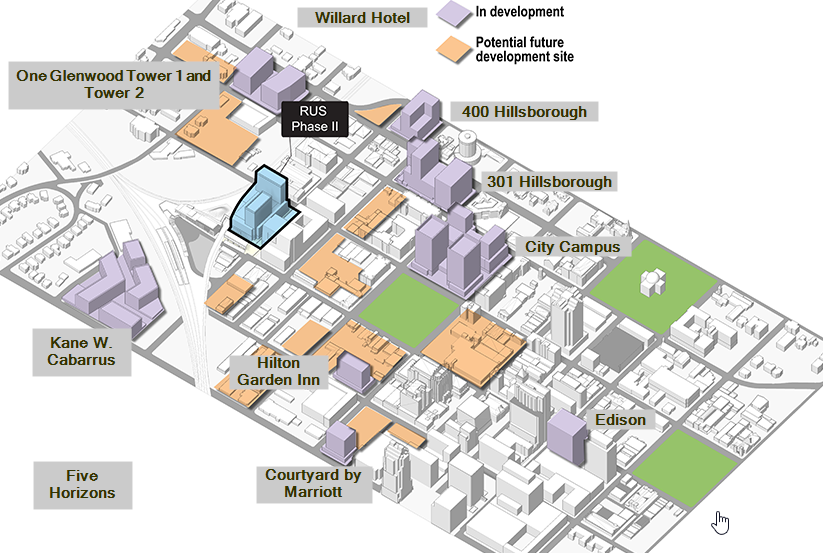
The Raleigh Union Station Bus project had an interesting diagram with new development, to which I’ve added labels. At a year old, this diagram is already missing lots of new stuff.
However, of the ‘in development’ purple buildings, only one of them has started (One Glenwood Tower 1). You can pretty much double this diagram if you include the new projects since this diagram was created.
I found a decent free floor plan renderer, so there might be good free ones for 3-D rendering if you are into trying that stuff on your own. I love all kinds of maps and topo stuff but never got far into making them myself.
I was hoping to tap your excitement and get a freebie myself. I already do one half-a$$ google maps development page (Will doing another) that goes back to 1996.
KEEP GOING!!! If I may suggest- when you finish all the existing and currently under-construction buildings, you should make the proposed projects a bright neon green or something- to really highlight what the future might hold. Thank you for this!!!