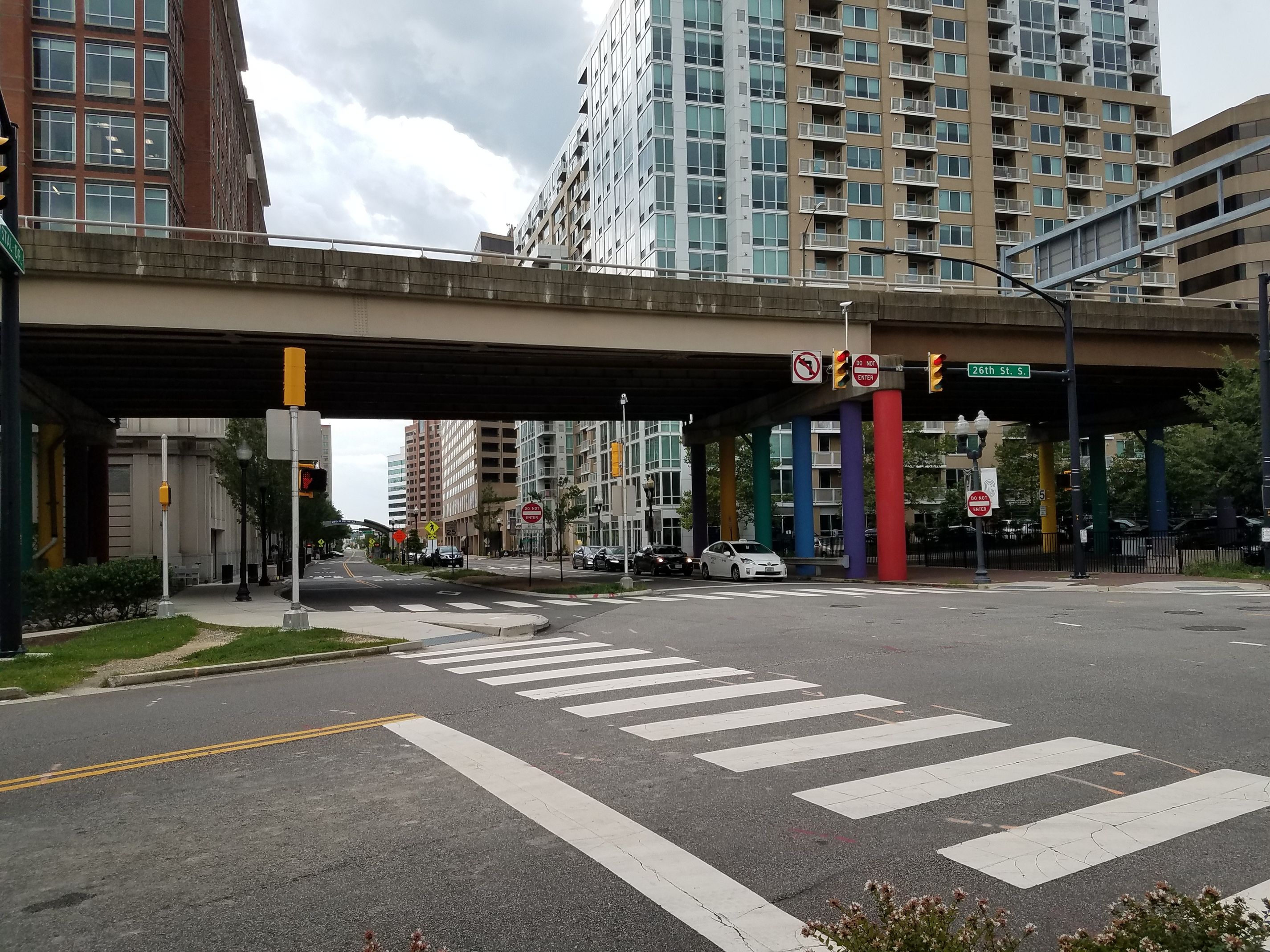
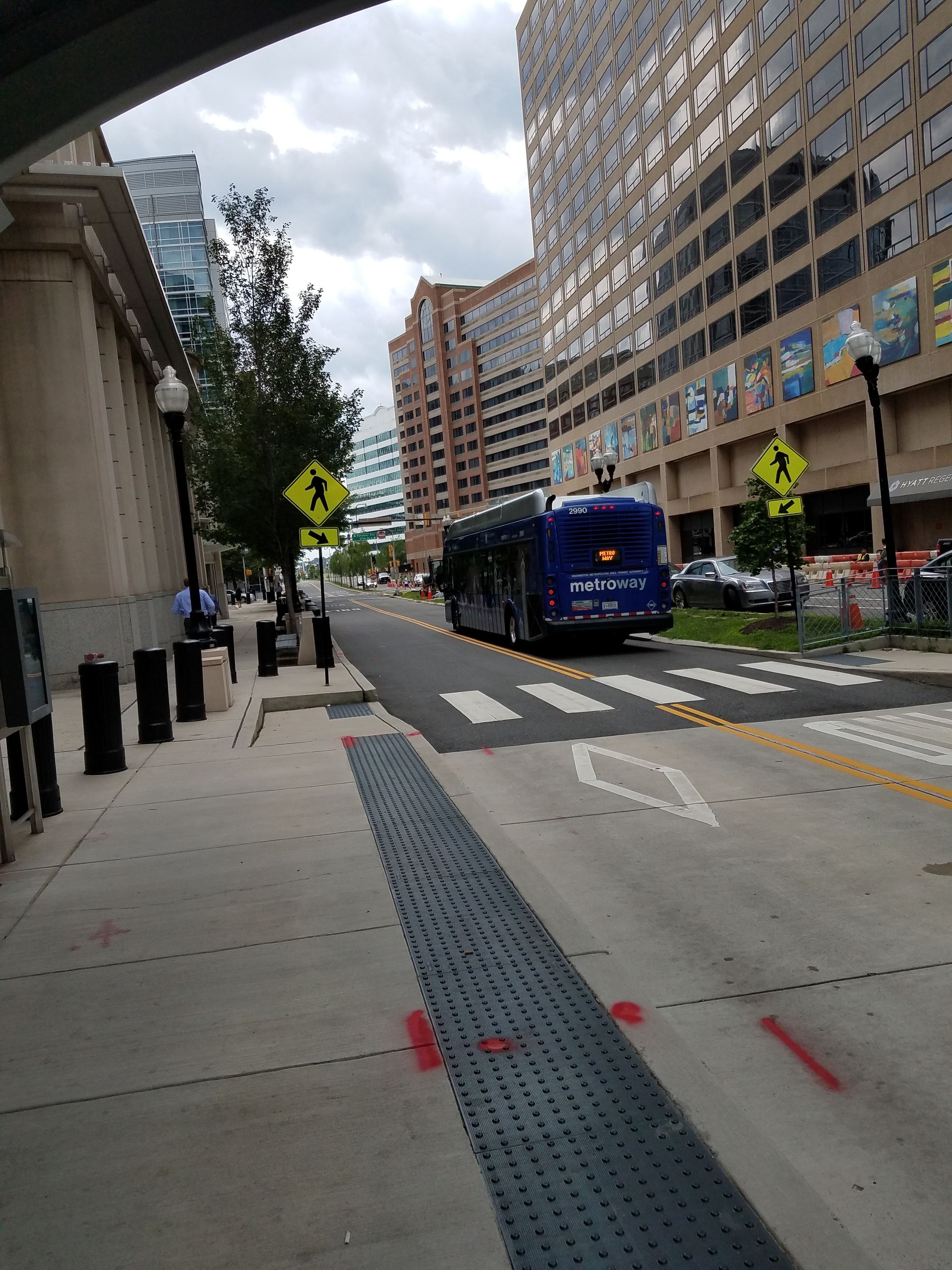
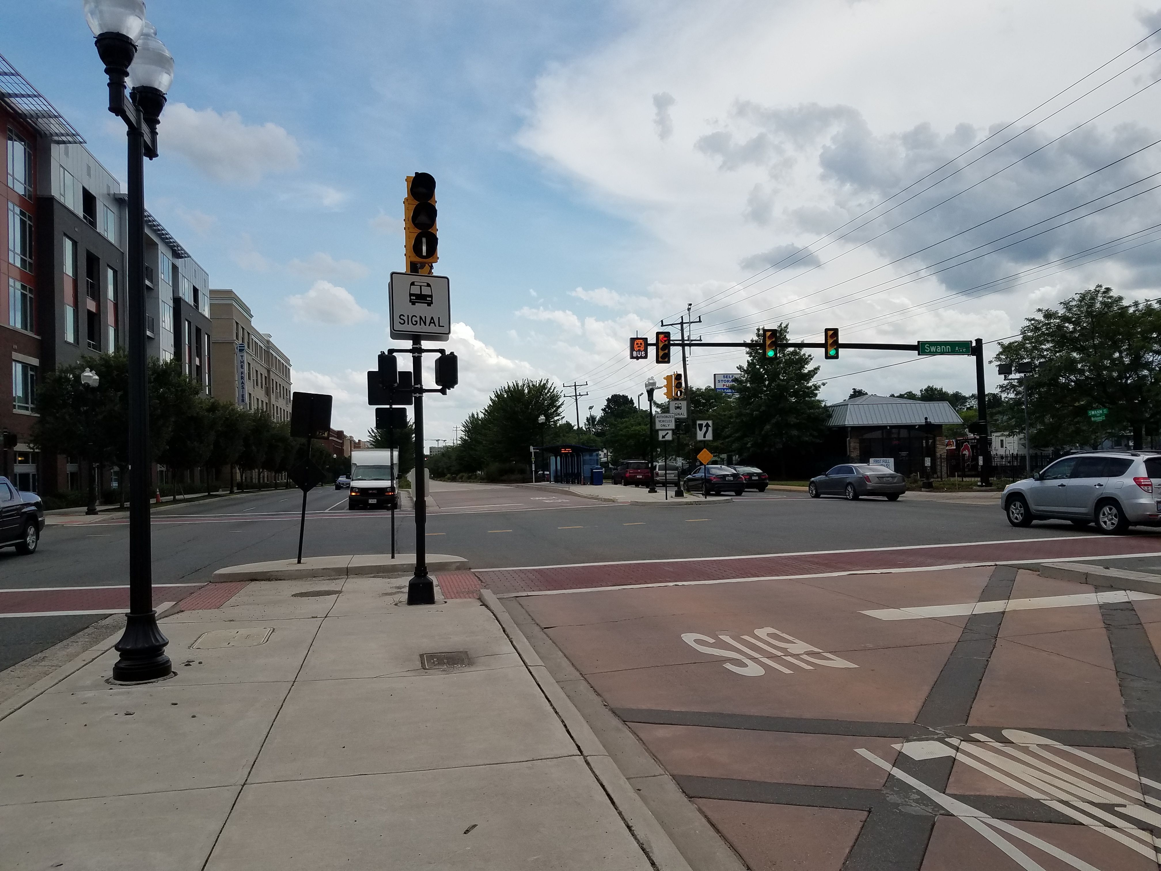
In Alexandria VA checking out the Metroway. This is the perfect model of how BRT should be implemented in our wider corridors like Western, S Saunders, and outer New Bern.
Dedicated median or side running transitway, signal priority, first class platforms and shelters, accurate arrival time screens, dense development along the whole length of the corridor, frequent service, and pretty robust ridership.
BTW I rode a bird scooter to get to the metroway at Braddock Road Metro from where I was at the Alexandria waterfront. Scooters and transit go GREAT together. Sigh, Raleigh.
Like… out of everything in your post, this seems like the lowest-hanging fruit (but probably the most obvious in terms of making transit use “feel” better). Why is our bus tracking system so terrible, anyways?
I disagree with that; it was awful long before that.
I tried using TransLoc as early as 2015, three years before Ford bought it, or back when TransLoc and TransLoc Rider were two separate apps for some inexplicable reason. I remember being pressured by my college orientation event to download it, then hating the interface back then, and how poorly it updated its bus location-tracking.
I was so annoyed, I tried replacing it with the official NextBus app, other third-party apps, and the Triangle Transit tracker website back in the day before settling with the super-pretty, easy-to-use, and globally-useful Transit app.
...but even then, EVERY LAST ONE of 'em had the same issues:
…so I sucked it up, pretended to be an app developer, and looked into the technical side of how our region’s buses are tracked. Lo and behold, every transit operator in this area uses the same dataset (and, evidently, the same hardware) to draw out the route maps/schedules AND build a front end for the bus trackers.
Pretty sure this means this is not a TransLoc problem, but instead, it’s yet another case of “GoTriangle had good ideas but didn’t stick the landing again”. Right? …or am I missing something?
Wolf line used TransLoc hardware and their buses always used to update more frequently and smoothly. I think the other agencies use something else (nextbus?) and TransLoc had to create some kind of translator that could pull the data out of that and into their backend.
Transloc’s main initial focus was getting the buses to move smoothly on the map, and arrival times were kind of a feature bolted on after the fact, perhaps at the behest of Triangle Transit. Their algorithms never seemed to work very well in comparison with comperitors.
Nonetheless I only recall a descent into utter uselessness after the Ford acquisition.
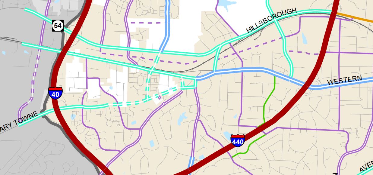
What are everyone’s thoughts about the western corridor?
After looking over the three route options west of Jones Franklin, I think that the only one that makes good sense is the Chatham st. option. This allows for a STRAIGHT route from DTR to DTC that won’t have to make any [crazy] turns. There is good business density along the road from Maynard to downtown. Mark my words–downtown Cary will be the next part of the triangle to urbanize, and people will start wanting to live along this corridor.
The Cary Towne Blvd option is very confusing to me… I’m not even sure what the route they are proposing is? I saw one proposal where it makes a turn from Chatham onto Maynard and then loops around to DTC via Walnut st… What a nightmare. That would add at least 15 minutes to the trip!
The Chapel Hill rd. route is OK… but very few people would use the service from Jones Franklin–>Downtown Cary
The preferred route for the Town of Cary is Hillsborough St to the new Western Blvd extension (From Buck Jones) that will connect to Cary Towne Blvd. From there, it’ll go by CTC/Fenton then To Maynard as you mentioned.
As I live by CTC, I love that route overall. Dedicated BRT lanes have the best shot on Western/Cary Towne and Maynard (not Walnut). Chatham has issues with NCRR corridor. I’d prefer it take Walker or Walnut into DT Cary over Maynard, but then no BRT lanes on Walnut
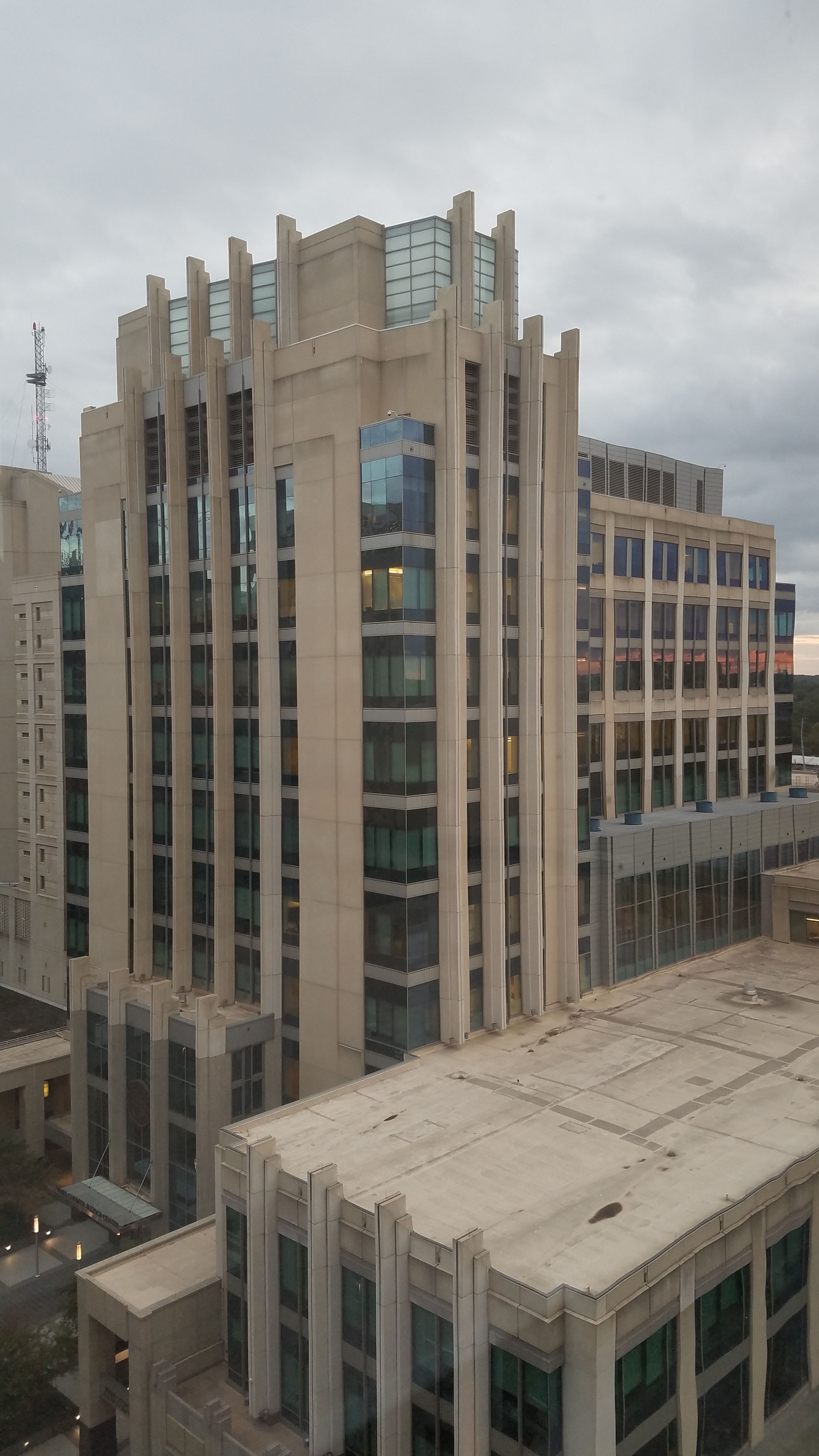
I was up on the top floor of the Capital Club building tonight (HQ Raleigh) and could see the ugliest building in downtown followed by my favorite modern building in downtown.
I think we need to set aside lanes for the buses and make the stops and the buses futuristic and cool looking, and in the bus we could do like in bus WiFi and serve coffee and stuff to really make it a nice atmosphere
I think that’s the best route. It’s not the most direct route between the downtowns but there are so many advantages. They’ll be able to capture the ridership of the new student housing out that way, the apartments along the new Western extension will get a bump in attractiveness and they’ll have better options to get to jobs along the route. The Western Blvd extension should radically open up that section of the City for additional density and improvement. The new CTC/Fenton developments will also be well served and grocery options will be just a few stops from DT Cary.
I don’t think the CTC/Fenton aspect of this route can be emphasized enough. To start with this will probably be the highest retail concentration of the initial BRT routes. There is a fairly new Harris Teeter, and will be a new Wegman’s at virtually the same stop. CTC has an aggressive timeline for redevelopment and will have alot of retail. I think CTC/Fenton is going to be one of the most important stops for generating ridership and making the BRT a success.
I’m split on the Fenton/CTC route vs the Chatham-Hillsborough route. It really is a Trade-off. I am not sure at all which one I would choose.
The Chatham-Hillsborough route can:
Move people as quickly as possible between DTC and DTR. This route is about 1.5 miles shorter and therefore perhaps about 5 minutes faster. Linearity and travel time are important.
Connect with commuter rail at the West Raleigh station in addition to Cary, which might make for a more convenient transfer for some.
The CTC route can:
Connect Fenton and CTC to the BRT. These are supposedly going to be very dense mixed use developments, with thousands of residents and jobs, but talk is cheap and it frankly remains to be seen if developers and the town will follow through on that.
Either way, there’s going to be a lot of heavy construction - either widening Chatham entirely away from the RR, or building the Cary Town Blvd extension. I will be very interested to see estimates; both are likely to be expensive.
My inclination is to say that if there will be a dedicated busway with signal priority for the entire length of Maynard, Cary Town Blvd, and its new extension to Plaza West, so that passengers will never have to deal with congestion in the CTC area, then the CTC route is best. A few extra minutes on a bus that’s almost constantly in motion will not negatively affect the perceptions of passengers that much and serving the destination that CTC and Fenton will become will be worth it.
If we’re talking mixed traffic or poorly enforced, non-separated bus lanes, then forget it and go for Chatham/Hillsborough. Still serve Fenton/CTC with a frequent bus route, but forget the BRT if all it’s going to amount to is fancy shelters. Maybe extend the new Route 9 (Hillsborough Street) there.
Will have to see projected ridership, travel times, and costs to make a final determination.
Note also that Raleigh has plans to make Western Blvd a continuous connection towards I-440 at the Cary Towne Blvd interchange. Raleigh already as obtained about half of the right of ways already.
I should also say that, I hope we build commuter rail with enough frequency and set the fares such that end-to-end trip times during rush hour are not the metric that the BRT lives and dies by. The whole point of the BRT, to me, is to create an urban corridor with many useful destinations and lots of on-off traffic for its entire length. Let the commuter rail, with its two intermediate stops and 80mph speeds, handle the end-to-end trips.
The way the city of Raleigh pitches and promotes the BRT to the general public worries me, though. I don’t know if anyone I’ve talked to about the Raleigh BRT (if they even know it’s happening in the first place) has thought about putting it together with the bigger picture of more walkable developments.
I feel like it needs to take a page out of the DOLRT’s playbook and talk about how it will fit into new opportunities for the city (but obviously do it much better), if a good CTC route is going to stand a fair chance.
The only thing Planning has publicly shown at this point are the route maps -and the surveys about it, so far, just seem like it’s saying “here’s a map!!! Think for yourselves for why these are good or bad”.
Ok, I’m sold on the CTC route. I am very confused by the roads in that area of Raleigh/Cary, and extending Western Blvd to Cary Towne Blvd will make things a lot less confusing.
I guess one benefit of this route is (I think?) a BRT lane would only be required on one side of Maynard. That entire section of Maynard has a middle turn lane, so the rightmost lane could likely relatively easily be turned into a BRT lane (though the turn lane would be eliminated).
I’m all for CTC redevelopment! And one thing I just realized is that the commuter rail will provide that direct DTR-DTC connection.