Based on the presentation, I agree that #5 seems the best. Always glad to see these efforts taking into account not just what is there now but what will be there in a decade (regarding the Wilmington St Southern Gateway corridor).
BRT’s biggest problems in the US are: peoples’ poor image of the bus as a mode of transport in general (which we can’t do much to change immediately) and poor image of BRT systems themselves due to half-assed implementations (in the footsteps of which we have to be careful not to follow). If we’re going to do BRT, let’s do it right, even if it takes a little longer. Otherwise, it’ll be seen as just a more expensive bus line with less frequent stops and forever be a feather in the hat of those seeking to prove that “public transit doesn’t work here”, if not have it’s ROW given back over to cars within a few years due to low ridership.
My questions/concerns (not directed at you): I don’t understand how Alternative 5 scores highest on potential number of riders. Where are these people going to come from? The woods and industrial sites along S. Wilmington? Also not sure how Alt 5 scores highest on bike and ped connectivity. It looks to me like there are far more people living adjacent to S. Saunders than there are to S. Wilmington.
A S. Saunders route would go right through the middle of Downtown South and also be adjacent to Park City South.
Still feels to me like Alt.'s 5 & 6 are being pushed because they’re the easier routes to implement given existing car traffic.
I’m reminded of a couple points from Jeff Speck’s Walkable City. It includes a chapter called something like “Let Transit Work”. From that chapter:
1 - Transit should be located so that riders can fall off their stool at a coffee shop and on to a transit vehicle.
2 - Too many cities make the mistake of routing transit where its easier instead of where it would be most effective.
I loved Walkable Cities! Great book. And, yeah, I think you captured point 1 word-for-word from the book
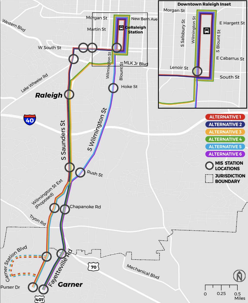
These are all great questions! The only difference between 5 and 6 is whether you build the Wilmington Street extension (pedestrian-friendly) or stay on Fayetteville (pedestrian nightmare). That one factor alone means that 5 scores way higher than 6 on that score. Alternatives 1-4 would all put a stop at Fayetteville and Ileagnes, which would require riders to cross six lanes of traffic to get from one side of the street to the other, which would be awful. But on Wilmington St., you could put the bus station in the median, which would be a huge difference. Wilmington St. also has good bike connectivity. It intersects with the Rocky Branch Trail and the Walnut Creek Trail; the Hoke St. stop would be one block over from the bike lane on Blount St.
So that all makes sense. In retrospect, yeah, I wish I had asked for a little more clarification about how they calculated the potential number of BRT riders, but I suspect it’s a combination of what they learned from community input, the value of the Hoke St. station, and the potential for transit-oriented development. Wilmington St. gets you two focus areas from the Southern Gateway corridor study: the old Cargill plant, and the Wilmington/Rush St. area. Saunders gets you Park City South, yes, but PCS will also be served by the Western BRT Corridor, so the utility of running the Southern Corridor there is a lot lower. The Downtown South group is acquiring land all the way to Wilmington, so both routes would hit DoSo.
IMO, when you’re talking about adding dedicated bus lanes, the ease of doing that has a huge impact on the effectiveness. If the buses have to travel in the same lanes as the cars, the buses will always be slower than the cars. But if buses have their own lanes, and signal priority (which requires dedicated lanes), the buses now become faster than the cars, which completely changes the game.
Agreed Fayetteville St in that area is a pedestrian nightmare. But I wonder which would be more expensive, building the Wilmington St extension, or upfitting Fayetteville St. to be bike/ped friendly? Assuming that’s even possible.
Needing to cross six lanes would suck. Pedestrians have been killed in this area trying to do just that. I like the idea of putting stations in the median, but again, where would the people come from to begin with? What if I live in Carolina Pines, Robinwood, or Renaissance Park? I’d still need to cross six lanes of S. Saunders to get over to the Rush St. station on S. Wilmington.
I’m hoping our system has both of these and I hope our city leadership has the guts to demand it. Overall I want the system to be a success, and maybe there will eventually be enough people living along S. Wilmington to make it work.
BRT needs to eventually be on both Saunders and Wilmington. Might as well start with the easier route, Wilmington, prove it’s a success, then place it on Saunders easier.
Yep. S. Wilmington just doesn’t make sense unless the main criteria is what is the easiest way to route BRT given current conditions?
A S. Saunders route could serve residents of Caraleigh Commons, Caraleigh Mills, the east and west side of Caraleigh proper, Fuller heights (greater density will likely come to that area in a hurry), and let’s not forget the 12-story residential building proposed at the Earp’s seafood site.
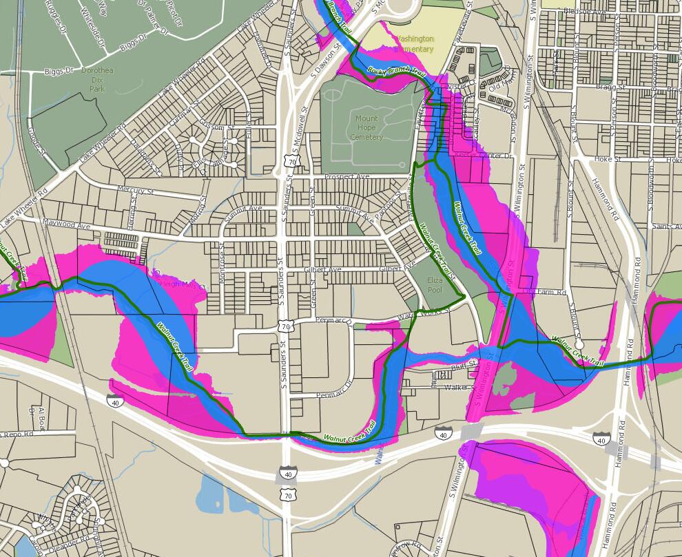
And take a look at the difference in the amount of floodplain adjacent to S. Saunders v. S. Wilmington. I’m not an expert, but it sure seems like infill development would be much more feasible and have less environmental impact with a S. Saunders route :
I was on the ‘prefer Wilmington St’ side, but this convinced me S Saunders might be better. Biggest hangup for me is how do they make S Saunders pedestrian and bike friendly (absolutely necessary to feel safe to get to the bus stops). Right now feels like a highway inches away from you on the sidewalk.
Yes, S. Saunders would have to be transformed into a walkable/bikeable corridor - at least between I-40 and Western/MLK. Wouldn’t be easy, but neither would building out around S. Wilmington.
Southern Gateway Corridor Study might be a place to start figuring out bike/ped connections along S. Saunders. Although that study also recommends converting S. Wilmington to a transit corridor.
I had written about this before, but I’m just now realizing that was on a Twitter thread and not here, so here goes.
There are three ways to go about putting BRT on South Saunders while making it a better place for people.
Reduce car capacity on South Saunders. Narrow it to two car lanes in each direction from the Wilmington split south of I-40 to downtown. Maybe even only one through lane in each direction for people traveling north/south across I-40. The goals are to
Get as many people as possible driving from Garner to Downtown to use Wilmington Street instead.
Discourage use of this corridor for through traffic between Garner and Capital Boulevard (Use the beltline instead!) This cuts down on Dawson/McDowell traffic, too
Doing this in the existing 120’ right-of-way yields a configuration like US 1 through Alexandria, VA which is IMO an acceptable outcome: 2 general traffic lanes in either direction, and a median busway.
Reduce car capacity on South Saunders as 1 above, but also add an interchange with I-40 at South Wilmington Street. This would be challenging and would require braided ramps and some property acquisition, but not impossible.
The goal is again to get still more people to drive on Wilmington instead of Saunders. Since the I-40 interchange is perhaps the main source of traffic on Saunders, splitting that traffic with Wilmington will almost certainly be effective.
It also makes the Bluff Street portion of Downtown South, as well as the Cargill site, more valuable and more attractive for redevelopment. (Interchange could be partly funded by TIF?)
Do a one way pair with South Saunders and Green Street through Caraleigh and Downtown South. Leave southbound cars where they are, move northbound cars onto Green Street, and put
the BRT where the current northbound lanes are on South Saunders.
One way pairs can handle much more closely spaced stoplights while still accommodating a lot of traffic flow, meaning you can create a grid that really connects across South Saunders.
The streets will be less intimidating to cross. Rather than having to cross six lanes of traffic all at once, you’ll cross it three at a time. Dawson and McDowell are nobody’s favorite streets downtown, but crossing even both of them is still much more pleasant than walking across South Saunders.
Current residents of Caraleigh and Green Street would understandably not be too enthused about this, but the way I see it, the blocks between Green and Saunders probably should and will redevelop over time.
This would put 9 pairs of traffic signals up and down the Saunders/Green one way pair, meaning 9 safe places to cross the street, instead of just one today, at Maywood. For comparison: Dawson/McDowell each have 11 signalized intersections downtown. This may sound crazy, but regardless, it would look something like:
I’d be totally on board with option 1 (and, long term, I think you definitely could and should have calmer streets and excellent bus service on both streets), but think option 2 (adding another I-40 interchange) would be actively bad. One of the appeals of Wilmington St. as a route is that you don’t have I-40 traffic to accommodate; instead it’d be a route for people traveling north/south to and from downtown.
S. Saunders-to-McDowell was obviously designed to funnel people from I-40 to downtown, which was a terrible idea, but now it becomes really tough to put that genie back into that bottle. If you could go back in time and start from scratch, sure, Grid Plan Alpha would be way better than what we have now, but I don’t think there’s any way you could actually push this though, except maybe as a piecemeal effort spanning decades.
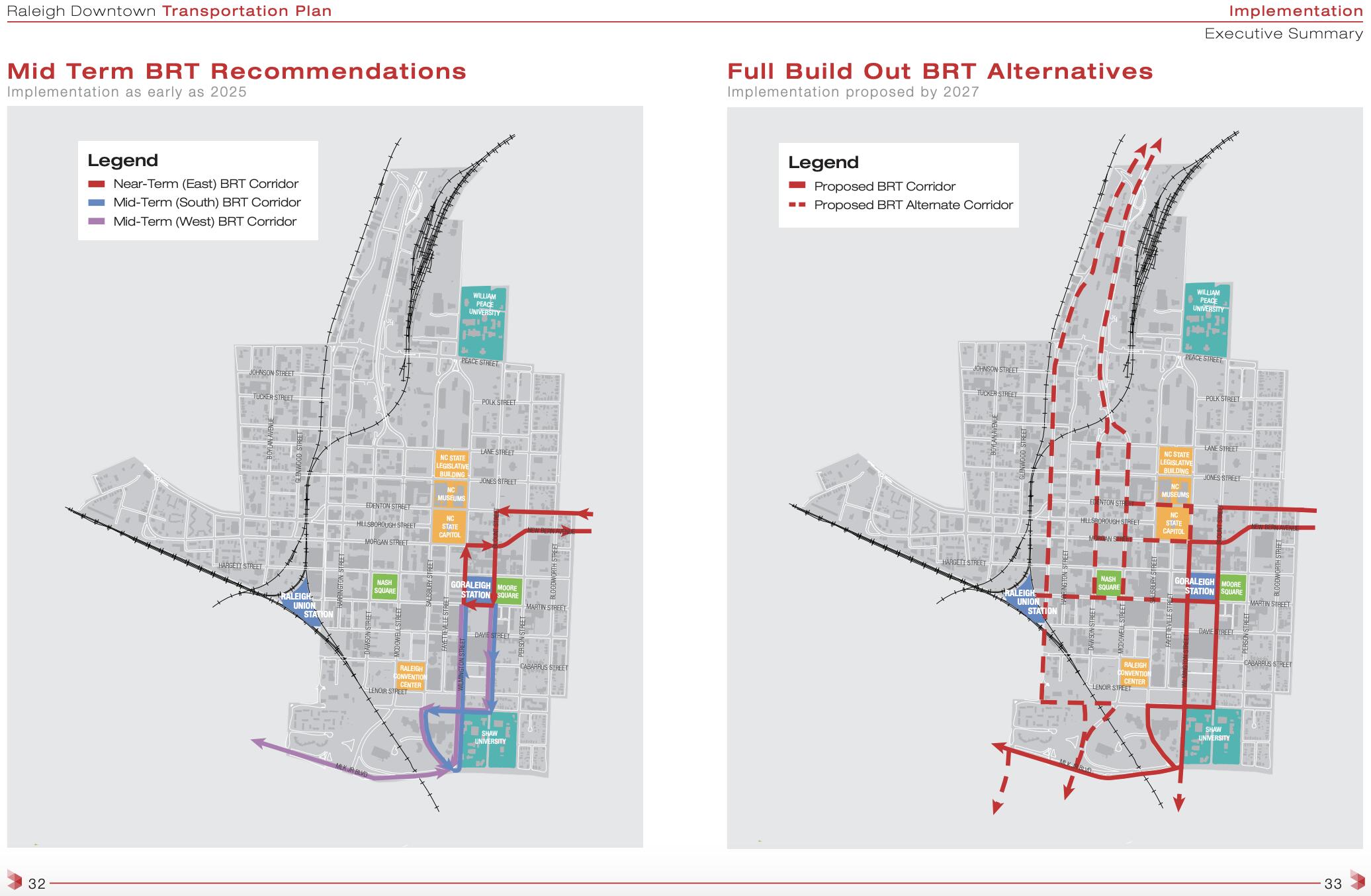
The other advantage of the Wilmington St. route, of course, is that whichever alternative you choose, you ultimately need to end up at GoRaleigh Moore Square Station, which is on Wilmington St. So if you pick that route, it’s a straight shot, and you’d have a dedicated lane almost the whole way and signal priority probably the whole way, which is huge.
If you pick any of the other routes, first you have to extend the length of the route by detouring away from Wilmington. That added length would all be in places where you would lose the dedicate lane. If you pick Saunders to McDowell, you’re steering the buses right into a very congested bottleneck. If you go Saunders to South, the detour is a lot longer, and you lose signal priority as you move a long way west to east. The other routes would end up adding a lot of time to the journey, which could have the effect of significantly depressing ridership.
Honestly, it sounds like the pros and cons of a Wilmington approach (versus a Saunders/McDowell approach) with respect to Raleigh kinda even out. They both have their own benefits, risks, cost sinks, and possible accessibility issues, so I feel like it’s hard to make a decision call without agreeing on what exactly we want out of a southern BRT alignment.
Are we looking for an easier way to get between northwest Garner and DTR? Or better access for existing neighborhoods? Or just better development opportunities? …it sounds to me like previous studies didn’t go any further than starting this conversation -but we’re just left asking more questions like this. We need to have our values and priorities straight, if we’re going to do something that actually won’t be a pain in the ass for the whole region.
Also, we seem to be caught up on the Rush St.-Western Blvd. segment but that’s only like half of the corridor. What about the other features? Specifically (see @daviddonovan’s post):
Does the Garner Station Blvd. detour (alternatives 1, 3, and 5) make sense?
The Wilmington St. extension may already be planned -but is that something to rush and force into a priority?
Assuming we cannot do a Wilmington path for some reason, should Saunders/Lenoir or McDowell be your RED carpet into DTR?
Does anyone have a better grip on what the residents around here really want in their improved access to Raleigh and beyond? An awful lot of this topic (both from the city and on this thread) seem to be about traffic and development -but my gut says there’s something more hidden that should be addressed.
As a reminder, here’s the map of the proposed basic alignments:
You would think so, but they’re planning on ending BRT lines at GoRaleigh Station (the bus terminal near Moore Square). It turned out that it’s a major pain to put bus lanes that connect both bus stations and still work with all the one-way streets in DTR. Since public comments from last year’s Downtown Transportation Study were more positive about the recommendation options that go through GoRaleigh Station, we’re stuck in this catch-22 situation with a funky-lookin’ route.