I don’t know that that connection is planned at this point. The Lake Wheeler/Saunders intersection will be modified in the near future though, to reduce the angle.
1 Like
I am actually not such a fan of the “square loop” thing here. It puts highway-volume traffic, onto a road that’s more of a regular downtown street. My understanding is that it feels pretty hostile as a pedestrian where they did this with Capital Blvd at Harrington. I would maybe prefer a diamond interchange built as tightly as possible while keeping the existing bridge.
Like @atl_transplant suggested, I’d also like to see a West Street ↔ Lake Wheeler connection via an intersection with Western Boulevard. Let the South Saunders Street underpass be a pedestrian only thing: the main entrance from Downtown to Dix.
Basically, this:

The concept for that Pullen/Western interchange is lit ![]() allowing a direct connection between Wolfline and BRT at this spot is a great idea, and putting it in the middle of a traffic circle-style interchange is … really cool.
allowing a direct connection between Wolfline and BRT at this spot is a great idea, and putting it in the middle of a traffic circle-style interchange is … really cool.
Also, I dig the creek daylighting project and tunnel under Western Boulevard, which connects Pullen Park (and NCSU) to Dix Park, giving the Rocky Branch greenway a grade-separated connection of Western Boulevard. While it sort of duplicates the functionality of the land bridge, that’s really not a bad thing: the land bridge has always struck me as a great idea, but bound to be expensive and sort of likely to be a “finishing touch” on the whole Dix master plan. On the other hand, this Rocky Branch underpass seems like something that could move forward pretty quickly. I would imagine it would look pretty similar to the Rocky Branch underpass on Pullen.
11 Likes
Wouldn’t this depend on the traffic pattern? I think a diamond interchange be worse for pedestrians (a square loop would at least look like a regular road, crosswalk-wise). Besides, I’d need to see the traffic study for that intersection but whenever I’ve driven on Western/McDowell, I’ve felt like there’s far more traffic going through the interchange than turning on it in any direction.
I think a West-L.Wheeler connection would be neat, too! But isn’t Boylan Heights a historic district where road expansions aren’t kosher?
2 Likes
Looking at the volumes, the movement from Dawson SB to MLK currently carries around 4,700 while the MLK WB to Dawson SB carries 1,800 and MLK EB to Dawson SB carries 3,700. So putting that altogether on a Two-Way street we’re looking at around 10,000 VPD. Which in a vacuum isn’t that many. For comparison Dawson / McDowell through the interchange carries around 42,000 currently. It’s certainly doable on the square loop but it may get sticky in the afternoon. But it helps that the heaviest featured movement would be Right onto MLK. Same goes if we do a similar quadrant roadway on the SE Quadrant. Unfortunately I don’t have access actual TMC and Peak Hour counts to do some actual predicting. But your point of most traffic going through rather than turning is 100% spot on. My one worry though is that once the Western Blvd extension / connector to Cary Towne Blvd is erected that this may become the route of choice for vehicles between Cary and Downtown and we could be looking at some much higher volumes through here.
Big wildcard in this could be to tie Wilmington St into I-40 as the official Downtown Gateway
How @orulz had mocked it up and how I’m drawing it in Microstation (one day I’ll have enough time to finish and post it haha) keeps it out the historic district and just snakes through the Apartment complex and connects directly to West St.

7 Likes
I can see it being hostile as a pedestrian on Capital at Harrington. I wonder if there’s going to ever be a traffic light put in. The flow through from Capital is what is more than likely making it hostile. It would also cause phase 3 to be disconnected from the other part of the Hollow.
3 Likes
I think even if they just made the traffic coming off of Capital have a stop sign things would be better. I know there’s rules about a minimum distance off an interstate that would be needed before a stop sign is disallowed but Capital is only a 40 MPH expressway at that point and the ramp is pretty low volume and would not queue onto the mainline. There needs to be a stop sign there ASAP imo if signal warrants aren’t met.
2 Likes
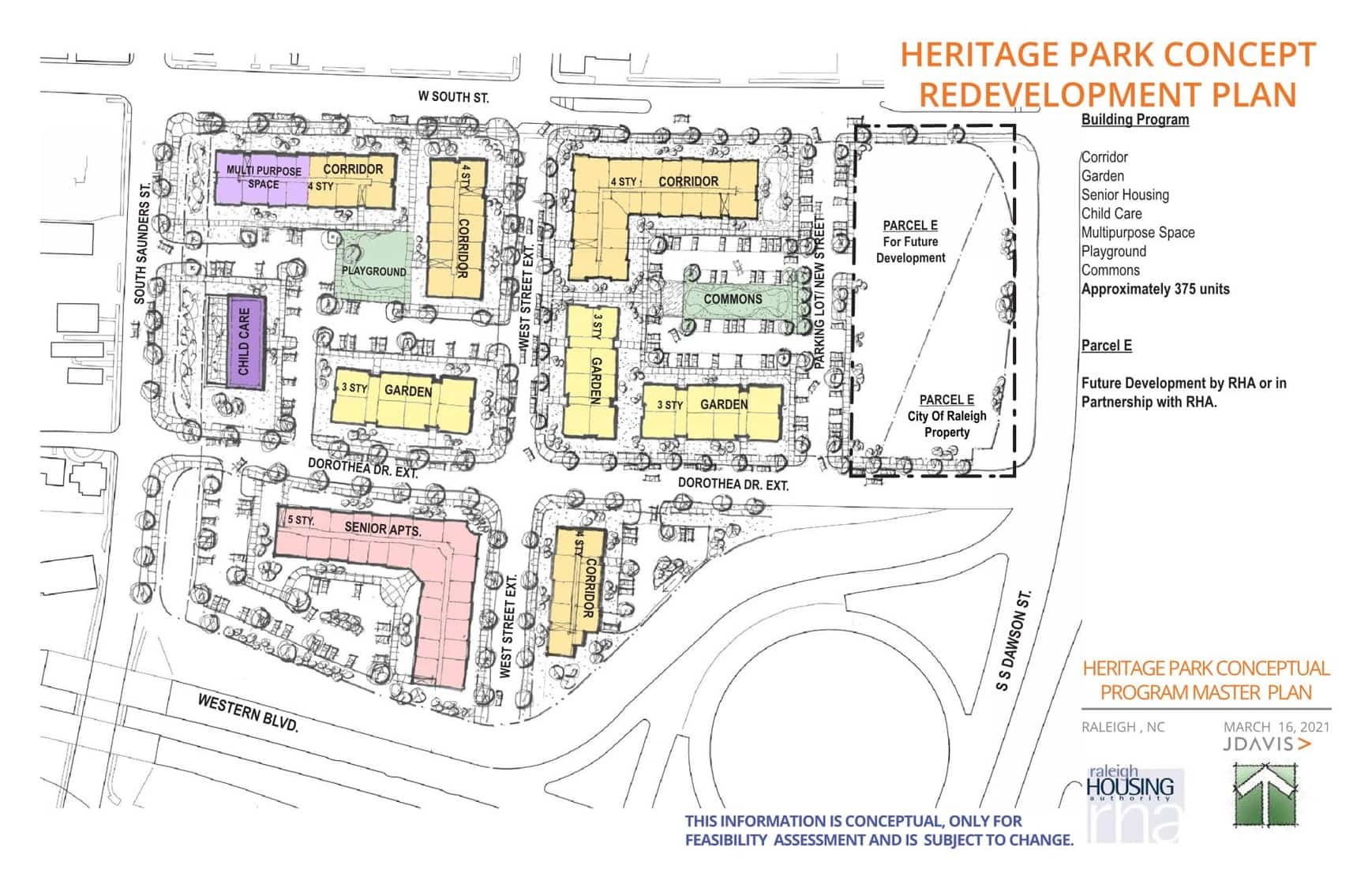
I do like this layout, but the lost units of the public housing would need to be accounted for. They could build a newer high dense public housing building on the corner of W. South and South Dawson for public housing. At completion, the older units could be town down for more public housing units.
1 Like
I think (Really really hope) that is the cities plan to not just sell the complex off and redevelop it as a denser affordable complex
They are definitely planning to redevelop Heritage Park for affordable housing. I have no idea what that will look like.
There are about 120 units today, if I recall. It’s a lot of land: about 12 acres. That much contiguous acreage downtown would be worth A LOT to a developer, so I can see RHA partnering with a developer with the land being their contribution, as well as maybe some AH bond money, and receiving a large number of affordable units in return.
Anything less than a total of 1000 units would be a travesty; 2000 is a better target in my mind. 2000 units at 25% affordable would increase the number of affordable units to 4x what’s there now.
9 Likes
Not to derail the topic, but do you know where “they” are in the process of this effort? I was under the impression from the recent rezoning approval of 328 W South St that there was some component of Heritage Park being redeveloped (for AH).
1 Like
Yes, venturing further off topic, but… The current preliminary concept is very disappointing. Surface parking?? Give me a break!
They are setting aside a parcel along Dawson for future development, but that certainly won’t make up for the unambitious size of the rest of it.
2 Likes
I don’t hate the layout and mix, but at least make the three 4-story apartment buildings something like 8-12 floors.
1 Like
Well that’s a letdown! Why even bother razing them to basically put them back in place. Who’s over this kind of stuff?
5 Likes
Gotta imagine they are trying to avoid poking the Boylan Heights hornets nest.
I actually don’t mind the square loop as it helps create a contiguous street grid. Western/MLK needs to be slowed down a bit in the immediate vicinity of downtown anyway.
3 Likes
Some 65% design sketches of the New Bern BRT are available for review on the BPAC agenda for May 17:
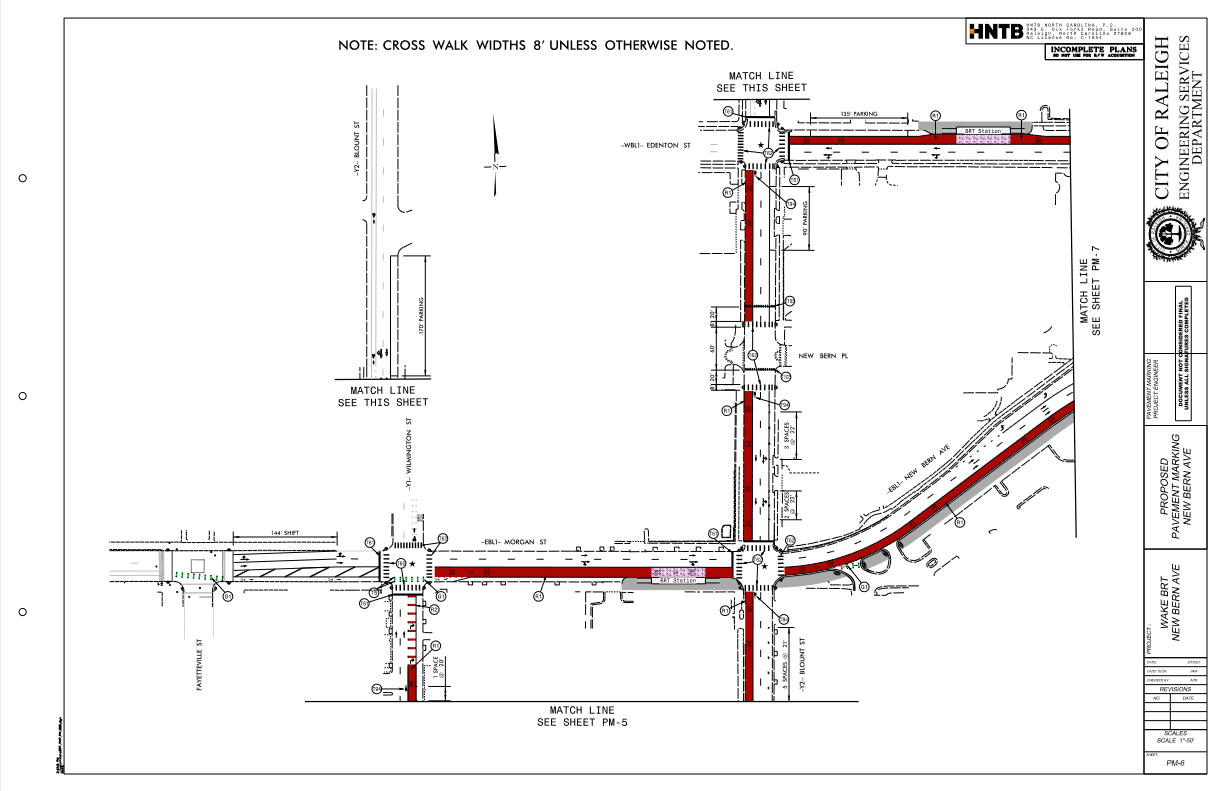
The whole route isn’t shown, but this gives an idea of what might be expected in terms of station placement and lane markings.
4 Likes
Is the bus lane shared with the bike lane??
I believe they are only shared along Morgan from where the bike lane merges into the bus lane just past Wilmington to just past Blount, where it transitions to the off-street mulituse path that will be constructed along with the BRT line. I don’t see any other shared markings.
2 Likes
Last week’s GoRaleigh board meeting included some updates! For example, the names of New Bern line station names are finalized:

(Though it’s still not clear whether we’re going to call it the “New Bern Line” or something else… but we’ll see I guess)
There’s also a look at the Wilmington St. stop on the New Bern line. It’s basically in front of Tonbo Ramen and Blalock’s Barber and Salon so that the wheelchair ramp leads straight to GoRaleigh Station:

If you (don’t) like the station design, proposed Go+ branding, station LPAs etc., remember that the city wants you to tell that to their face by the end of this week.
The slides also include updates on bringing more seats to more bus stops (remember that article from last month?) and post-pandemic ads. Y’all can look at that yourselves if you care, though, since it’s off-topic from this thread.
12 Likes
That sounds like a very viable plan for the city to get affordable units by leveraging what it basically has to offer (the land) without contributing the upfront money that’s difficult to find these days.
Connectivity in this area becomes an issue with the sort of density that could come with maximizing the property (2000 as you suggest). For context, Smoky Hollow doesn’t even have half as many units at this point. The West St. connector @ Union Station certainly helps, and having RUSbus transit hub nearby does a well, but I wonder if something needs to happen with S. Saunders St. as well? Is the stretch of that road from Lenoir St. to the Dawson/McDowell merge the right section for future success, or does it need to start looking more like Hillsborough St. with a balance of transit/pedestrian/auto infrastructure?
1 Like
Someone on twitter mentioned that some BRT stations will have secure bike storage as they expect people will need to ride to the bus station but not need to continue their commute lugging their bikes. That seems like a smart idea. I hope it happens.
10 Likes