Shoot, I wish I’d know about that. Is there a recording floating around?
1 Like
I don’t think so, it was a webinar with the NC Institute of Transportation Engineers
Ah, that makes sense. Sounds promising though.
I’m really hoping that USDOT gets bullish with freight railroads during this administration. I don’t think Norfolk Southern is going to cooperate until their hand is forced by the feds. They seem to be the worst of the bunch when it comes to passenger rail negotiations.
3 Likes
Can you talk about a bit more about this? I know NCDOT is involved with GTCR, but aren’t they just acting like advisors since they’re the sole shareholder of NCRR and this project will fall under their jurisdiction?
To put it another way, I thought we’re only playing around with the idea of NCRR operating the Durham-Garner commuter rail line, here on this site, because @orulz suggested it last month and we really liked it  What did NCDOT say that made you think they were thinking about that approach, too?
1 Like
I don’t think there’s anything new that she shared that we didn’t already know (NCDOT is at the table with the planning process with the GTCR).
2 Likes
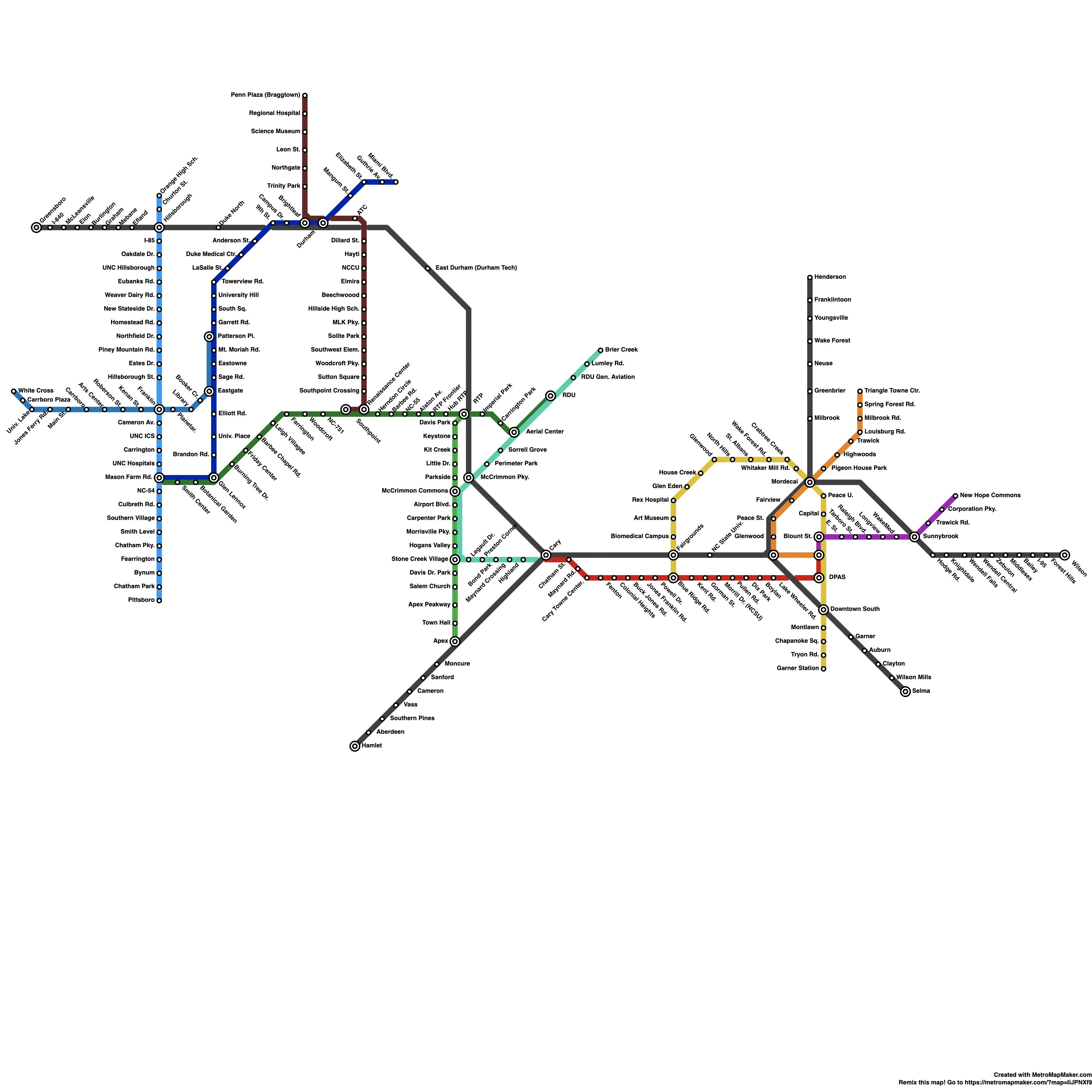
Someone on Reddit mocked up a light rail map for the Triangle. If only…
14 Likes
The Apex-Pittsboro segment kinda cracks me up. I can see that for intercity passenger rail, but can you imagine how long it would take to do that route via light rail, running down the US-64 median and getting off at a random intersection with a gas station and two houses while cars haul past you at 65mph? The rest of it seems somewhat reasonable, but that segment is just bonkers lol.
Would probably still ride it though ¯_(ツ)_/¯
4 Likes
Yeah - seems silly to have a line connecting Pittsboro, but not WF. But I guess it’s all just dreaming for shit’s and giggle’s.
2 Likes
I commented on this but I love how someone draws up a new transit map each month on the Raleigh reddit but somehow is completely uninformed about the actual transit projects that are happening in the area (like none of that is incorporated into his map)
6 Likes
light rail across Jordan Lake? ROFL
it’s a colorful, pretty map, but that’s about it
3 Likes
What I’m looking forward to:
- 15 minute frequency from Crabtree to downtown.
- 15 minute frequency from North Hills/Downtown.
What I’m hoping for:
- Bus route from Crabtree to North Hills.
I’ve found that if you want transit, you need to move where it’s at. You can’t completely expect transit to come out of nowhere. I normally move to areas based off a transit line that I’m planning on using.
Technically I don’t need a car living near Crabtree. Taking the bus gets me downtown now (higher frequency this year will make it better), to the grocery store, and I can walk over towards North Hills although it is a bit of a walk.
I walked over to DSW from Crabtree on my day off for an urban hike. Once I got new walking shoes, I took the 24L back to North Hills and walked back home. I’ve also used the 23L to 2 to meet up with some friends for a drink over near that area as well. If people want transit, they need to support their current transit options.
9 Likes
Interesting question - assuming full implementation of the Wake County Transit Plan, what area outside of downtown Raleigh will be the best place to live from a transit connectivity perspective? (that may not be currently)
5 Likes
You mean you walked from Crabtree to Holly Park? 
I’ve got to say, you’re the spirit animal we need in this endeavor…Love it.
Most folx out there have probably NEVER digested how easy what you say is currently and how important it is that we make these ‘internal’ connections more frequent to change more minds / patterns.
1 Like
Downtown Cary, no question.
3 Likes
I think there are already numerous areas that are great places to live from a transit connectivity perspective. With the full implementation, it would just increase.
In general I consider places with good access to grocery stores or jobs to be the important thing. Ok access to shopping such as the malls (DTR is still lacking in low-cost retail) would be acceptable since shopping is not an every day or every few days thing. Grocery shopping and commuting to work is more important as those places are frequented most.
Based off the above reasoning, there are plenty of areas that have this. It just depends on where people work. I like to live decently close to work with easy access via a transit route. When I lived in RTP, I used the 100 bus. The 100 bus/RTP area could be good if they pushed 30 minute frequency until 8:30PM. I commuted to downtown. The problem is I started at 9 and would get off at 6pm. When I would get to the GoRaleigh station, I would make the 6:40pm bus departure. I would love to have stopped along Hillsborough to get food or stop by Target; The problem is that I would have to wait until the next bus that came the next hour. It did not make for a good quick 15 minute stop by Target or some other store on my way home.
4 Likes
I will do it on my day off because then I have the time lol. I have this mindset that if I travel someplace for vacation, there’s typically a lot of walking happening. For example when I went to NYC, we walked 6 miles for the day. Same goes when I go to DC. When I go to the zoo in Asheboro, it’s about 4-5 miles around the entire thing. So I consider the walk to be my vacation time/day just enjoying nature while doing something else like shopping or going to a museum. According to Google, the bus would take about 35 minutes for the same thing which isn’t bad at all.
I think part of the idea of using public transit needs to be that you stay the majority of the time in your community (anywhere else is a day trip). I believe this to be true in larger cities as connections can make travel times longer regardless of how good the transit is.
On a separate note, it was reported that people in NYC walked around 7,500 miles per day (pre-COVID). That equates to about 3 miles in a day I believe. I think people will talk about how nice it must be to live in a big city with good transit but don’t realize how much walking still happens.
5 Likes
A more realistic version of that? Challenge accepted 
To @wanderer’s point though: I feel like it also depends on the environmental design, or how walkable some communities and some blocks are? Walking 1000ft on Fayetteville or Glenwood feels like nothing because there’s so many people and interesting storefronts. But the same 1000ft stroll would feel like an eternity on Wade Av., where cars would be zooming by you without a care for the world by drivers.
That’s probably the single thing that makes my map unrealistic: I’m asking Cary residents to leave their cars at their favorite strip malls and hop on BRTs, which has got to be an unappealing chore, at best.
8 Likes
Can we make this a subway inside the DTR core (use The Boring Co.) then daylight to monorail where it makes sense. Plus we need room for the Gondola overhead.
5 Likes
In addition to the gondola, with the carriages shaped like acorns, I believe we also need high speed glass tubs that shoot different acorn cars at high speed through compressed air or mag-lev technology.
3 Likes
Did a map myself, I tried to stick to real tracks/streets for this. Note: regularly named lines are LRT, “Regionals” are commuter rail. This does not include real plans (for example, New Bern BRT), but rather my own take on a realistic transit system for Raleigh.
Raleigh-Durham, NC (real) (2rOuRE7J) - Metro Map Maker
2 Likes