@Mark The banjo is indeed W. African in origin. The way it transitioned into one of the most important instruments of Bluegrass is one of those cool cultural blendings that help define the South.
1 Like
I think Capital to Wade/40 was the original leg…?
1 Like
Not sure the sequence. I just know that when I was in high school it stopped at Poole Road.
1 Like
When Sir Walter Raleigh was granted a charter to set up a new colony by the Queen in the 1580s, part of the agreement was that he would establish a new city and name it Raleigh but he never got the chance. So the idea of the city of Raleigh has existed since the 1580s, way before it was officially established in 1792. Kinda cool knowing that the concept and plan for the city of Raleigh has existed for over 400 years…
8 Likes
the section from New Bern to Poole road was built around early 70’s like 70 to 74 or so time frame. We lived not far from the construction and remember getting up early on Sunday mornings and walking a loop along construction area, walking from 64 (New Bern) to Poole road then through neighborhoods by Wake Med back home. Lived in area from 9/69 to summer of 72 when I moved out on my own to north Raleigh.
2 Likes
When my family moved to Raleigh in 74, the Beltline still ended at New Bern. From what I seem to remember, I was like that for some time after that.
Maybe the finish date was later than I thought, after I moved did not spend much time around that area.
this is from 1974 NC Map
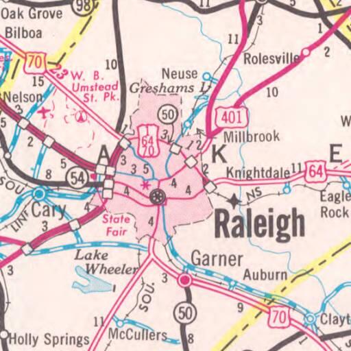
8 Likes
This map is weird. It doesn’t zoom in to show more streets when I double click, and it doesn’t know my current location or read directions to me. 
3 Likes
It’s like those videos on youtube where they give a gameboy to kids and they try to use it as a touch screen!
2 Likes
I got two old rotary phones from my grandmother’s house. My kids are fascinated by them, but have no idea how they work. haha
3 Likes

3 Likes

3 in 1 fail
1 Like
and more fun!

3 Likes
I’m pretty sure I could watch those all day long. I feel smart now. Thanks, @John.

2 Likes
You and me both. I can totally fold a map!
Every year I used to make a point of stopping at the NC welcome center on the Interstate and pick up maps for my parents and brothers to put in their Christmas stockings. Good times.
1 Like
My grandparents were AAA members and they’d order “Trip Tiks” I believe they were called. Essentially a page by page map with the route highlighted (by hand, poor people) and I’d help them navigate from Central Florida up to the Ashville area where their cabin was. They’d occasionally order one with a more scenic route up through GA (avoid 95/26). Diesel was also like $0.88/gal at the time.
3 Likes
I remember those, but can’t offer confirmation that that was what they were called; I simply don’t remember.
It’s funny to think that such things were necessary for long haul trips since they happen mostly on just a few well marked Interstates. I can totally see how they’d be helpful if you wanted to take a scenic route instead!
Yep, they were called Trip Tiks. I used them a few times way back when. If you were driving to an unfamiliar destination by yourself, they were easier (and safer) to use than a traditional road map.
2 Likes
What was that area around New Bern Ave like in 72? I live near Enloe highschool and always wonder what it was like when the older homes were not 60-70 years old. Lots of them would have been ~15 years old back then.
2 Likes
As for what things were like. This past Christmas I drove by the two houses parents owned during late 60’s into mid 70’s and they both look just the same. As well as neighborhoods general appearance about the same. Maybe a few more cars parked on streets and thing I noticed the streets in some places are creaked and could use repaving. LOL do not think I would be riding bike full speed on some today. (btw I’m a Enlow 1970) grad)
2 Likes