IMO, the biggest flaw with the candy cane route is that it isolates the Warehouse District and ignores Union Station.
1 Like
Isn’t that sort of how it is right now, anyways?
GoRaleigh and GoTriangle buses already pass by the area, a few blocks away (though, obviously, it doesn’t feel like it’s closeby… but that’s more of a streetscaping problem). But beyond that, I don’t think there’s a lot of incentive to specifically connect it to Fayetteville St. and eastward by circulator until RUS Bus becomes a thing.
The current route has (I think) 2 stops on Morgan near Citrix and Dawson, and then goes into the Warehouse District after 6pm with stops at Hargett/Harrington and in front of the Depot. So the Warehouse District isn’t left out as much currently.
2 Likes
I think that the current route has an evening appendage that makes a detour through the Warehouse District, right? The regular route at least runs on two side of its perimeter.
Let’s keep in mind that when the route for the RLine was established, the bulk of the stuff there now wasn’t there. Now that we have Union Station an other attractions & businesses, it feels like the wrong decision to not include it.
One way to possible rectify this is to extend the candy cane end further south to at least Hargett Street.
I think two major criticisms of the proposal will be:
- Does not serve the warehouse district, like you say @John
- Does not connect GoRaleigh and RUS at all
Can’t stress enough that this process isn’t final so let’s keep the discussion going but to respond to these points, #1 came out of a data-driven exercise. When we look at the current route:
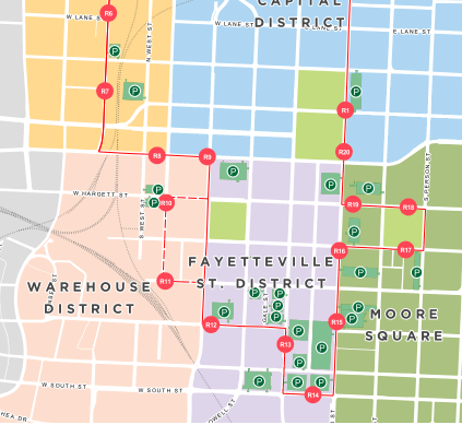
the data shows that the warehouse district had the lowest in terms of where people are going and boarding the R-Line. The R8 stop, the Morgan Street Food Hall stop, had the lowest in the system.
Serving this area of low ridership hurt the overall system’s performance. If cut, and considering that Fayetteville Street (Convention Center and the stops around Moore Square) and Glenwood South (Tucker Street) having the highest boardings with the Seaboard stop getting a decent amount of activity also, you can’t help but consider cutting it out.
It also responds to a big criticism that the R-Line is slow which should not happen with the candy cane.
Now, I know, as well as everyone on here, that the warehouse district is growing so why not serve it? Well, this goes back to a question of priorities. We have a fixed budget line item to work with. There’s no new money here so this seems to be what we get.
On #2, a GoRaleigh <-> RUS connector will be a separate effort. Today, it is served by the 30-min frequency route 13.
Certainly not great but seems appropriate right now before RUSbus is open and commuter rail starts showing up at RUS. This can be improved in the future.
That’s my politicians speak anyway. I’m hoping it evolves over time.
6 Likes
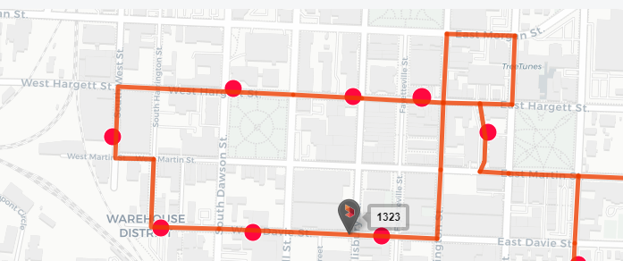
So to be clear, the Candy Cane route would go up (South) on Glenwood South to Hillsborough and loop around Edenton and back down (North) on Glenwood and then over to Salisbury to go South again?
No. The route would use West instead of Glenwood. Here’s a map from an earlier post.
With all busses still going counter clockwise?
Yes but only because of the street directions on Salisbury and Wilmington. This is a more linear route because you can just walk the one “block” over to the other side to catch it going in the direction you want.
2 Likes
Great. West is better. What was the advantage of going back down West and up Salisbury instead of continuing South on West to Martin and across Nash Square. There is a lot within a block of West and Martin and there is very little on Salisbury. Was this considered?
I’m guessing most of the data are from the time before activation of the Warehouse District. And in the time since MSFH, Union Station, and the Dillon have opened, scooters were a big fad, which surely impacted R Line ridership.
I just wonder how representative the data are of ridership going forward regarding this area.
1 Like
I’m curious about the time window within which this data was collected. If it goes back years, then “duh” about the R8 stop since MSFH wasn’t there. I mean, it’s only got 9 months under its belt.
Believe me, I am all for data, but data also needs some context and what’s happened in the last year in the Warehouse District is a huge disrupter and game changer.
I get why the candy cane idea is a good one. I especially like the fact that, if I barely miss it going in one direction, I’ll be able to wait until it soon comes in the opposite direction by either crossing West St. or walking one city block. I’d just like to see its western “loop around a block” moved a couple of blocks south.
Also, is the city considering moving away from full size buses to smaller trolley type vehicles? They did this in Miami Beach with their former South Beach local bus and it’s allowed them to expand coverage due to trolley’s being a lower cost option to operating large buses.
1 Like
Seems like they would just finish the loop down west to Uninio Station, and then head east.
@djberryann and @Kanatenah The candy cane is considered a linear route rather than a loop. If you connected if around then the route would resemble the current loop and we’d have the “it’s slow” and “it only goes in one direction” problem all over again.
While physically not in a straight line, it operates in a straight-line. (if that makes sense at all)
@deb and @John Data was as recent as Summer 2018 IIRC from the meetings so who knows. They had real good data from July 2018 as that’s when they did a rider survey with hundreds (like almost a thousand) of rider data points. I agree, a lot has changed quickly there also.
It’s our understanding that there will be a complete retro on the whole branding and vehicle type of the R-Line. They are figuring out whether to change the whole blue/green bus scheme to something else or not, should it be a trolley or traditional bus. Something else? It’s all on the table as they’ve said. Please weigh in with your thoughts on that when the public feedback period hits.
I personally think a trolley, still big enough for large groups, but smaller with more character, would work well versus a hybrid bus or even the new CNG buses.
It’s still operating on the assumption that it will be a fare free service by the way.
5 Likes
Admittedly I have not studies all the options and reason. It was just the first thought I had when I saw the map. if they did a loop why not run the buses in both directions around the loop?
MSFH didn’t open until the end of August. July 2018 data is too old to use.
We’ll have city staff at our Downtown CAC social on Nov 13 and they will be showing the proposed route change for the R-Line. Come out to see it! Also, not a bad excuse to see Weaver Street if you haven’t been yet.
Event details:
Facebook: http://rlgh.life/social1113fb
MeetUp: http://rlgh.life/social1113mu
6 Likes
Will we get to see the proposed routes here if we are unable to attend the CAC meet-up?
3 Likes
I’ll capture some stuff, probably phone pic it, and post here. Yeah.
4 Likes