Yes, there are two. On both sides of Maynard as Nickster has pointed out. I think the one to the east already kicked its residents out, which is interesting since in theory it would impact the modeling numbers for ridership, likely negatively. And I know the one to the east was doing that scheme where they ‘sell’ the trailer to resident but still own the lot, which makes it pretty sketchy when it comes to maintenance and who is responsible for what. I heard that owner didn’t really care since he just had to go to the mailbox once a month to collect a $50K check. I guess he finally got a better option or new scheme.
There was at least one other on Walnut not too far from Cook Out that was cleared out and redeveloped 15 years ago or so. The founder of Raleigh Denim’s immigrant grandparents lived there.
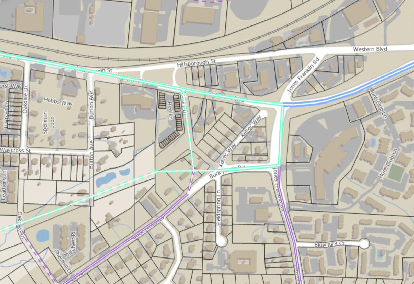
Western Blvd Extension not only runs behind the Buck Jones apartments, but also several large new student-housing complexes on West Hillsborough, and the cluster of multifamily lining Farm Gate Road. Hillsborough/54, by contrast, are lined with industrial buildings that arose along the railroad.
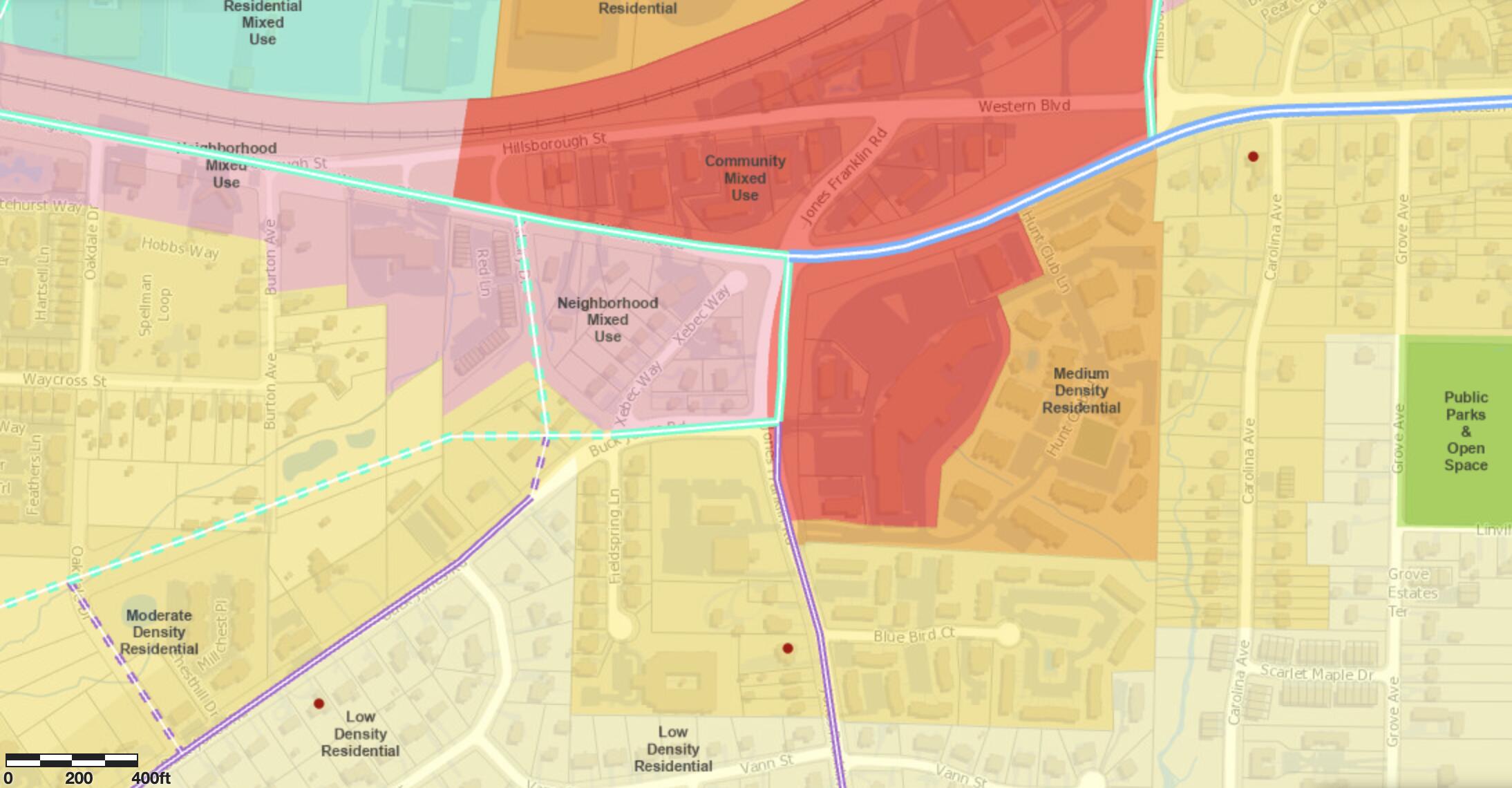
Cary would prefer a Chatham/Maynard/Cary Towne alignment not only to avoid having to widen the Walnut/Academy corridor, but also because its recent comp plan identified East Chatham’s light-industrial area and the Maynard MHPs for redevelopment. (I’d say this is a pretty fair example of expulsive zoning – exclusionary zoning’s equally evil twin.) https://www.townofcary.org/home/showdocument?id=14240
I’ve always heard rumors of the Western Blvd connection being made so not surprising this is being brought up. I wonder how that Western & Jones Franklin intersection is going to get redesigned to accommodate this with Buck Jones there close by as well (or is Western just going to tie into Buck Jones?)
EDIT: purple roads are 2-lane (1 per direction), green/teal roads are 4-lane, and blue is 6-lane.
Dotted lines, obviously, are the planned roads that don’t exist (yet?).
I think the jog is a mistake and I hope they reconsider.
I think it is a misguided attempt to create a street grid in that area but that is a goal that could be better achieved while keeping the Western Blvd extension as a straight through movement.
Exactly my thoughts. Like @orulz said, trying to force a grid around here is an awful idea because of just how car-centric and inefficient everything is laid out, around here.
And that’s just from a Sim City/Cities Skylines look at it, too. I visited a close friend a few years ago who lived around here -and when we walked or drove around, I kept noticing the old homes, the barely-maintained apartments full of students who can’t afford to live closer to campus, the Harris Teeter that’s poorly lit and looks almost decrepit from the outside, and the rush hour traffic jam at the awkward twist from Buck Jones to Western.
The way I see it, we’re screwed into picking 2 out of these four things:
do nothing different from existing plans -or- build something that doesn’t make traffic flow any better
introduce a grid or roundabout system that makes sense
kick out several dozen families out of their homes (and hundreds more pressured out from real estate tax spikes they can’t afford)
spend even more money to buy out the island of parcels sandwiched between Western Blvd. and Hillsborough St.
Agreed, I think the jog is a mistake. If we are going to make BRT a priority in this area, we need to make it so Western Blvd is a direct connection. I agree with your concept that we can avoid this if we take Hillsborough/Chatham along the northern part of existing Western and tie it into near where Hillsborough from the fairgrounds intersects with Western today
I prefer direction connections between Western (new and old) and Hillsborough. A grid that sets the stage for a more walkable neighborhood should also be a priority. This should include open space, perhaps as a ‘village’ square. And each suburban-style student apartment development is a huge missed opportunity.
Any intersection this complex is always going to be a challenge. It’s not just a five-point intersection, it really has eight legs: NC 54 west, Hillsborough east, Chatham west, Western east, Cary Towne west, Buck Jones southwest, and Jones Franklin southeast. The usual neat solutions to these (thinking of the eternally cursed Seven Corners in Fairfax County) have a large percentage of through traffic on one route that can be grade-separated, or have easily paired-off legs.
Anyone else remember the flyover? Apparently, it was built back pre-Beltline, when US 1/64 went over Hillsborough and Chatham.
The less-than-obvious problems are listed in the slide comments (download PowerPoint to view).
Other important problems include...
It also doesn’t help that the city’s future land use plan all but assumes that Hillsborough St. will be the BRT corridor. You’d think you would want to make TODs viable by making all of your potential BRT corridors mixed-use (especially when you get to build an entire new arterial). …except we got this:
Then there are the small, red dots for Supportive Housing Residences nearby. Survivors of abuse, people with disabilities, and/or people recovering from substance abuse live in these places and get the help they need in get back on their feet -in other words, people who probably have enough going on in their lives, and may not have the time or means to push back against some obscure planning projects that may or may not kick them out of their homes.
Ah, my bad, that’s supposed to be a large roudabout-y sort of layout. I just edited it to make that a bit clearer.
Personally, I think that one or the 3rd one (the compact half-loop) works best for development and BRT -but they may still have fatal flaws. Those are the least robust to increased traffic from Buck Jones and Jones Franklin towards downtown Cary, and it’s not immediately obvious to us non-professionals if that’s something to be worried about.
What if the only way to find a way out of this mess is to re-do the old Jones Franklin area study @pierretongmentioned earlier? I know “studying to death” is a problem, but the 2011 report assumed that Raleigh would have light rail running next to NCRR. Since that’s no longer true, its proposals just don’t make sense anymore.
I think there are definitely some fatal flaws with the last 2 concepts but given that I know little about the daily traffic patterns in that area and have no idea how much new traffic would use or be diverted to the Western Blvd extension, I can just speculate hypothetically haha
My favorite is probably the 2nd one which really just modifies the existing the area study concept so that Western is the direct connection. But again, who knows haha
Western BRT study page has been updated with some videos. Updated info includes the final corridor selection (with some background), and the eTOD guidebook.
There’s a survey link, which doesn’t work yet, and a mention of a late September virtual public event. Draft report due EOY, at which point initial design will start.
A slightly more analogous intersection in Fairfax (City, not County) might be Fairfax Circle, which is pierced by one major through route. https://www.fairfaxva.gov/government/public-works/transportation-division/current-transportation-projects/fairfax-circle-intersection-improvements
The way to make a circle work here would be to reduce the intersection offset – funneling the NC54/CH Road traffic via the long-planned Jones Franklin extension would help, but would require an expensive railroad bridge. The other wrinkle is that it would probably require taking a few of those little commercial buildings in the middle of the intersection – some of which have been there forever. (The Family Car Wash, Rising Sun Pools, and West German Garage all date to at least the 1980s.)
In theory, a TIF for the entire area could easily support that (new buildings around the intersection would pay to buy out the buildings inside), but that’s a lot to pull together in advance of the BRT.
This was added to the Western page; mostly “redevelop-able strip malls are Urban Design Opportunities, and it’s tough to cross the street to get to Dix Park.” There are a bunch of potential side-street connections shown, though I’m not sure what leverage the city has to make them happen. Recommends removing the Dawson/McDowell parclo interchange. No grand plans to realign BuckJonesFrankWestHills.
Hint: widen your browser window to full-width.
One thing I hadn’t seen reported before: the cheapo Blue Ridge Cinema is definitely no more. The site’s tagged as “apartments under review.”
You’re right; a lot of the infrastructure improvements came out of nowhere. The city does have the right to make its own streets and things, but City Council almost always wants new roads it in their city street plan, first, so something’s not right.
It’s not just the side streets. The assumption that BRT will connect at Wilmington St. (even though they haven’t formally chosen that over a McDowell/Saunders route, yet), Dix Park will have a land bridge,… the fact that all of these features are on this map makes me think one of two things is happening:
This website is just eye candy; you should take it with a grain of salt.
This is a sign that the Western Blvd. BRT might take a while to be planned.
What do y’all think? Am I just being cynical, or… …?