Commuter Rail - Garner to West Durham

@keita Oops. I think I might have been less than clear in my comment. It’s not Raleigh-based, but it has an impact on what we’re hoping to achieve.

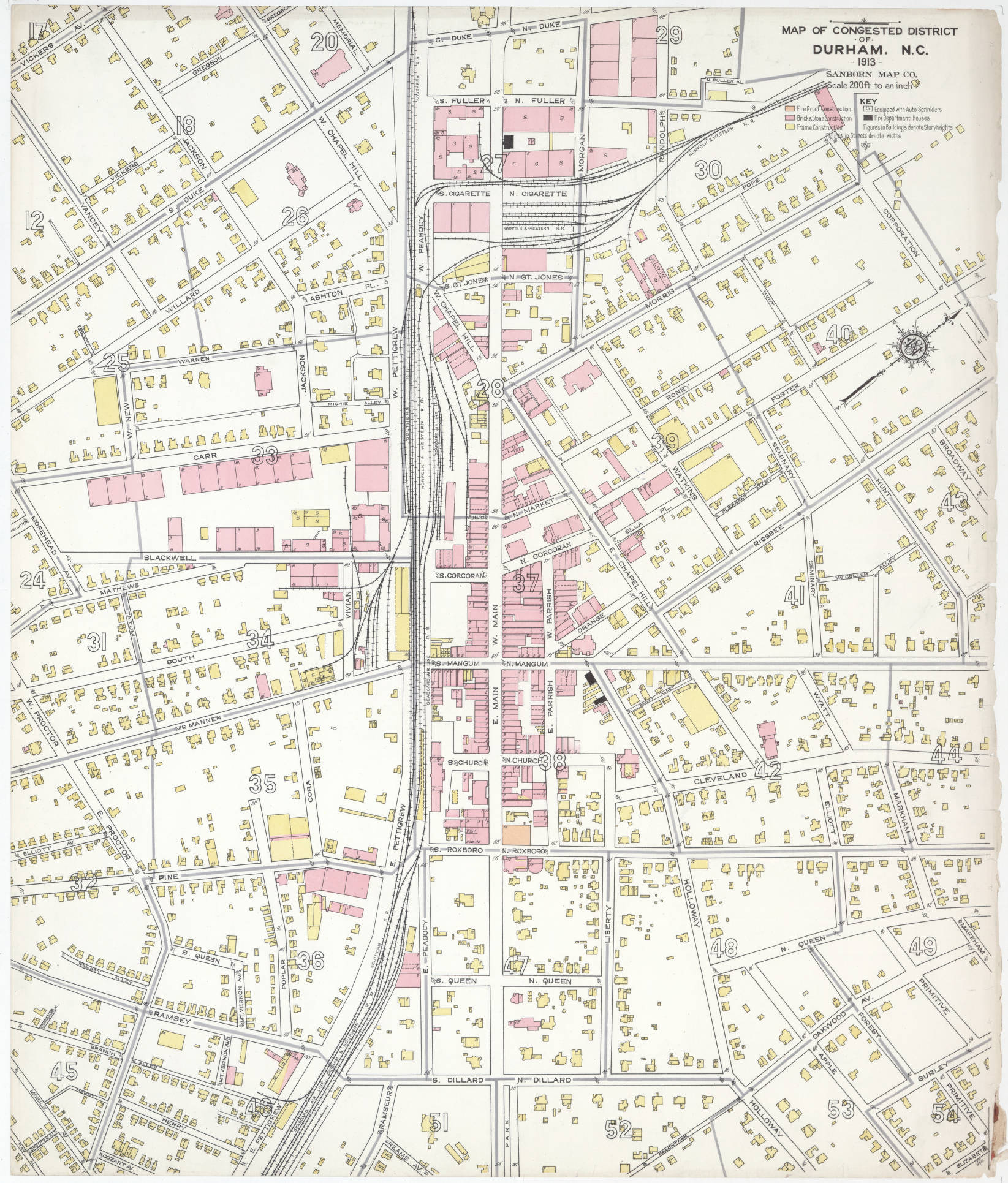
As I have noted elsewhere. Durham had five different freight (and passenger) railroads converging on it because of the competition from the five major tobacco processing plants.

There is the NCRR from Goldsboro to Greensboro with operating license to the Richmond and Danville Railroad/Southern Railway/Norfolk Southern Railroad. The Southern Railway also had another route into Durham, the Oxford & Clarksville Division extending down from Keysville VA through Oxford to East Durham (which can be seen from I-85 heading north across Falls Lake). The Seaboard Air Line Railroad ran from Henderson to East Durham from Creedmoor terminating in downtown Durham. That line was largely abandoned when I-85 was built, and a middle segment was flooded with the creation of Falls Lake with a remnant left from Joyland Junction to East Durham running parallel to the SOU’s Oxford & Clarksville Division (two parallel railroad tracks seen over US 70).

The original Norfolk Southern Railway had a spur running into south Durham from the NSRy main line at Bonsal. The middle portion was flooded with the creation of Shearon Harris Reservoir. The northern segment is the American Tobacco Trail. The southern segment is operated as the New Hope Valley Railway. The Durham & Southern Railway came up from Dunn in to East Durham and sharing trackage rights into downtown Durham over the Seaboard Air Line. The fragment from East Durham to Apex still survives. The Norfolk & Western Railway came down to Durham from Lynchburg VA by way of Roxboro and Bahama making a belt loop around Durham.

Needless to say, it was a congested mess:

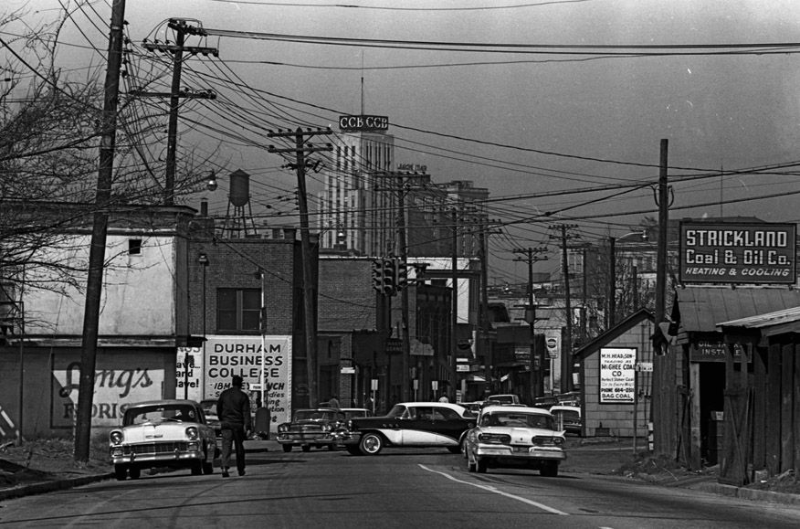
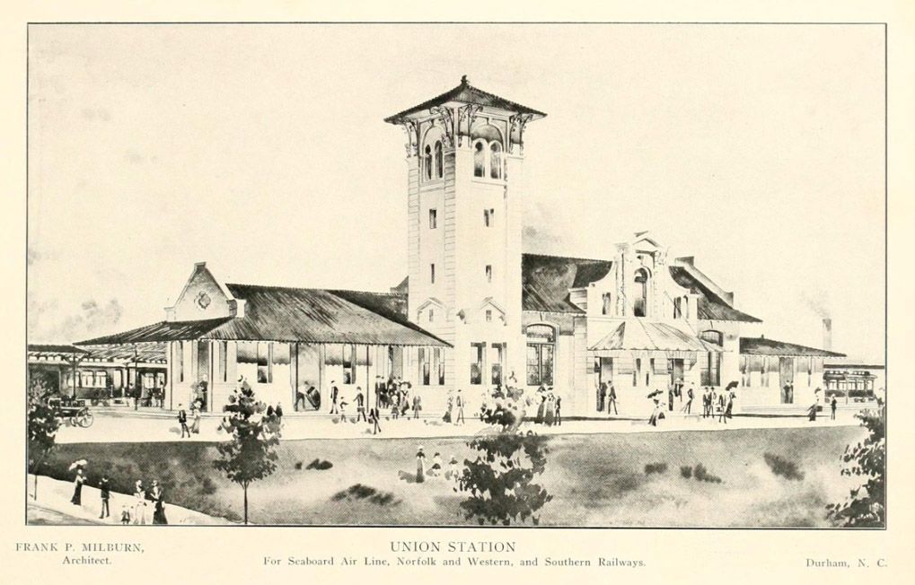
The creation of Durham Union Station in 1905 helped consolidate passenger operations of the major carriers, but each of the companies had their own freight facilities. (pretty picture time)


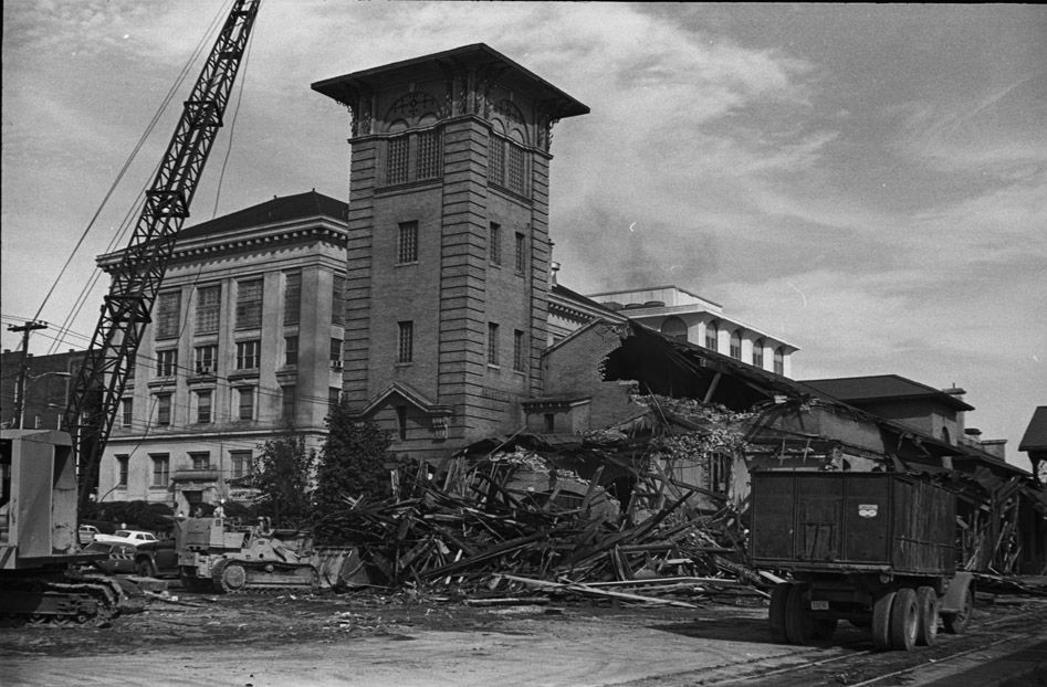
As with other cities dealing with the contraction and decreased influence of railroads, so too did Durham, tearing down Union Station in 1968.

A large portion of the area between Pettigrew and Peabody streets saw the tracks abandoned and the Durham Loop was created in their place. As you noted earlier, this coincided with the construction of NC-147 and the destruction of the Hayti neighborhood. Hickstown was preserved, but relocated.

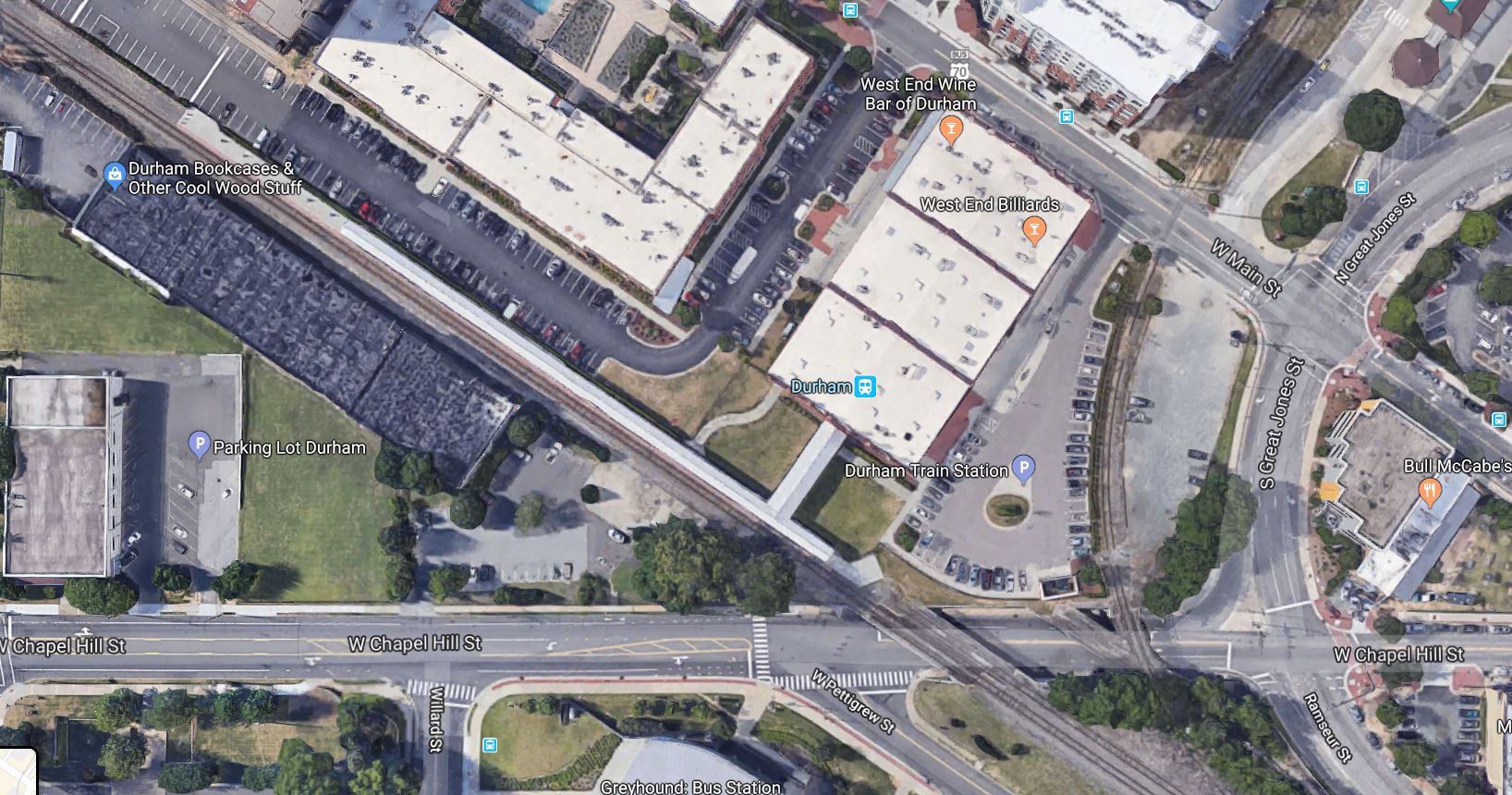
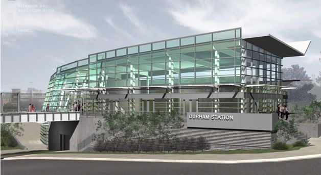
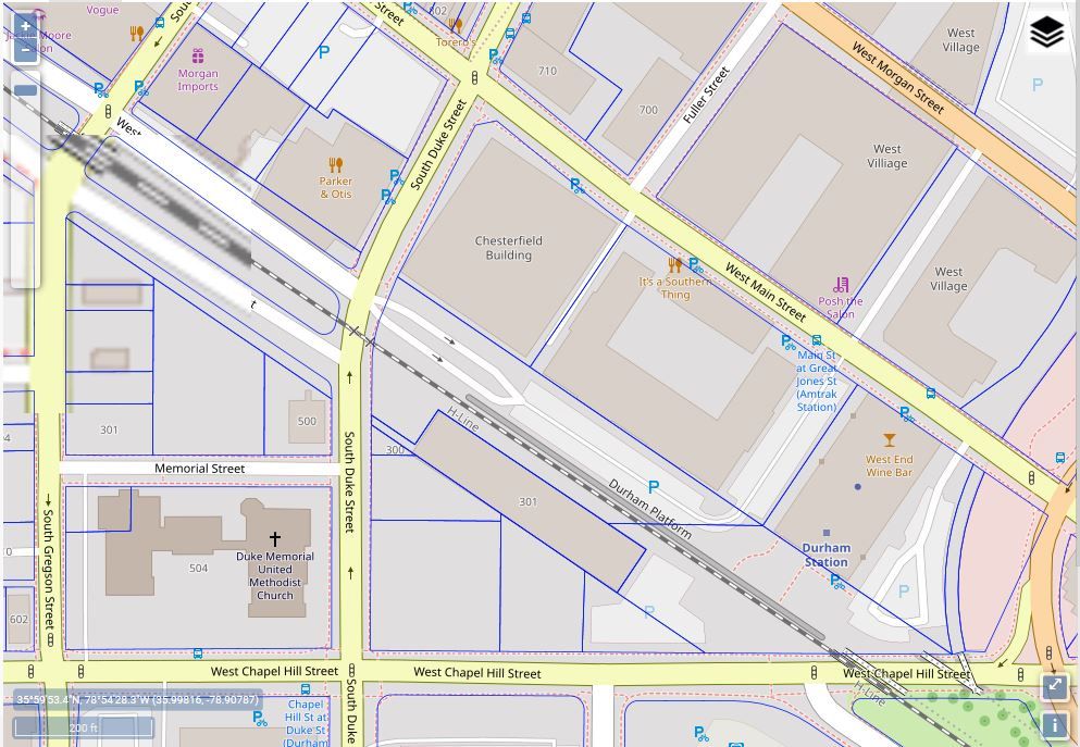
Amtrak’s intercity passenger operations were moved to the Walker Warehouse in 2009. But, it is constrained by the fact that it is in a single-track segment of the NCRR with no room for double-tracking or creation of a house track. That’s going to be a problem with the increased traffic which will be generated by the commuter operations from Garner to West Durham. And, it’s going to be even more tricky as the NCRR and NCDOT start moving their corridor sealing to Durham County.

There are at least 13 grade crossings on the NCRR in Durham County. Two of which, Mangum Street and Blackwell/Corcoran, were many parts of the failure of the DOLR project.

Thinking big picture, my thoughts were to depress Mangum, Blackwell/Corcoran, and Pettigrew as a rebuilding project of the Durham Loop and eliminating those conflicts. Then, one could build over that traffic trench with tracks and a new Durham Union Station at Mangum and Pettigrew. Big $$, I know. But, a good way to solve the many conflicts.

Back to the original confusion. The Durham Belt Line trail is being recycled from two segments of the N&W loop track.

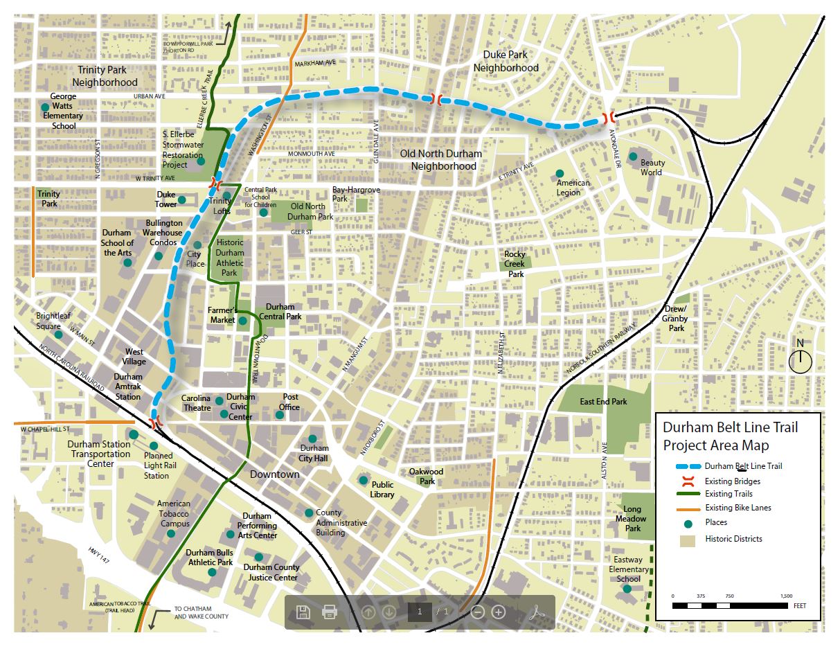
As the middle portion of the original Norfolk & Western spur from Lynchburg was flooded with the creation of Hyco Lake and the building of Duke Energy’s Roxboro Steam Electric Plant, Norfolk Southern can’t reactivate that line. The Oxford & Clarksville SOU segment is largely abandoned with tracks still in place north of Oxford. I can see why NS conceded these resources to Durham. So, they will likely stay as a trail, once instituted.

6 Likes

One would suppose that the alternative is to tear down the current platform at the Walker Warehouse and re-installing the second track which was taken up to build the platform in the first place. Then, rebuild it as a high-level platform a little closer to the warehouse. So, one house track re-delivered.

But, that’s not nearly as sexy as re-imagining the Durham Loop as a dual-level carriageway - two way automobile traffic below and rail traffic above. (And, the cheaper option would also take out a row of parking spaces which would piss off more than a few folks in the neighboring structures.)

1 Like

While riding the Piedmont through Durham about two weeks ago, I noticed that crews were tearing up the abandoned tracks across Chapel Hill St. leading to the Belt Line.

1 Like

@Christopher Had heard that was moving forward. My rehearsals at the Durham Arts Council have been on summer hiatus, so I’ve not been over that way since April. Will see what happens in two weeks when we start back up again. Thanks!

1 Like

Make the existing platform an island platform. Build a tunnel under it for access like at Raleigh Union Station.

The people who would be upset over losing a few parking spaces can cry me a river. That parking lot is on railroad property.

2 Likes

@orulz Hehe. That’s the spirit!

I imagine that somewhere in the contract for the neighboring tenants there is probably an eminent domain clause warning them of a possible loss of that parking strip. They will claim ignorance, of course.

Two sticky wickets at that location. Needing a house track and also the eventual grade separation at Duke Street.

Then, there’s going to be the FRA requirement that all stops be ADA compliant. $$$

1 Like

I think you need at least a three track layout, ideally four, where the platforms are on the outside of the outer tracks and the inner track(s) allow for freights to pass unimpeded.

@CanesFan Unfortunately, the Walker Warehouse site is a little constrained for three tracks. Moving back towards Mangum has the larger potential right of way. But, serious grade separation is going to be needed because of all of the new development at DBAP and DPAC.

1 Like

Durham Station and the Walker Warehouse are only a constrained location if you assume the parking lots north of the tracks and the one-story brick warehouse south of the tracks must always remain where they are. As I mentioned before, they are all on railroad property, and the corridor is 200 feet wide. RR property extends up to the walls of the warehouse buildings facing the tracks. In addition, GoTriangle owns the triangluar parcel south of the tracks bounded by Duke, Chapel Hill, and the railroad.

It would be quite possible to fit four passenger tracks and the platforms to service them, plus a fifth track as a bypass for oversized freight, through there. This is with 17’ track centers, a 30’ wide x 1000’ long island platform, and two 20’ wide x 600’ long side platforms.

The only thing that’s lost is the parking lot, which is explicitly a temporary use and built on RR property. The lost parking could easily be replaced by building a parking deck on part of the triangle-shaped parcel owned by GoTriangle across the tracks to the south. Parking for the station is needed, anyway, so why not include spaces for Chesterfield, etc there as well?

IMO this should all happen as a part of a project for RR grade separation downtown. Previous plans would have only separated Blackwell and Mangum, and raised the height of the Roxboro crossing, but really they should be looking at separating Duke as well (as you mention), plus fixing the clearance at Gregson and Chapel Hill.

Trenching the RR would probably yield a better overall result if funding can be found, but that would be expensive. Personally I’m fine with raising the RR and lowering the streets where necessary. Perhaps Durham can put some of their transit sales tax money that the light rail’s cancellation freed up towards this project.

3 Likes

The original plan for Durham Station was to build a bridge between the platforms and the bus terminal across the street.

image
Original image of the station concept at Durham Transportation Station | Open Durham

If I understand the proposals right, the bridge would span the yellow lines here:

It sounds like that sort of rail-bus connection is already supposed to happen. I just wonder what happened to it…

This is already an assumption NCRR has in their playbooks, since like you said, they already own the right-of-way for it. If anything, this was why they kept refusing to let GoTriangle build light rail next to Pettigrew St., causing all the problems about the Blackwell St. intersection (one of Duke’s complaints that broke the camel’s back). I think it’s a problem of when, not if, for the rail owners.

3 Likes

@orulz Right you are (I hadn’t navigated Durham’s GIS site before).

1 Like

Originally, Amtrak was going to go into the Durham Station building. I think that it took too long to get the Durham Station project moving (at least two or three iterations of it) and Amtrak wanted a new station badly. So, they pulled out of the Durham Station project and went to the Walker Warehouse.

3 Likes

Fair enough. With the Cornwallis Road grade separation, that makes it the next of probably 13 that are going to need to be done.

Second…

Third and Fourth…

Hi everyone, do we need to rename this thread "The Future of Transit in Durham? :upside_down_face:

7 Likes

LOL - I just had the exact same thought.

1 Like

@RobertSanderlin @Kanatenah I’ve tried to be mindful of the thread. At the same time, our commuter rail project will start here, and end there (especially with the death of DOLR).

And, the premature loss of the creative minds behind RUS and Durham Station ironically so close to each other timewise. Steve Schuster and Phil Freelon.

4 Likes

I was thinking the same thing since I posted this topic. I never said anything about Durham at all.

The link doesn’t work for me. Any chance you could provide another? I’m very interested in seeing what you’ve drawn.

Somehow the link was corrupted… probably my doing. Fixed it in my post above.

1 Like

Bull City Baby!!

4 Likes