Reedy Creek Road is better than Harrison.
The ultimate route between the downtowns is Walnut Creek:
Would also require Raleigh to finish a trail from Lake Johnson (Jones Franklin end) to Buck Jones.
Reedy Creek Road is better than Harrison.
The ultimate route between the downtowns is Walnut Creek:
Would also require Raleigh to finish a trail from Lake Johnson (Jones Franklin end) to Buck Jones.
I’ll jump on this. It’s kind of wild that this bridge was torn out with no plan for replacement. The reality is people are going to get on Ebenezer because it’s the only work around. I’m curious what the timeline on this is going to look like, because this is a very well used trail.
Try this route from DTR train station to Cary Station -
I have done that route a few times and find it pretty safe. I utilized the greenways whenever possible.
The triangle has the best greenway on the East Coast in my opinion. Here is a greenway map with
*all the greenways in Raleigh, Cary, Morrisville, Durham and CH
*all the bike shops in Raleigh, Cary, Durham
*all the remote bike tool stations in Raleigh and Umstead
*this map is built on google maps, so all restaurants, bottle shops close to the greenway are also listed
*including Umstead and the ATT, the triangle area has about 275 (!) miles of greenways, and they are constantly being improved.
*feedback to improve the map is welcome
www.bit.ly/ncgreenway
I would like to rescind my props for the crew that’s working under 440 and the Crabtree Creek Greenway. I’ve been meaning to post this, but the work was originally mentioned of having a completion date of July.
Over the past few weeks I’ve been biking through this area at night and having a few shout at me which normally ends up me just passing and ignoring them. Last time they pretty much ended up blocking section again. I ended up riding on Glenwood since it’s more of a direct route to my place.
Separately. Did a bike ride from Ponysaurus to Sneaky Penguin and back. We took Atlantic Ave. to the greenway, but pissed off a few people when we came to a stop to get onto the greenway (there’s a curb).
Overall the ride was nice.
I biked on Crabtree Creek under 440 today and it was open, but lots of equipment still parked there.
They’ve been closing it off starting around 6:00. I’ll use it for commuting from/to work which is part of when I’ve been riding and them not being happy about it. During a group ride, we rode through there about the same time and also ran into the same issue.
I’ll just say as someone who has worked in utilities, if someone rode their bike through an active job site that I was working on I would be a bit frustrated too. It’s unsafe for the biker as well as for the workers in the area, especially if the area is barricaded off and you aren’t expecting someone who isn’t actively working on the job site to come through.
Unfortunately the way it’s set up is set up to frustrate someone because there just aren’t good detours and yet maintenance still has to happen. It’s really a no win situation.
Lack of good, safe detours is a serious issue. See my post on this from a while back.
Yeah I agree, and I had previously read your post you linked, I’m just offering my experience. My utility work has been on the NCSU campus and dealing with students wandering into jobsites was a constant issue. It really was extremely unsafe not only for them (which I guess they could be like “I accept this risk to myself”) but also to the people trying to do the work.
I don’t think that when the greenways were planned anyone thought they would be used this heavily, otherwise surely someone would have thought about detours earlier on.
Look on City web site for project manager. Yes, there is lack of communication between Utilities and Parks. Most greenway trails would not be there if it wasn’t for the sewer/flood plain area.
If this is really the case, which fine if it is, then the Greenway plan needs to be adjusted to account for this. Capital Area Greenway Plan Link
The main concern I have when it comes to Greenways, or bike lanes, is that having a non fully functioning greenway or bike lane system leads to a limited amount of use. The limited amount of use can then lead to a perceived “waste of money or space” and then further leads to less investment and potential removal.
From the Greenway Plan:
Since the Greenway Plan tends to mention the use of commuting, I would like to see actions that move towards the ability of the greenway to be used for consistent commuting. This means providing detours that don’t add a 100ft incline hill in which the incline goes up to 19% (Crabtree Creek/ 440).
Direct access:
Detour
On a separate note, I have noticed when biking is that newer trails that are getting put in still have flooding issues. A few weeks ago, I rode on the realigned section of Crabtree Creek just east of Raleigh Blvd. This trail was re-aligned, but still suffers from flooding. To get through, I ended up doing half pedal strokes to keep my feet from getting wet. It’s disappointing because the trail project in this areas is close to being completed, but still lacks functionality. This shows that newer Greenway projects are lacking and are not taking into account heavy rainfall.
Below are some photos from my rain commute. I’m not stating the photos below are indications of bad conditions. They are more to show that am someone who does commute during rain events.
Left: Newer section of Crabtree Creek Trail just South of 440.
Center: Under Glenwood Avenue. There are times where the bridge is covered by water and not passable at all.
Right: Tree down on House Creek Trail just west of Marshall Park Apartments. I found a detour that took me through the Tennis courts. The tree was cleared out quite quickly.
Some unrelated photos/topic to commuting. I took a leisure ride up to Honeycutt. I found that the sidewalk is finally getting some work done to it where it was collapsing.
My wish would be that we can actually make this into a full sidepath instead of the existing 5ft sidewalk. In the photos, we can see that the traffic had been shifted over one lane for construction. Even putting in a 2 way cycle track on this section to connect both Newton to Longstreet would have been nice. I don’t really see why we need the median lane.
Similar to my other talks about detours, we can see in the left photo that a sign simply stating “Sidewalk closed” was place. I’m not sure where they are expecting people to cross to the other side of the road. There’s no traffic light on Longstreet or crosswalk.
Greenways have been under the purview of the city’s parks department since the outset of the greenway program in the 70s. Note this means they are not managed by the transportation department and are treated as such: recreational amenities rather than transportation infrastructure. The city’s policies consider them to be important and worth spending money on, but do not treat them as critical infrastructure, unlike sewers or roads.
It would require a major policy to change this, but I hope the city considers doing so, even if only for a subset of the greenways around town.
Given that these areas are in forested and floodplain areas (natural sponges), it’s smart to allow these areas to flood but not to the point that the infrastructure is damaged or destroyed. This does mean that more management and maintenance is needed over time.
The park in Cary was built to imitate this natural process but to a certain point. If you raise an area that needs to be a sponge, other areas with critical infrastructure will be at risk.
As Orulz & true urbanist stated these trails are in the floodplain. They will flood. The goal is to get you close to nature. But the main use is sewage conveyance. That section under 440 near Glenwood has 3 major sewer mains with the new 54" sewer main so everything (waste wise) from Brier Creek to Strickland Road/Six forks flows through those lines. The goal is to keep it in the pipes. They come first. There are no easy detours and I know your pain as I have biked up that hill to North Hills Park. Permitting in the flood plain is a long and tedious process. Yes, I wish we had better multi use trails along the ROW as alternate routes but the Greenway system has come a long way. Thank Vic Lebsock next time you enjoy the greenway.
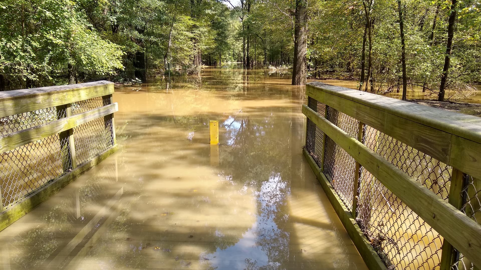
I get the frustration about flooded greenways. From earlier this week, before Helene:
This is essentially the reason the city can’t just raise the grade of greenway paths:
That said, some work is being done to relocate sections of the WC Greenway to mitigate constant flooding and infrastructure damage.
Oh, wow. That’s fantastic news. I totally agree about that being some of the roughest stretch of the trail. It’s full of pinch points. If the city can reroute the trail as depicted in the map, that would be awesome.
Wet wooden bridges are like ice skate rinks. I slid out today on the ice and got some good road rash.
Today’s commute:
More or less of an update on how the Greenway looks.
1st photo: just North of 440 and Crabtree Creek Trail
2nd photo: Crews cutting down the tree on the bridge near Marshall Park Apartments.
3rd photo: This is a different view of the tree when it was down on Saturday. I used Blue Ridge Rd as a detour.
Props to the Greenway team for clearing it out.
Sad that this happened. Greenways in this area feel super sketch. Its frustrating because i emailed the city a while back to do volunteer rides for the police department but never heard back. Just the sense of an increased presence could bring more folks out or at least peace of mind for the ones already biking. I know plenty of people who wont bike this area or downtown from south raleigh for safety reasons.
That’s so sad. I’ve run that exact trail at that exact time before.
Hard to think of what exactly the police could do more to stop a random daytime attack. Is a cop riding by once every week or so really going to stop that sort of thing?