Claude pegs the project costing between 100M-175M fwiw
2 Likes
Yes, this is expensive, but I think this would actually be peanuts when you look at the economic impact a project like this would inject into a city. Immediate property value increase across all properties with walkable access, private development (apartments, townhomes, office, etc), tourism. I’d safely bet this project would ultimately pay for itself with those numbers in tax revenue.
13 Likes

2 Likes
If done properly, this could be a game-changer for Downtown Raleigh. Turning the much-needed connection between Dix Park and Downtown into an attraction is such a great idea.
If this can actually be “level, continuous, car-free and shaded most of the way,” as Sig Hutchinson suggests, it could be very popular and finally give Downtown that elusive reason to come downtown. The N&O article references the Highline (which is the first thing I thought of) and Atlanta’s Beltline, which are both great. I haven’t been to the Miami Underline.
I assume the developers of City Gateway will seek to activate their portion of this by offering abundant food and beverage options.
Once you get Downtown, there needs to be easy wayfinding and an easy way to get to the new Red Hat (which, IMO is looking so good already). Hopefully it would then help give Fayetteville Street a much-needed boost as well.
It seems like this is already being considered more seriously than the gondola, which is an idea that lots of people like but never got past the very basic conception phase.
Let us know how we can support this proposal. I imagine almost everyone on this forum would be a strong advocate for this if it continues to develop towards something that may actually get built.
Edit: A few other thoughts: I like the name. If this could tie into The Grove at Dix Park (which is full of Oak Trees) it would be a real boost for the name and brand. Also, the next phase of Dix Park is the restoration of the Rocky Branch and tying the planning for this into that would be fantastic, building further connectivity.
25 Likes
Yes – and for those who needed another reason to like Mitchell Silver – the closing lines from the article are:
The challenging road ahead is not stopping Silver from championing the Dix Park connector.
“It’s been one of my top five priorities,” he said.
12 Likes
The TBJ piece had a few details that I don’t think I had seen before:
- The estimated cost would be $90 million, and the project would need funding from the federal, state and city levels, as well as from private investors, according to Silver
- Not surprisingly, the timeline is “several years” with actual construction taking 18 months to two years.
- This explicitly states that it would connect with the Rocky Branch greenway. I thought it would based on the location, but it is good to have that confirmed. The Rocky Branch restoration is likely also a few years away, so maybe they could both be opened around the same time.
8 Likes
Any private investment planned for this since it connects to the City Gateway project?
Can we just rename this Thread “Downtown Strollway & Oakline Projects”
Also, I believe that these two projects, Triangle Bikeway and the other bike/ped safety projects associated with “The Big Jump” are going to solidify Raleigh’s reputation as the “City of Oaks”.
These projects will help the City slowly adapt to our new environment that will continue to cause flooding events and heat island effects to become more extreme, but also improve air quality and increase connectivity.
6 Likes
Does the Strollway compete with the Oakline for funding? If so, we need to go ahead and scrap the strollway
2 Likes
I was thinking the same thing. I like the idea of the Strollway on it’s own, but I think these 2 projects serve the same need. And I would much prefer the Oakline over the strollway if it is an either/or type of thing.
2 Likes
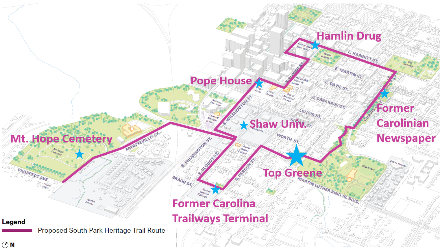
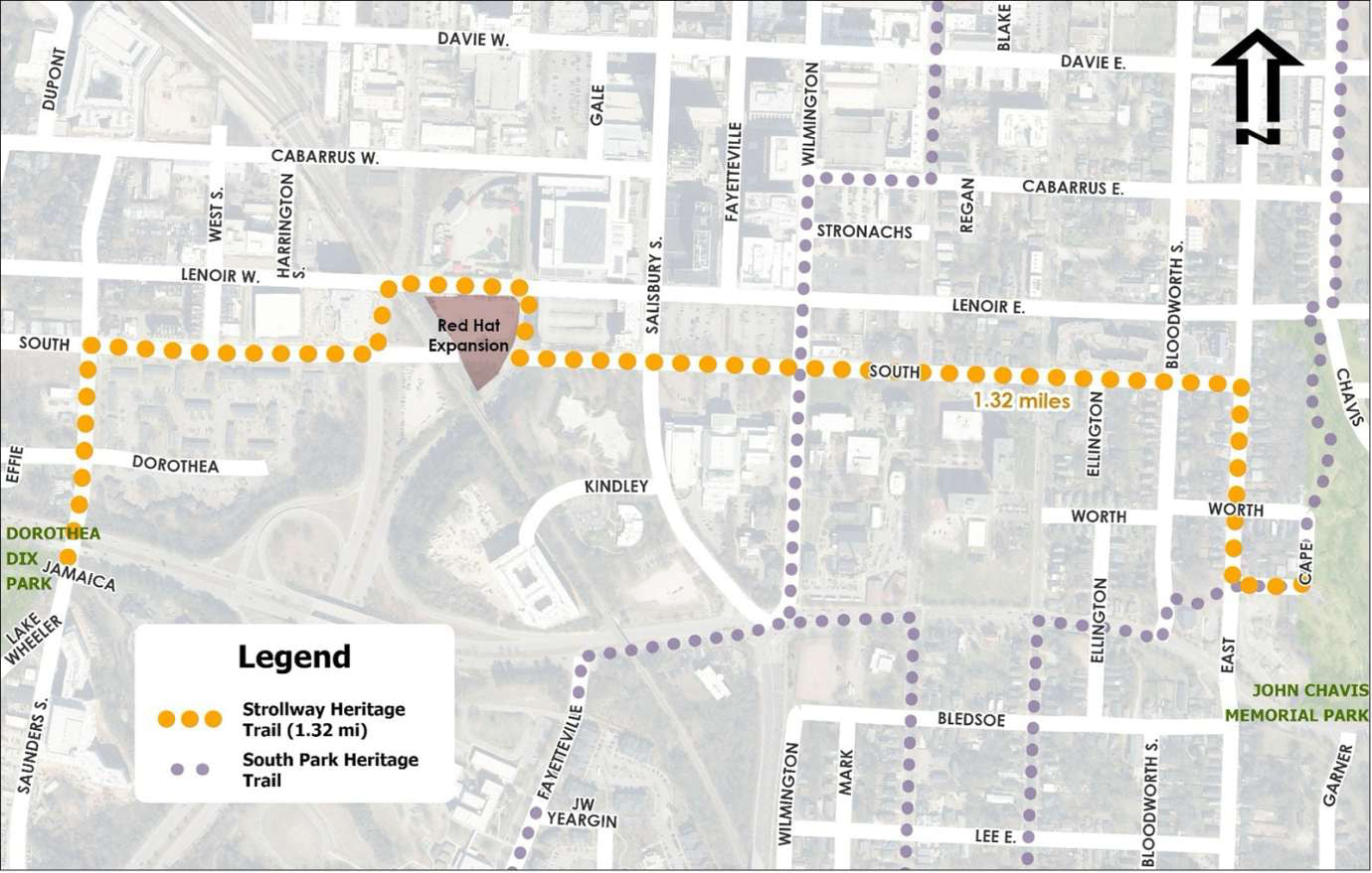
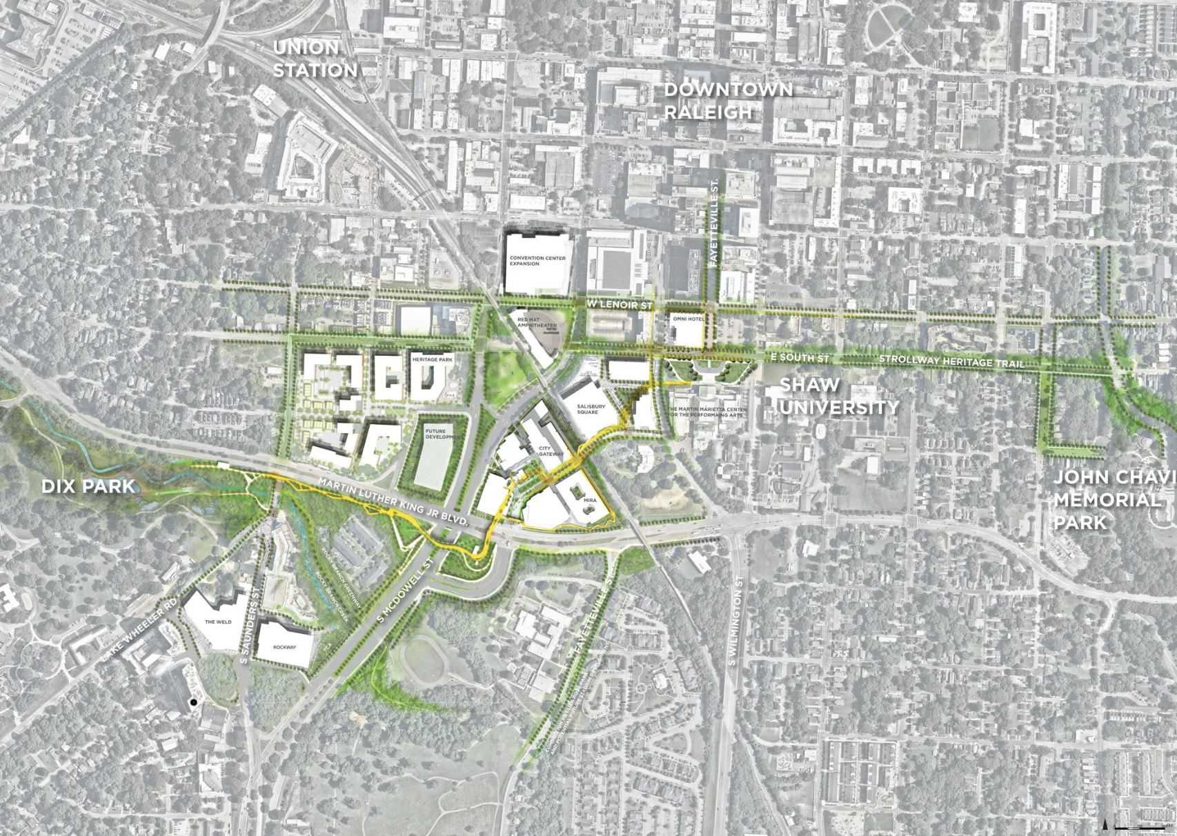
The Strollway, Heritage Trail, and Oakline all seem to be somewhat competing projects, while also being very complementary to one another. From what I understand, the Strollway currently only has about $1.5 million funded for design, the Heritage Trail is fully funded, and the Oakline is still TBD.
It seems like there could have been a real opportunity to better coordinate or combine portions of these projects, leverage the available funding, and ultimately get more actual infrastructure built rather than having three separate efforts moving forward independently.
It looks to me from the maps that there could have been a good opportunity to overlap and connect. Examples:
- Instead of Heritage Trail going on Cape Ave it should have kept going straight from Top Green down South St and took a right on Lenoir to connect with Chavis Way. We already have a greenway trail on the heritage route through Chavis Park. This would construct part of both Heritage and Strollway.
- The large Heritage Trail Fayetteville St section could be adjusted to merge into the Oakline with access to that Fayetteville St area and Mt. Hope Cemetery creating a connection off of the Heritage Trail.
- I would have pushed the leg from Pope house → S Wilmington St and instead connect to the Oakline from Wilmington → South St. → Salisbury → Kindley and finish out the route back into the Heritage Trail through the Oakline.
10 Likes
This really does nothing for people who live in the South Park area just south of MLK Jr Blvd. MLK Jr is basically a massive barrier to pedestrian activity, even with this strollway. MLK Jr Blvd needs to be revamped with way, way better pedestrian facilities, better sidewalks, pedestrian islands, etc. I guess we still have to wait for the BRT plans, whenever that is suppose to happen. With all the new apartments south of the street, there are a lot more pedestrians crossing now. It’s only a matter of time before pedestrian deaths on MLK Jr Blvd start to climb.
5 Likes
I 100% agree. It’s extremely unsafe to cross, walk beside, etc.
My concern here is that we have 3 projects running in parallel. If we have focus split with competing goals we are likely to get 0/3 in the next 10 years.
6 Likes
I agree too. This echos my comments for the strollway and heritage trails whenever they do a survey or ask for feedback. I will say they do have other projects in the works for improving MLK Blvd for pedestrians. The City lists the project scope here. First one is Blount to East section:
HS-2405T: Blount St to East St
- Blount St: signal upgrade, curb ramps, high vis crosswalks, guy wires, and curb
bumpout - Person St: signal upgrade, curb ramps, guy wires, and curb bumpout
- Ellington St: curb ramps
- Bloodworth St: curb ramps
- East St: Signal upgrade
a. Curb ramps and high visibility crosswalks will be constructed by E051-092-25-
01223
6 Likes