While trying (and failing) for the 30th time to come up with a Raleigh-Durham rail alignment that both hits the RDU terminals and doesn’t suck in every other possible way, I did come to realize that a world-class HSR line for the North Carolina Piedmont Crescent is actually not as hard as you might think.
By combining together some segments of the existing RR, power line easements, highway rights-of-way, and a few rural greenfield segments, you can get a HSR line that could go from Raleigh to Greensboro in something between 30-40 minutes.
With the exception of 6 miles through central Durham and 5 miles through central Burlington where the speed limit would probably be under 100mph, the speed limit could easily be 200mph for the rest of it.
There are a couple of tricky transitions that would have to be worked out. The worst one is getting from Wade Avenue to the NCRR through the NCSU vet school. Another one is just west of Burlington. Another one that would probably not be controversial but would be kind of expensive would be that the ROW would require acquiring and demolishing the Hilton Garden Inn at I-40/Miami Blvd.
Interestingly, There would have to be a short tunnel punching right through the center of Occoneechee mountain in Hillsborough.
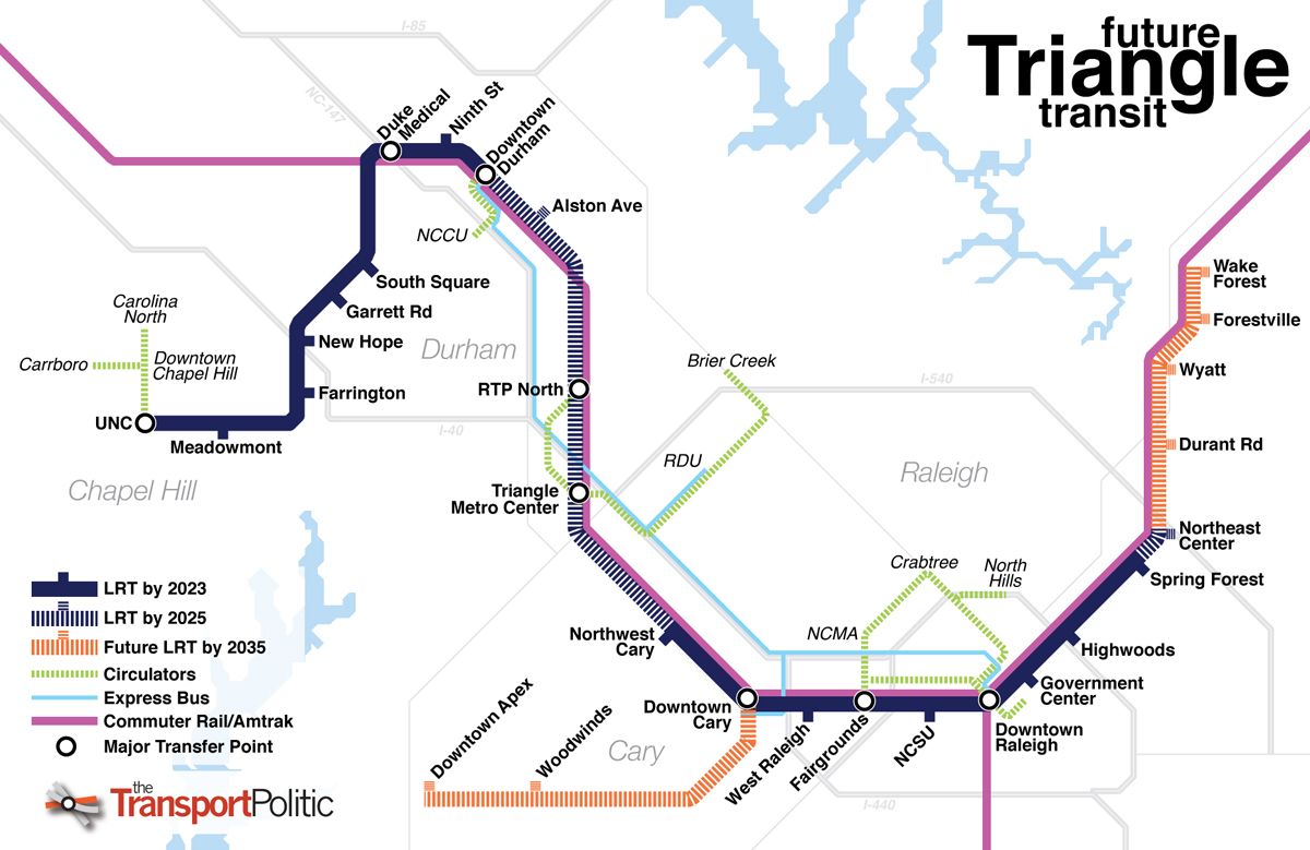
(Tacked on part of the proposed SEHSR alignment from Raleigh to Wake Forest just for kicks.)
I acknowledge that the route you have shown tries very hard to get everything but the only route that travels in anything remotely resembling a straight line is North Raleigh/540 to Chapel Hill, which is quite far from the most important route in the triangle. Not to mention that 540 is a poor transit route anyway since the only density anywhere near it is TTC and Brier Creek, which are 10 miles apart from each other, and are very dispersed and auto-oriented. (A Glenwood-440-Midtown route would be way, way better.) Meanwhile the Raleigh to Durham route is shaped like a Z and skips RTP. Not good.
Jarrett Walker is fond of saying “You can’t change geometry.” I think a corollary would be “You can’t change geography.” The geography of our region does not lend itself to putting RDU on a transit mainline from Raleigh to Durham. I wish everybody would finally realize this and own up to that fact: trying to make RDU a centerpiece of a fixed guideway transit system would be a horrible mistake. It is unfortunate, some other metros don’t have the same problem, and that may hamper our economic competitiveness compared to those other regions, and may mean that visitors to our area don’t get that coveted seamless plane->train experience, but THERE IS NOTHING WE CAN DO TO CHANGE GEOGRAPHY.
If we build a super high speed route along I-40 like I drew above, then I could maybe see adding a spur to the RDU terminals that could leverage the HSR infrastructure for direct express service to Raleigh and Durham. But that is decades off.
The whole reason that I posted this topic is the fact that traffic congestion will get worse and worse over time as the population in/around the Triangle grows just look at 40 and see. adding more Buses and a BRT is fine, which is why we need to discuss the option of Rail in the triangle area and not shoot it down.
Not only the Vet School, but NCSU’s private club (plus, possibly some disruptions around Meredith). This was an issue that gave some headaches for the planners of the upcoming 440 widening -and I’d imagine it could happen again here, too. I would love for a connector like your suggestion to be built, personally. But State’s vet school/animal research facilities are some of the best in the country, and disrupting anything there sounds like a fatal flaw to me.
Thanks for flagging this article. I’m glad he’s paying attention to this need, too, but… would General Assembly politicians still care about this? We’ve already finished a Tier II environmental impact study that showed it’s realistic, feasible, and a good idea to make a DC-Richmond-Raleigh-Greensboro-Charlotte high(er)-speed rail service. In 2017.
Despite this (funding is literally the only obstacle), no one seems to be consistently pushing for the SEHSR. I wonder if there’s anything we can do to get this back on the table?
@orulz isn’t even arguing against rail in the Triangle, though?? His suggestion -assuming you could pull off the power line and I-40 alignments- looks like a reasonable strategy, and it’s clearly a pro-rail idea, even if it’s not built off of a single blogger’s interpretation of an outdated plan from ten years ago.
His point is that going through RDU sounds awesome and convenient until you look at what obstacles you’d need to solve. That’s not close-minded NIMBYism; that’s a legitimate problem where, if you disagree, it’s your turn to poke holes or bring up counter-evidence.
No one here disputes that it would be a nice thing to have, and it would obviously be a super convenient amenity if you could hop on a train from any major hub in the Triangle to the airport. However, I think a lot of people here have made solid arguments about why a direct RDU rail link doesn’t make sense in this day and age -and I don’t think anyone’s brought up a watertight counterexample yet.
The vet school sits atop one of the highest hills in the entire city. One of these days I want to go to the top level of the parking deck there and check out the view- I bet it’s fantastic. But anyway, this is relevant because the HSR line I’ve suggested would need to be in a trench, or perhaps, a cut-and-cover tunnel- from where it leaves the NCRR right of way, until emerging in the vicinity of where it crosses Wade Avenue. It’s basically dictated by the topography.
Tunneling isn’t cheap, but of all the tunnels to build, it literally doesn’t get any easier than this. Cut and cover through mostly open terrain.
The impacts to the university club are minor (the corner of a parking lot) and temporary (because it would be covered over and restored after construction.)
There would be a few structure impacts at the vet school, but they are ancillary structures that would not be difficult to replace. The landscape could be easily restored after construction - just pile the dirt back on top and plant some grass.
I think the reason you’re not seeing much support for SEHSR is just politics. The Trump administration hasn’t really made mass transit a priority, and in the case of California they’ve sued to get funds back. An interstate rail corridor needs federal support.
On the State level, I think there’s some willingness to pursue it, but I think they know it’s a non-starter on the federal level right now.
Eventually we’ll have a president that believes climate change is a real thing, and regional mass transit will come back in to focus.
True; forgot about the terrain. I hope whoever becomes the project manager’s not as incompetent as the ones for DOLRT or Charlotte’s light rail, or else this would get twisted like a piece of yarn.
I didn’t want to just squarely blame it on politics, especially since it kind of seems like a black hole/boogeyman for things like this. But I guess there’s still something to be said about it.
I wish the state (through NCRR) would try to start a private-public partnership or help to fund a startup specifically for this purpose. But Tea Party/John Locke Foundation-powered legislators in the General Assembly probably wouldn’t be fans of that idea, either.
I would hope this could be a PPP between NCRR and NCDOT Rail (which do seem especially competent at both project management and navigating treacherous political waters) and some private entity like Texas Central or Brightline. Brightline is very gung-ho on Atlanta to Charlotte; an extension to Raleigh seems like the logical evolution.
For Brightline, there have been some bumps in the road, but it seems they have successfully navigated them all. Texas Central has a ways to go, but they are intact so far - and it seems like things may yet pan out for them as well.
The reasons light rail to the airport doesn’t make sense today are basically the same as commuter rail, and they all still hold true (see previous discussion).
But if you meant like the AirTrains in New York/JFK, Newark, and San Francisco? I mean that’s true as long as you can secure a good right-of-way. But:
That’s not a question for Raleigh (which is what this forum is about), but it’s a direct interest of the airport.
If we are talking about a people mover, is a bus to the terminal curb really that much worse from a passenger perspective? People movers are useful if passenger volumes are larger than can be reasonably accommodated on buses, or if extreme frequency is needed (I presume AirTrain meets both of those criteria) but a link from a rail line that runs every 30 minutes, maybe up to 15 in the future hardly meets that criteria.
If there are some congested areas that buses have to go through, put in some bus lanes to speed them up. Much cheaper than a people mover.
This isn’t dependent on trains, though; it’s the result of having an exclusive right-of-way, which keeps cars from getting in your way. There’s no reason why buses can’t have that too, as long as you’re willing to spend money on it (and you’re going to have to do that anyways if you’re desperate for a rail-based solution, except you need less hardware for exclusive-ROW buses).
I came up with these two ideas, which I was only able to pull off with exclusive busways; otherwise, slopes would be too steep and/or existing buildings would get in the way.
Suggestion A:
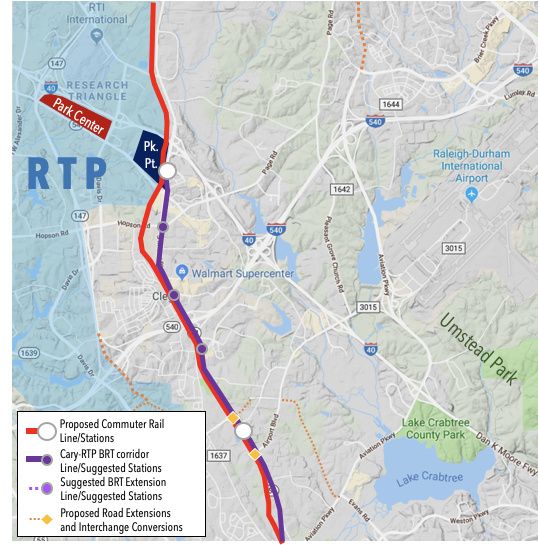
Branch out of the proposed BRT corridor from the McCrimmon Parkway area.
Possible extensions in the distant future: Park Center, Southpoint, and Chapel Hill?
EDIT: I also crunched some numbers (see below for my work), and it looks like construction alone could cost about this much (i.e. this doesn’t include right-of-way purchasing, planning studies etc.):
Suggestion A: $123 million
Suggestion B: $162~$164 million (depending on how you go around the Sheraton)
click me for more details
Don’t worry, I’m not pulling these wishy-washy solutions out of my ass; I tried thinking about the terrain, construction impacts etc. I couldn’t figure out how to make the McCrimmon divergence work (mainly because I couldn’t find any concrete plans about it), but I think you can get away with having reliable operations on a majority of these routes just by converting one lane per direction to be bus-exclusive.
The only exceptions (i.e. need to build new structures) would be for:
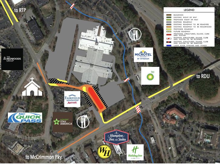
a flyover across Airport Blvd. onto Slater Rd. (suggestion B) or Perimeter Park Dr. (suggestion A)
weaving through the superblock wedged between I-40, Page Rd., and Miami Blvd. (suggestion B only)
Ballpark cost estimates
$81,000 ($60,000 in 2004 dollars) per pull-out area
$34 million per mile ($20 million per kilometer in 2016 dollars) for building new ground-level BRT path
(I used $20 million per mile for converting existing lanes to BRT-only, and $30 million for new construction)
$100 million per mile to build light rail (using ITDP’s conversion factors; DOLRT was $170M/mi)
$1.4 billion per mile to construct heavy rail (ditto to LRT)
add roughly $20 million per mile for aerial segments (i.e. you’re building a bridge for it)
Compare these numbers to:
$170 million per mile for Durham/Orange light rail (though this includes all the land development ideas GoTriangle packaged onto it)
$18 million per mile for Chapel Hill’s BRT (will mainly convert existing roads’ outer lanes into bus-only lanes)
$20 million per mile for the New Bern segment of Raleigh’s BRT (3-mile segment for $60M)
Segments in Common
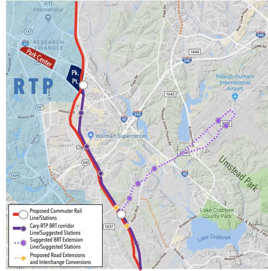
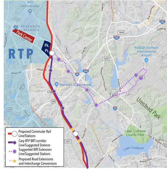
4.27mi (6.88km) - convert lanes on Airport Rd. in loop around RDU to/from Aerial Center Pky.
2 ground-level stops (former Morrisville Outlet Mall, two terminals of RDU)
Suggestion A only
0.43mi (0.69km) - convert lanes on Airport Rd. from Aerial Center Pky. to Sorrell Grove Church Rd.
0.37mi (0.60km) - build bypass bridge from Sorrell Grove Church Rd. to Paramount Pky.
0.72mi (1.14km) - convert lanes on Perimeter Park Dr. from Paramount Pkwy. to NC54
3 more ground-level stops (two in Perimeter Park, McCrimmon CRT station)
Suggestion B only
0.33mi (0.54km) - build bypass bridge from Aerial Center Pky. to Copley Pky.
1.23mi (1.98km) - convert lanes on Slater Rd. from Copley Pkwy. to current Regional Transit Center
0.24mi (0.38km) - build bus-only path from Creekstone Dr. to Old Page Rd.
0.27mi (0.44km) - build bus-only lanes on Central Park Dr. from Old Page Rd. to Miami Blvd.
4 more ground-level stops (Carrington Mill Blvd., Sheraton Imperial Hotel, Creekstone Dr., RTP Park Point)
I think this is the dedicated bus line is the solution. Separated it can make real time, my main complaint about buses - as stated before, if I am going to sit in traffic, I’d just as soon by in my own vehicle.
As to routes, I am not interested in going all the way past the airport to come back to it. If I lived in Durham, I’d feel the same way. Build both!
Might as well, I guess. You’d have to be able to justify the costs of doing that, though.
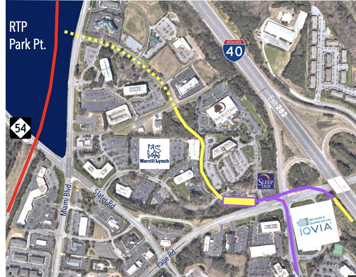
(Maybe you could, if you move the regional transit center near where the outlet mall used to be? Something like below, with the new/resurfaced roadway for BRT lanes)
Just an observation on the way into the office this morning. It looked like they were airknifing along the ROW of the east bound ramp to I-40 from Airport Blvd. I assume that geotechnical drilling will follow soon after they clear the boring locations of utilities. Maybe the upgrades to the I-40/Airport Blvd bridge/intersection are going to be happening sooner rather than later.