You’d probably have to sacrifice unit size and all surface lot driveways and parking. Outdoor amenities would likely have to be in courtyards over parking like they are in most all 5over1s downtown.
2 Likes
Also the site is dealing with large transmission power line easement inside the ROW along Saunders and South St. Duke isn’t going to pay to put the lines under ground. Plus a large sewer easement along the eastern property lines that can’t be shifted into NCDOT ROW without DOT approval and lots $$.
5 Likes
I attended the neighborhood meeting last night with some of my neighbors. This development will be a big improvement to the neighborhood. They have 3 designs which are dependent on DOT. The tallest building(s) will be either 7 stories or 12 stories at Dawson Street. The other buildings taper in height. The affordable housing piece of 170 units will be phase 1 building and also with a senior building and start this year while the rest of the project will be mostly market driven with a small portion affordable and take a number of years to complete. Total project of 1000 + units Stay tuned.
23 Likes
Thank you so much. I am sorry I missed this.
Did they give you any clarity around what “number of years” actually means? Thanks for the update.
1 Like
In Raleigh, “number of years” means “anywhere from a decade to actually never, haha sorry”
5 Likes
The development is slated to be completed by 2030. So a five year build out.
6 Likes
Not too shabby if they can keep to that schedule, but they usually drift.
2 Likes
Wow, look at those palm trees… will fit in well in our tropical climate ![]()
I know someone who loves to find the palm trees of Raleigh. @dtraleigh
1 Like
I wonder if we could sponsor a palm tree planting somewhere downtown, dedicate it to this community? ![]()
7 Likes
Coupla slides from yesterday’s Council Meeting on the HP phases moving ahead and the current thinking for the ‘grade-separated intersections’ in the vicinity…
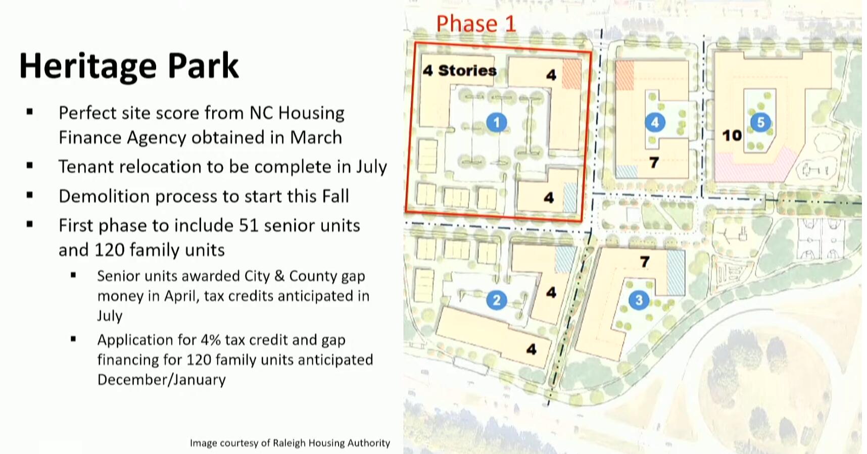
Blue numbers are the phase of construx, Black numbers story heights for re-Dev
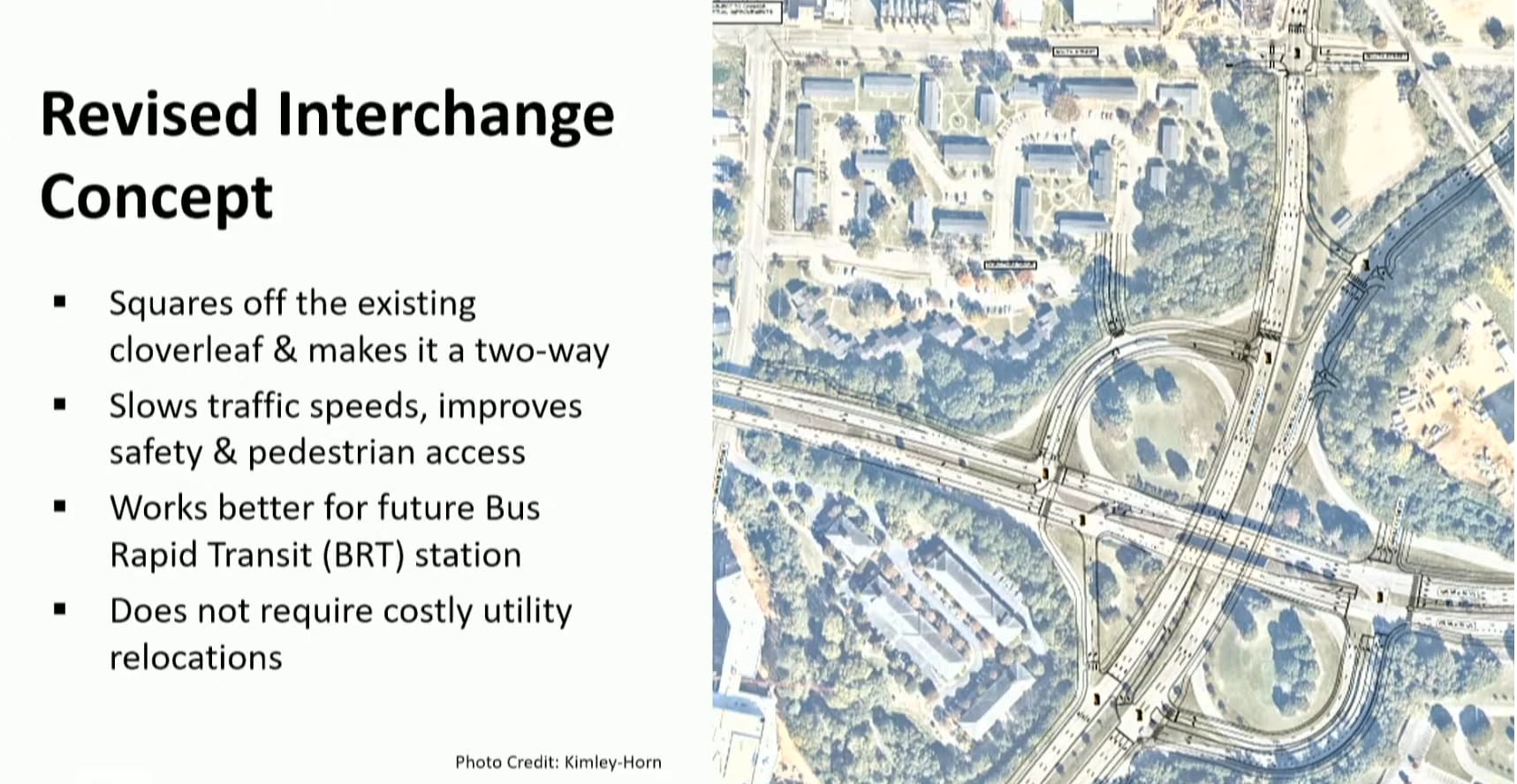
*Also, the discussions on the ‘slip lane’ south of Red Hat are progressing through design final, staff was ‘hopeful’ that could proceed EOY - which might put that on timeline – crosses fingers – with Red Hat wrapping construx for the 2027 show season in the new digs…
22 Likes
I like the 10 stories, but it’s a shame we didn’t get more density out of this development.
Did they say when the interchange redevelopment was happening? And does that new space from the clover become a part of the development or something else?
9 Likes
Agreed. Doesn’t seem aggressive enough for HP or the interchange…
Does not appear there would be any significant increase in developed HP land from this interchange revision and, realistically it won’t drastically alter the ‘feel’ of the interchange squaring out the cloverleafs nor will it really impact the ‘placemaking opportunity’ that exists there.
4 Likes
I was just about to post about HP. Did anyone know that all residents moved out? There are no cars parked and the southernmost buildings have been boarded up for a couple weeks. So this appears to be in flight already. I see the slides you just posted say July so that tracks.
Does anyone know where residents were temporarily moved and how that process played out? Hopefully they were relocated to the newly completed Toulon place, summit at sawyer, Milner commons, or somewhere comparable (and not just told to figure it out on their own). I haven’t seen an analysis but we have opened hundreds if not >1000 units, all subsidized, in ER over the past year. So there’s absolutely places for folks to go (yes the waitlist is long but it still makes sense for HP residents to have priority here because moving temporarily unlocks the new HP development with 10x the units) and it appears the HP timing was contingent on those other developments wrapping up. Just trying to confirm.
3 Likes
I like the additional traffic signals and the multiple areas with development potential throughout this new layout.
The diamond lot (farthest north) should honest be the first to be developed, then the remaining gateway lots, and then the spaces within the interchanges (dense housing and retail preferred). Overall, I’m not too worried about the reconfiguration but more so worried about bike/ped safety.
3 Likes
Disagree. If the ROW taken up by all the exit ramps can’t be abandoned as part of turning that interchange into a conventional intersection, then the exit ramps should just be left alone. The proposal a few posts up seems like a worst-case scenario where a ridiculous amount of land is still tied up by glorified exit ramps.
Imo, best case scenario is something like this, where the interchange is turned into a traditional intersection and some of the nearby streets are connected through. A park could probably go at the southeast corner especially since the Rocky Branch Trail is so close by.
4 Likes
I agree to disagree, your proposal looks like a nightmare for bike/ped and vehicle traffic with no connectivity (north to south) and large blocks.
Having the state/city’s proposed lots be developable along the reconfigured interchange will make bike/ped experience safer and more visually pleasing. Your proposed change would allow developers to build large block sized buildings creating a terrible bike/ped experience similar to that of the Seaport District of Boston.
Also, Dix Park supremacy ![]() at least in this area.
at least in this area.
2 Likes
Also this doesn’t make any sense when you account for the grade? Each side of Dawson/McDowell is straight uphill. McDowell to Kindley would be 30% grade!
**Edit: I agree that the property in the current exit ramps should be open for development but my understanding is that that is the City’s intent here.
3 Likes
Concept: stop wasting land for parking spots
3 Likes