Thanks for getting started on this! It’s definitely a good start.
I’m changing parts of the formatting (and simplifying/de-jargoning the language) and making it easier to skim through, since if this proposal is going directly to councilmembers, I personally have a hard time believing they’ll actually read every word.
The wye at the NCRR is a good idea, but then you have to tear up Hammond Road, which adds to the cost and scope.
As far as designing the alignment is concerned there are lots of things to consider. Curvature (vertical and horizontal), spirals (gradually easing into a curve to reduce lateral “jerk”), superelevation (basically, banking the tracks to allow higher speeds), turnout design, signaling plans, vertical and horizontal clearances, drainage, utilities (power, water, sewer, gas, etc), environmental impacts… and that’s before you get to the social aspects of it like property acquisition, public meetings, relocations, funding, negotiating withthe railroads, the city, and the state…it’s horrendously complicated stuff, and there are probably twice as many things that I’ve forgotten to list because I am not a professional who does this for a living. I do my best to make my diagrams sort of realistic but (for example) in my alignments I did above in Google Maps I didn’t even take curve spirals into account, and that’s like basic, basic stuff. I have busted out autocad and fumbled my way through a basic alignment for this, but there are lots of things I don’t know how to or just can’t (eg, most utilities don’t just publish their diagrams on the web as far as I have been able to find.)
The best we can do is hope to get the attention of somebody who does know how to do some of those things and hope they don’t turn up some fatal flaw with the idea. But getting people to take you seriously when you don’t have “, PE” after your name is difficult…
One interesting fact in this exercise, is the new current Malik/Kane ownership of the land adjacent to the NS line above Carolina Pines. Did somebody in that partnership recognize the value of that seemingly worthless wetland?
If so, then they probably got it at a pretty good price before the word got out. Smart. Very smart.
The Hammond wye could be a later phasing of the project. But, that it’s already somewhat prepared for the connection, and undeveloped at that makes the do-over less heinous.
Spinning this for the addition of a South Raleigh station is a key take-away point.
@keita, I’m curious what you mean by this statement:
“Bringing the ROW into city ownership should help to further avoid the appearance that Dix Park separates southeastern and southwestern Raleigh neighborhoods”
I’ve not heard this… is it a prevailing feeling about the Dix property?
Can’t speak for @keita, but there was some talk about somehow enhancing the connection between Chavis to Dix at an earlier part of the development process than the connection from Dix to Pullen.
It’s an implied sentiment that I’ve heard from some of my friends who are pretty active in left-leaning political things -so I wanted to nip it in the bud before it could become a problem.
If I had to come up with a way to add in some borderline-true misinformation, blow this idea up, and turn it into political poison for councilmembers, I would frame (to give @orulz and @dbearhugnc’s ideas a name, based on what we first called Downtown South on this site) this Penmark shunt idea as:
a racially-insensitive act of social injustice akin to modern-day redlining (which will piss off local and/or college-age activists), and;
an attempt to increase property taxes in low-income areas (y’all can guess who this would annoy)
I don’t think the Penmark shunt has to have those negative points, and wanted to make that clear.
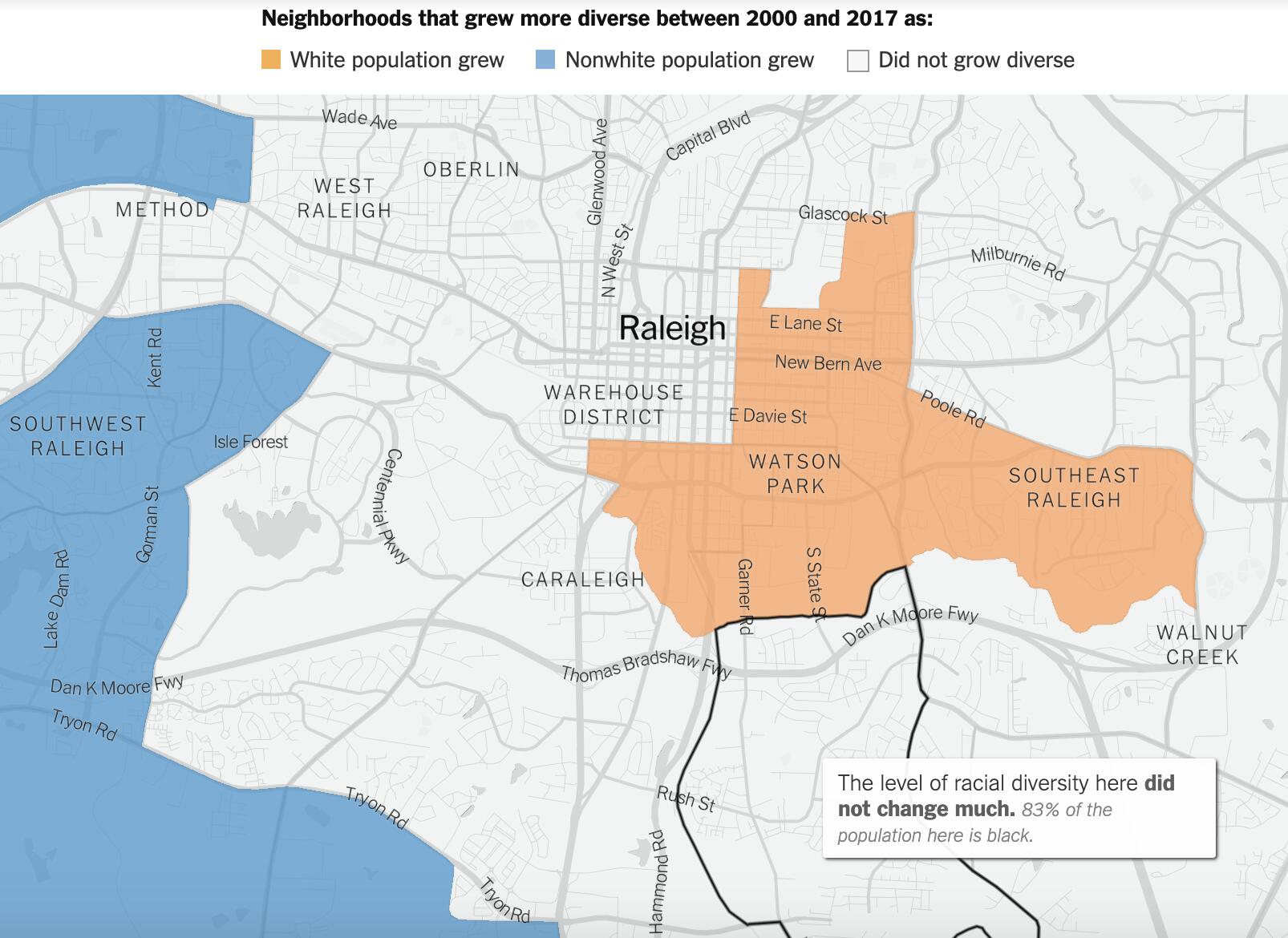
From how I understand my very-left-leaning friends, Southeast Raleigh’s being seen as a part of the city that’s getting more and more “left behind” or “left defenseless” in the explosion of growth and attention that’s happening downtown/in North Hills/around NCSU. Remember: this is the part of Raleigh that’s in city limits, but was affected by redlining, is somehow still a food desert, and barely has any sidewalks/crosswalks among other issues. (And we know that even something more routine and hype-worthy like the Chavis Park renovation almost seems to be subject to different laws of physics east of downtown…)
Combine this demographic info on who lives around our Penmark shunt ideas…
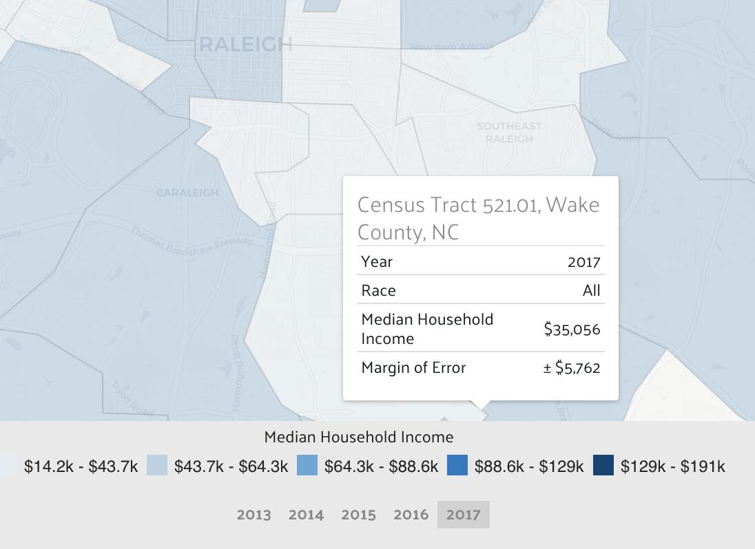
…and the average income of the people who live there (if this is your livelihood that informs your short-term needs, would you really care about some train track realignments even if it might screw you over years in the future?)…
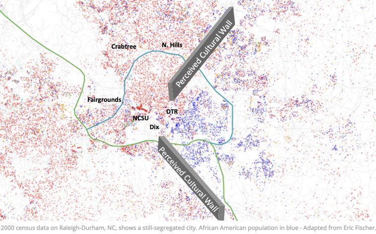
Moving the barriers I drew above is what I’m worried this proposal could sound like. A proposal like that would mean two things:
additional opportunities for cheap, market-rate housing (what we call “development opportunities”)
rising costs-of-living, leading to more people facing evictions/in-county migration to neighborhoods with fewer job/school opportunities (what some people consider “gentrification”)
I’m wondering if it would be better to frame this proposal as a way to break down those barriers? This would mean:
“development opportunities” (by definition)
the removal/moving of a physical barrier between neighborhoods could help create a cultural connection that diffuses out the “good parts” of new developments
I feel like this problem of perception could be a (low-chance but) high-impact risk for this proposal, similarly to the excuses Duke hid behind to kill Durham’s light rail project. Isn’t it worth it for us to think about the economic justice of this project from the very beginning?
@dbearhug the Kane/Malik property is definitely wet but it is also buildable. I do not think it is listed as a flood zone or wetland on flood maps. I have absolutely no facts or evidence to back this up, but I suspect this is where they dug up some of the dirt to make the I-40 embankment. Before developing the site, it will have to be extensivelynre-graded which will probably involve digging up a lot of dirt from the back of the property(near the RR) and pushing it closer to South Saunders where the elevation is 60’ lower.
Interesting bit on the property from doing a deed search. It hasn’t changed hands since 1961 when it was assembled by NC Equipment Company (the place that had the bulldozer sign on Hillsborough). Before that, the property header mentions ‘ADAMS LD ORPHANAGE PROP’. And, of that, there is little mention in the online record of any orphanages beyond the two well-known facilities operated elsewhere by the Methodists and Catholics. If the property in question had been part of a ‘Colored Children’s Asylum’ (the prevalent terminology from 19th Century North Carolina) I can’t trace it.
So, you’re right, it was likely a site for fill dirt when I-40 (or whatever it was called back then) was being built. And,nobody else in the past 60 years has felt that the property had any value until now. Hmmm.
@Patrick Another, but later point, is going to be how to re-engineer the ROW into a greenway. There will be the easy bits at the south end as far as trailheads. The I-40 bridge and Western Boulevard viaduct will also need guard-railing, too.
And, there will need to be some thought as to transitioning the north end up to street level.
But, a key way to spin this is the cost savings of recycling the bridge over I-40 compared to the costs of a new crossing or having to re-engineer Lake Wheeler Road. The $11M American Tobacco Trail bridge over I-40 at The Streets at Southpoint immediately comes to mind.
@ all ya’ll: I can’t tell you how much I’m digging the enthusiasm and thought being put into this idea.
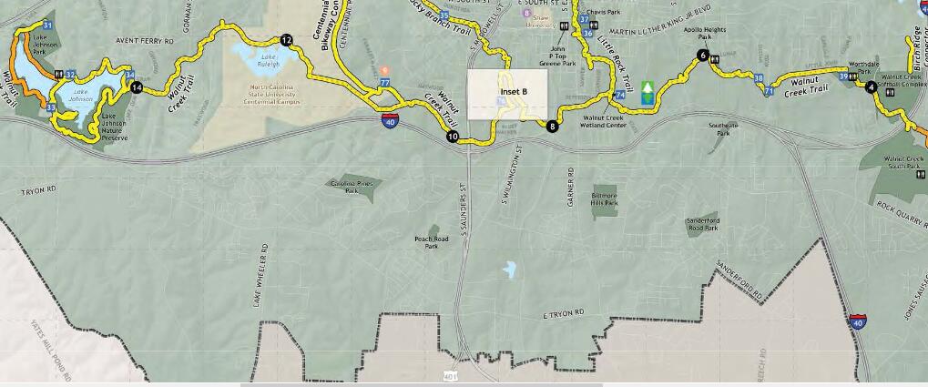
Getting non-auto dependent greenway access for people south of the belt line continues to occupy a big piece of my mind and motivate much of my community involvement efforts. It’s clear from this image taken from our greenway system map that greenway access on the south side of town is not equitable:
If you’re ITB, great! Look at all those greenway connections! If not, you’re SOL.
But the thing we have to keep in mind is that none of this matters if NS is not interested in selling or donating their property. I’m sure city staff and council members are aware of how converting this rail road to a greenway would be hugely popular with citizens, but what’s in it for NS?
Why should they care? Why do they want to limit their options for freight routes in this area? Do rail roads even pay property taxes on these right of ways? I honestly don’t know, just trying to think of financial drivers that might motivate them to sell.
Again, I love this idea - I think of it as the gold standard for a greenway connection across I-40 because of how it would reuse infrastructure; is almost completely separated from auto traffic; and connects directly with neighborhoods, existing greenways, and destinations - but getting the city to buy in won’t be the hard part. NS has to be convinced that selling is in their best interest. And for now, they’re still using the tracks. I can hear the trains from my house.
This is why we mentioned efficiency improvements for NS:
…though to prove this point, we would need NS’s help/data to see:
How many trains are slowed down due to complicated maneuvers across the Boylan Wye? How many dollars of lost revenue does this translate to? (this establishes the need for this connection on NS’s side)
What customer opportunities is NS losing because of Boylan Wye being a logistical bottleneck? (this is the most immediate opportunity for NS being down for a Penmark shunt)
What are the time windows where engineers and surveyors can study/build an alternative rail connection in a way that least disrupts (if at all) existing train traffic? (this is a genuine attempt to counter people who think this will just “get in the way of our business”)
I get why you’re concerned, but I think that is exactly why we need to have this conversation. There’s reason to think this will be good for NS as well, but they will need a reason to take this idea seriously; official consideration by the city council will be a good first step for that.
Any freight movement from the VF Line has to come up through the diamonds to Glenwood Yard dwelling for the night. This allows a reposition of the motive power from front to the back since there’s no turnaround (freight cars don’t care what direction they travel).
Then it has to come out of Glenwood Yard accessing the Boylan Wye at Southern Junction. Depending on dispatch, the movement is forwarded on to either NS East Durham or NS Selma. Trains aren’t likely broken apart there, but further out in a bigger classification yard like NS Spencer in Linwood.
The same goes for movements from either NS East Durham or NS Selma. All has to be shunted up to Glenwood Yard. Wait the night. Reposition the motive power. Then, head across the diamonds to the VF Line.
Kinda inefficient, yes?
But, it’s a legacy of the original NSRy when it shoehorned itself into the geography of the region back in the 1910’s. And, that system has largely been spun off over the years after the SOU merger, then the creation of NS.
Now, with the Cutoff, VF Line traffic can head directly to NS Selma or NS East Durham, effectively bypassing NS Glenwood Yard.
Would this effectively kill off NS Glenwood. Sure. But, it’s a valuable asset waiting for re-purposing/sharing. With the APX-WKF service, the FAY-RGH service, and even the VAR-RGH service there’s going to be a need for a coach yard to store, re-supply, clean, and re-fuel. There’s a lot of now-unused yard capacity just sitting around.
NS Glenwood could effectively become our PRR/MTA Sunnyside Yard (for those who know don’t know, Sunnyside is where Amtrak and others agencies layover for servicing when having gone through NYP/New York Penn Station.). The yard could be purchased outright, or more likely just be leased from NS.
Remembering that we aren’t just talking about the current levels of traffic. Add in the additional 8-2-8-2 GAR-DUR movements, then APX-WKF, and then FAY-RGH things start getting really tricky.
So, if all of that coming/going through CP Boylan has to slow down to 15 mph to traverse the diamonds, the delays can add up pretty quickly for the continuation of 2 freights a day servicing customers on the VF Line.
Not being on the inside of the transit planning agencies, I can’t say for sure, but I suspect that The Boylan Diamond is likely a huge impediment in the way of both commuter rail and High-Speed Rail on the S line and the H line. It is entirely possible that congestion at this diamond could be the main reason that better Midday service for commuter rail is not considered realistic or possible. When compared with the cost. of building a conventional grade separation in a built-up area like the Boylan Wye, it is almost certain that a bypass such as the one that we are proposing here would be much more constructible and feasible.
This is basically the same situation that causes NCDOT to usually favor building a bypass on a new location instead of upgrading an existing highway to a freeway in places like Shelby, Asheboro, Goldsboro, and dozens of other places.
If NS wanted to build the Cutoff with their own funds and abandon the NS Line through Dix, they could do it with little or no municipal input. There would have to be a petition to the Surface Transportation Board who would look only at the needs of the freight customers to be sure their current services were being met. All of the modeling, movements, etc would happen there. End of discussion.
Now, if we start looking at getting federal grant money for the Cutoff as part of the abandonment/bypass diversion, then a NEPA review would have to be brought into play. All of the environmental, historical, and social justice impacts would have to be publicly weighed into the decision. So, @keita’s comments would be brought in as well as others we haven’t anticipated.
I believe that for private entities to exercise their right of eminent domain (railroads have it, as well as pipeline companies and utilities such as telecom and electric companies, among others) they do have to conduct an alternatives analysis and environmental impact study. I am not entirely sure though.
It would be difficult or impossible to acquire the land to build this bypass without ED or the threat of it. A single reticent property owner could throw a spanner in the works.
NEPA is a much less dicey process than FTA New Starts, and there is generally a way to successfully navigate it once the purpose and need is established.
My bad. You’re right. The STB has an Office of Environmental Analysis. I was operating under some old assumptions. I’d add some links, but their website is acting a little wonky at the moment.