Rail Line to Fuquay-Varina

Yup. If NS were to abandon rail traffic from Varina to Southern Junction, they would still own the ROW. Then, it would be a bidding/juggling game as to whether the City of Raleigh would get first crack over GoTriangle or the NCDOT.

The NCDOT would be interested in corridor preservation for future freight. GoTriangle would want preservation for future passenger use. The City of Raleigh would likely want it for greenway use.

What’s also potentially huge is that if NS were to abandon the original NSRy tracks from Southern Junction to the diamonds at CP Boylan, it opens up a lot of real estate along the western leg of the Boylan Wye.

And, the diamonds at CP Boylan could finally be removed. Those are points which slow down any kind of train movement.

6 Likes

NCDOT, North Carolina Railroad (for the route from the downtown wye to I-40), possibly CSX even, since they control the RR signals between Raleigh and Cary.

Class 1 railroads lately are on a kick of selling off or leasing branch lines to short line operators. Anything that is not strategic for their national network, they divest. They have already done this with the line from Raleigh to Wilson. The lines from Asheville to Saluda and Asheville to Dillsboro have met a similar fate. It is reasonable to think that they might consider a similar measure from Raleigh to Fuquay as that is not an especially busy line for freight traffic. They prefer to focus on things like large intermodal facilities and industrial facilities that receive or ship hundreds of carloads per week, not places that take a couple cars a week.

The class 1’s still get to carry the cars to the branch lines, but they leave the tedious, labor intensive work of switching them to all the small customers along the branch to the shortlines, who tend to have cost structures more conducive to that.

4 Likes

I’m looking at the alt routes. I’m sure a formal analysis would need to be done, but it looks like the green route would have the least impact on the community.

@Brian It seems to me this is broader than just Dix. Would Planning or Transportation be appropriate parties to make inquires?

Scroll back to post #97 of this thread, I posted some cool maps.

1 Like

Again, any of the double dogleg connections that have been suggested between the NS and H lines imply that freight traffic on the VF-line would still need to connect to the larger NS world - i.e. NS Glenwood Yard, NS East Durham Yard, NS Selma Yard, NS Linville Yard.

The biggest freight customer on the VF-line is Kelly Springfield. And, that is much closer to the CSX A-line. So, if the VF-line is spun off to the same short line company which just purchased CLNA, (or even more likely Aberdeen & Rockfish), any of those expensive color connections done by @orulz or myself would not be needed.

Now, after this freight traffic spinoff, the only time that a NS/H connection through South Raleigh would be needed was for any future commuter train coming up from Fuquay-Varina needing access to the unbuilt commuter platform on the south leg at RUS/RGH. Then, it would access the Boylan Wye from the east going through CP Hunt.

Again, it’s the cheapest (and certainly the least disruptive) solution to the question that I’ve been able to come up with.

1 Like

That looks pretty similar to the green line from my map above. I think that one is a bit more impactful, though, and here are the impacts that IMO put it in a different category from the yellow line.

  1. It threads the needle between a cemetery, a funeral home, and a church, risking impacts to one or more of them. These are the sorts of impacts that tend to get red-flagged during environmental studies.
  2. It requires rebuilding the S. Saunders/S. Wilmington interchange which is a very busy junction. Phasing these sorts of things are costly. Maybe they could nix the interchange and just bring it to an at-grade intersection, though, like they did with Hillsborough/Western near Jones Franklin.
  3. It impacts a large number of X-plexes (4-plexes?) along Peach Road which are quite affordable.
  4. I think it would potentially cut through a public park near Peach Road Community Center, near where it would cross a future connection of Ileagnes Rd.

But there are benefits:

  1. It is the shortest connection
  2. It bypasses another grade crossing (Carolina Pines Ave)
  3. It abandons a longer stretch of the NS line.
  4. Doesn’t touch Kane’s property

Because of benefit #4, this is probably the only realistic alternative if Kane declines to play ball, and nobody has the appetite to force him. Forcing might be easier than you’d think, though, because there is leverage: the rezoning process (carrot- it’s only zoned IX-3 now) and threat of eminent domain (stick: without rezoning, they could condemn and force a sale at a cost only assuming existing zoning).

3 Likes

Yeah, you’re right. I was looking at your map from my phone.

I think it is possible that losing the connection on the north end could drop the value of the line more than the cost of building the connection, but that depends a great deal on the cost of building it, particularly when it comes to using the line for transit. The area along US401 might not be very dense today, but I think it’s inevitable that this won’t hold true for very long. With everywhere between Raleigh and both Jordan and Falls Lake essentially filled in, south and east are the next new frontiers, and with 540 going in as we speak, and with the tendency for developments today to be denser than they were in the 90s when North Raleigh mostly finished its build out, I think a rail line to Fuquay will be needed in my lifetime.

4 Likes

I’ll be asking for suggestions on who else on city staff I should speak with.

I also think reaching out to the Downtown South folks needs to happen as @orulz has suggested. I would guess they’re thinking about how to connect their properties North and south of I-40.

Saw in another thread that part of the city council retreat agenda included touring the DS site.

1 Like

Valid points. But, in trying to connect the dots, is there value to NS for having access to a straight shot from Wilson to Fuquay-Varina or Fayetteville using the old NSRy ROW? Probably not. That’s a piece of legacy trackage from the predecessor that they ingested decades ago. Their concern is probably only going to be mainline movement between their yards. (Linville, Pomona, East Durham, Glenwood, and Selma)

They likely have more of a locked in commitment to the NCRR and possible bulk shipping increases which might be coming up from future upgrades happening at the North Carolina Port at Morehead.

We’ll call it the Kane Cutoff. His name will be permanently ensconced in the NS list of names for various CP’s, Yards, and Interlockings.

And, let’s go large. The Kane Cutoff would also give more gravity to a South Raleigh/Malik Stadium depot getting feeder traffic from Fuquay-Varina as well as points east from Garner, Selma, and Fayetteville!! (Cutoff definition)

Suddenly envisioning the special rail service by the MTA and NJT to the New Jersey Meadowlands.

http://web.mta.info/mta/sports/meadowlands.html

https://www.njtransit.com/sf/sf_servlet.srv?hdnPageAction=MeadowlandsTo

And, @orulz, to future-proof this cutoff, we’d probably need to make the connection at the H-Line in South Raleigh as a wye. Then, you’ve created a true belt line which means that there could be movement from Varina to Garner/Selma bypassing RGH/RUS.

10 Likes

@dbearhugnc you mention Glenwood Yard but wasn’t there some news that NS has ceased operations there some time within the last year?

NS thought that with the yard expansion at Selma, everything would be handled between there and East Durham. But, they’ve reactivated at least one trick/shift at Glenwood for movements specifically in/out of the NS and VF Lines.

1 Like

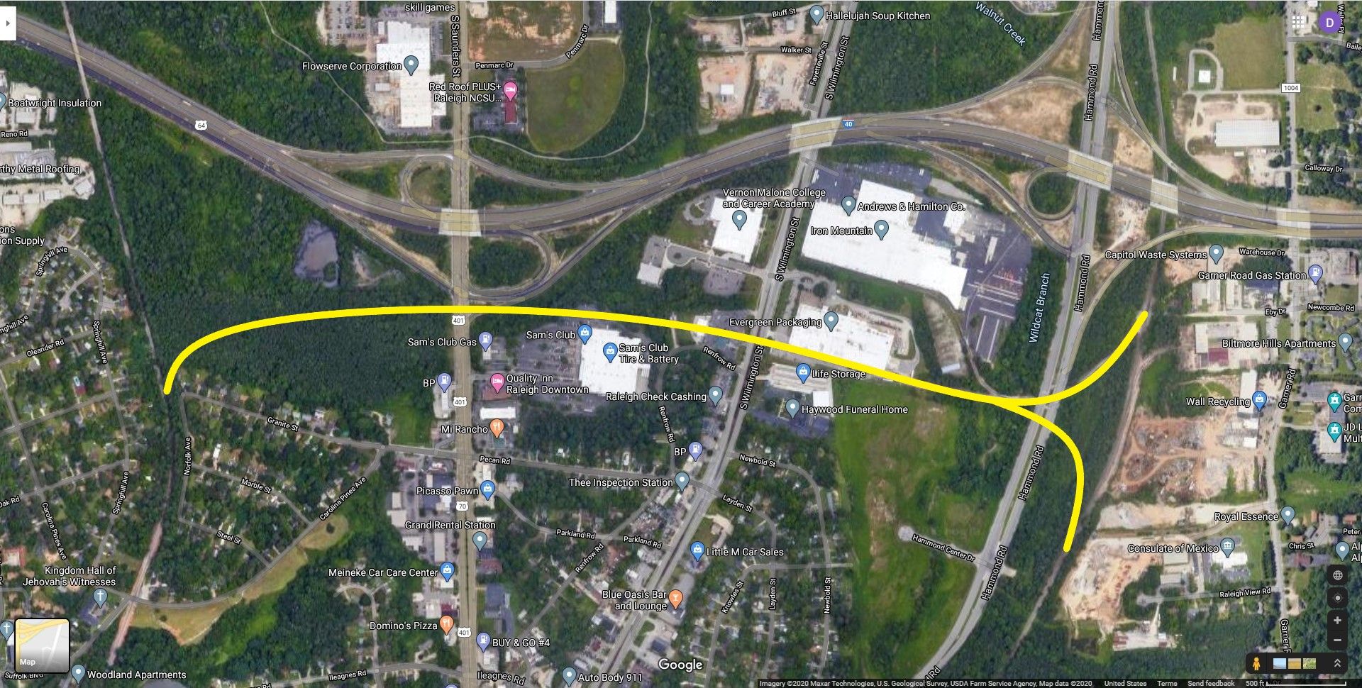
My vote’s on the @orulz Yellow option (which is only a little over 1 mile in length between the two points).

First, diverge to the East from the NS Line through undeveloped land (now owned by Malik/Kane) on the south side of I-40 proceeding over to South Saunders.

Second, go on viaduct over South Saunders, skirting around the Sam’s Club property. Take out HC Auto & Body as well as RDU Gold Buyer while missing/relocating a cell tower off of Renfrow.

Third, continue on viaduct over South Wilmington, coming down to grade adjacent to Evergreen Packaging’s spur.

Fourth, pass under the existing Hammond Road bridge/overpass. Then, meet the H-Line with a wye.

This possibly doesn’t touch any private homes (although it gets kinda close to the end of Granite Street and Norfolk Ave - so there still may be some sacrifice). Will take out two businesses and a cell tower while requiring a NEPA wetlands review. It leaves the NS ROW intact for greenway access from Carolina Pines to Boylan Heights, going over I-40 and Western Boulevard using intact bridges.

The ‘Yellow’ Belt Line/Kane Cutoff takes freight traffic out of Dix Park while still giving NS’s freight customers to the south a connection to any of the freight yards already mentioned. If/when the NS and VF lines becoming repurposed or reconnected to the outside world at other places, then the ROW from Carolina Pines to Varina is still available for passenger traffic with little reconfiguration required.

Would probably put the South Raleigh/Malik Stadium station at the old Cargill site while envisioning that the whole industrial zone on South Blount to be completely revised as an urban zone. The distance between Cargill and the proposed stadium is about a mile - so walk, bike, scooter, is do-able given that there will likely be a direct connection programmed in when the time comes.

The project cost for freight rail is $2.5M per mile exclusive of land acquisition, environmental review, bridges, tunnels, and culverts. Some other single rail transit projects have come in at $20M per mile, and one streetcar project hit $50m per mile. But, we’re looking at just a one mile connection.

[This is so perfect, and I’m amazed that somebody hasn’t thought about it already.]

5 Likes

I wrote up a proposal to take to the City. It’s a first draft. You can see it here:

Proposal: COR to purchase Norfolk Southern NS-Line ROW - Google Docs

I chose not to get into all the alternatives that have been suggested in this blog. I imagine establishing alternatives requires a very methodical process. With that said, I welcome edit and recommendations that enhances the proposal. I do think this document should remain focused on the benefits and high level path to achievement. I envision the primary audience being City staff and Council.

@Brian I’m hoping you bring this (or some version of it) with you when you meet with City Staff.

6 Likes

Nailed it. Looks like a really good start. No changes suggested beyond one subtlety. I think the I-440 designation only goes around the upper portion of the Beltline. Through downtown, it’s just I-40.

1 Like

ah… good catch. Thank you!

2 Likes

Anyone in the blog can edit this doc btw… I appreciate any recommendations.

1 Like