Well. Based on your assumptions of how bad things currently are and that you feel they are not even remotely being looked after currently, then I would say yes that would be kicking the can down the road. But in my opinion, that is not happening. Raleigh is not particularly expanding much area wise nowadays and almost all growth is going on within the current city limits. Density is happening all around us. Growth is happening all around us. Most people commenting in here seemingly want to go from A to Z in one jump. Sometimes transitions seem slow but yet in reality Raleigh has been transitioning for growth and density and it is here around us now.
2 Likes
Cost of living is a far bigger factor than taxes. The middle class is simply priced out of Manhatten, and similar areas. It’s a fundamental unsoundness within capitalism, using real estate as the primary form of investment for most people.
NC historically has invested more in education and utilities than neighboring southern states. Without the skilled labor pool nobody would be coming here.
3 Likes
Deep breath…Okay, while I say that there’s actions that we can take today to prepare for our aging infrastructure, I have never made statements that you are extrapolating here. Where in fact did I ever say that our infrastructure is “not even remotely being looked after currently”? We may have differing opinions, but please don’t take the liberty to put words in my mouth that I didn’t say. I will do my best to give you the same courtesy. (I was looking for a handshake emoji, but one doesn’t seem to exist to use here.)
2 Likes
Well I was being facetious and somewhat flippant and sarcastic all at once. I guess we just see things differently. I see mostly good. I guess I find it difficult to understand why others find fault in almost everything we talk about in this blog. Sometimes reading in here you would think Raleigh is the worst city ever. I don’t live in Raleigh but I find myself defending it…
1 Like
If you scroll all the way back to my first post of the thread, you’ll see some of my thoughts/answers to your question. In short, a MSA is very public statistical face of a city.
1 Like
If they would upzone Long Island and the Lower Hudson Valley, plus in some of the higher demand neighborhoods of NYC, they could stem a lot of that population loss. But it’s no wonder people are leaving, since NYC, and especially its inner suburbs, are operating as though they are “full”. Drives up the cost of living tremendously. Population in places like Westchester and Nassau isn’t stagnant because of some narrative like “Millennials don’t want to live in the same boring suburban areas as their parents” or “lib’ruls taxin’ em all outta thar!”… It’s because building new units there is damn near impossible.
6 Likes
A lot of reason that large Northern cities have high taxes and infrastructure problems is they got large many years ago and their infrastructure is old and past it’s life expectancy. Sure you know it’s many times more expensive to replace than building new in undeveloped areas. lol Chinese friend of mine was appalled at the NYNY subway system. I had to explain to her that lot of what we were seeing is around 100 years old, not the shinny new 10yo subways of Beijing.
3 Likes
Thanks for this. Let me expand on what you say and talk about how it relates to us.
So, this is the conundrum for aging Sunbelt cities like Raleigh that boomed in the suburban age. Infrastructure that was put in place in the 60s and 70s requires more maintenance and will be scheduled for replacement as it ages out of usefulness. Because of the low density development, the amount of tax revenue generated per inch/foot/yard/mile of infrastructure is low in these suburban areas. The short term answer to these problems is to make our taxable land more productive through densifying and creating more revenues per square mile. It’s unrealistic to expect wholesale removal of our suburban single family neighborhoods, so what’s the next best thing to do? Well, as some of us suggest, the answer to these issues lies in finding nodes in the city that can support more taxable real estate to generate revenues needed to address the costs of maintenance and replacement. Downtown, especially, is well positioned to carry more than its fare share of the financial burden because it can both generate more taxable real estate per acre, while commanding higher prices per ft2 (square footage that is all taxable real estate).
Said another way, my 1100 ft2 condo has a taxable value similar to a suburban single family home that’s twice its size on a quarter acre, all while sharing its developed 1 acre plot of land downtown with 82 other residents paying similar property taxes to the city.
Let me be clear, I don’t resent paying (arguably) more than my fair share of property tax because I perceive a value to my life of being in the city. I made this choice. Many others also choose to live downtown for lifestyle reasons and are also willing to make that investment and carry the financial burden that comes with it. Everyone in the city benefits when these dense areas of the city grows and become more dense because it drives more revenues. If the core of the city didn’t grow, and if the city didn’t identify/encourage other nodes of density throughout its nearly 150 square miles, then it would really be in a financial pickle as its infrastructure neared the end of its useful life.
The good news is the the city is getting more densely populated as its population and taxable development grows faster than its land footprint. This is a reversal of the pattern that was seen over prior decades when the ppl/m2 decreased and we spread out. While I don’t know what the perfect density metric is, I am going to guess that we haven’t reached it yet. I think that the city is still statistically less dense than it was in 1950 before sprawl took over.
In my mind, whether right or wrong, I think that we’d be better positioned if we could get our municipal density over 4000ppl/m2.
4 Likes
KenAA, I hope that you don’t mind, but I am re-posting your AWESOME information to this thread…
Leo, should I have asked for you to do this?
It’s interesting that Raleigh’s density is the highest of any city in the region, 3.1 now, heading to 3.4 just a few years. In fact the largest cities in Wake County are more dense than Durham or Chapel Hill. Intuitively, I’d have figured the college towns would be more dense.
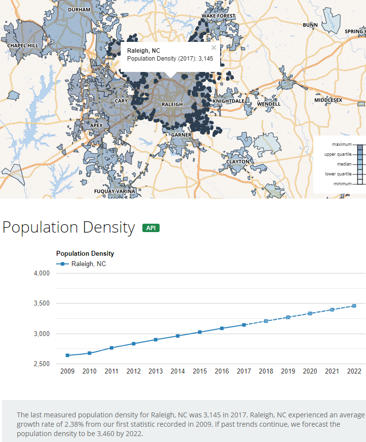
3.1 Raleigh
2.9 Cary
2.9 Apex
2.8 Chapel Hill
2.4 Durham
You geek out on the map by clicking various cities.
https://www.opendatanetwork.com/entity/1600000US3755000/Raleigh_NC/geographic.population.density?year=2017
i.e.
2.7 Charlotte
2.2 Greensboro
2.0 Asheville
7 Likes
Carrboro is actually the highest I believe at 3265.
2 Likes
Carrboro has long been the most densely populated municipality in NC, but it’s hardly an apples to apples comparison to the larger, more complex cities. If you believe the projections from that site, Raleigh’s density will put distance on Durham, Greensboro, and Winston-Salem going forward. Charlotte will lag Raleigh but be on a similar trajectory to it (though several years behind), and Cary will close the gap on density with Raleigh, while Apex will actually pass both Cary and Raleigh. Carrboro’s density will have a parallel trajectory that prevents Raleigh from passing it in density through 2022, but Apex will be within a hair’s breath.
The shocker to many might be that Morrisville is going to pass all Triangle municipalities by 2021. I guess that all that small lot SFH stuff makes a huge density metric impact?
A future look at Wake County could be really interesting with larger lot SFHs being closer in to DT Raleigh with high density SFHs on the outer edge and high density nodes around the county, led by DT Raleigh. The time will soon come that those looking for larger lots will have to look in older parts of the city rather than in outer burbs. How ironic.
4 Likes
You have given me a new obsession. Thanks!
But, probably most valuable is that this site provides a nice overview map of the municipalities in the Triangle and shows just how connected it all is. The only thing missing from the map is a “municipal” designation for RTP proper, though you can make it out on the map because it’s the empty hole.
3 Likes
@John, do you have any background why Raleigh and Durham MSA’s were split in 2003? And, do you know if local governments have any say into these decisions?
I don’t think that it would be a surprise to anyone to learn that Durham wanted its own MSA, but I am not sure if that “want” was accompanied by any particular action that shaped the outcome in 2003. That’s a fancy way of saying that I don’t know. There was a pretty pro-Durham narrative, pre-split, that seemed to suggest that the Triangle’s (mostly known as “Raleigh’s”) strong data was mostly because of Durham’s side of the metro, and that Durham would shine on its own if split. Post split, I don’t think Raleigh’s data has been particularly damaged other than the Triangle’s true size being diminished. On the other hand, the slower growth in the Durham-Chapel Hill MSA has taken them completely off the table when large (more than 1M) metros are being discussed. They lost their shared seat at the table.
I still think that the Triangle will be reunited under one MSA sometime in the future, but I don’t dare guess when that might happen.
6 Likes
The reason that I remember is that the percentage of commuters from Durham County into Wake County was not high enough to justify the combined metro area. The percentage of Wake commuters into Durham County was fine. Apparently, the percentages were supposed to meet some kind of threshold. Of course at the time, most of RTP and its workers was in Durham County.
Will bet that Wake commuters to Durham, 80% or more got no farther than RTP.
This is where Durham County gets its Wake commuters. I’d love to know the breakdown of workers’ home counties on the Durham side of RTP. It wouldn’t surprise me at all if the largest share of them live in Wake. Regardless, with Wake growing ever larger, the % of people that cross into Durham for work most likely decreases, even as their numbers may actually increase.
2 Likes
I was thinking this evening about how I could demonstrate how remarkable Raleigh’s growth is vis-a-vis its sister cities in the Southeast: those MSAs between 1-2 million people. So, I took to the latest data (July 2017) and enumerated it below. The comparison among these 10 MSAs will show that, while Raleigh has the smallest footprint by far, it also has the fastest growth rate. At the MSA level, it’s also the most densely populated. It’s in this comparison that it’s harder to swallow just how kneecapped Raleigh and the Triangle are statistically compared to other metros in the Southeast. Below are the 10 MSAs in descending order of physical size, their populations and their average growth rates per year this decade through 2017.
Nashville: 14,735 km2 - 1,878,181, +1.84% per year
Oklahoma City: 14,275 km2 - 1,383,737, +1.38% per year
Memphis: 11,857 km2 - 1,339,948, +0.25% per year
Birmingham: 11,626 km2 - 1,085,749, +0.32% per year
Richmond: 11,303 km2 - 1,270,746, +0.95% per year
Virginia Beach: 9,168 km2 - 1,761,753, +0.38% per year
Louisville: 8,382 km2 - 1,261,522, +0.66% per year
New Orleans: 8,294 km2 - 1,275,762, +0.97% per year
Jacksonville: 8,293 km2 - 1,504,980, +1.56% per year
Raleigh: 5,486 km2 - 1,335,079, +2.32% per year
Now, if we combined Raleigh’s and Durham’s MSAs, the Triangle would be the most populated among the 9 others, and it would still be physically smaller than Nashville, OKC, Memphis, and Birmingham. The two MSAs combined have 1,962,064 in 11,415 km2.
Without Durham, and despite being much smaller than the other 9 MSAs, Raleigh was the 5th most populated among this group in 2017, and given Memphis’ weak growth rate, is assuredly 4th as of the yet to be released 2018 data.
15 Likes
For reference: where is this data coming from? What is Durham’s growth rate, and what does the growth rate look like when Durham and Raleigh are combined?
For reference: where is this data coming from? What is Durham’s growth rate, and what does the growth rate look like when Durham and Raleigh are combined?
The data comes from here: Metropolitan Areas (USA): Metropolitan and Micropolitan Statistical Areas - Population Statistics, Charts and Map
Durham’s MSA growth rate has averaged 1.47% per year since 2010, and that’s still a faster growth rate than all but Raleigh, Nashville and Jacksonville among the 10 that I listed.
I played with excel to see if I could figure out how to blend Durham’s slower rate on a smaller population with Raleigh’s faster rate on a larger population, and came up with 2.115% per year combined.
The Triangle’s CSA is just over 2M now (with the adjustment of counties down in the latest Census designations) and has had an average growth rate of 1.98% per year since 2010.
Another interesting thing that I calculated was that Raleigh’s MSA alone will likely reach the current combined population of both Raleigh’s and Durham’s in about 17 years. Looking backward, it took Raleigh’s MSA ~15 years to reach the combined 2000 population of both MSAs. This suggests that Durham’s MSA has seen an acceleration in growth this Century, even as it continues to lag Raleigh’s growth rate.
Special note: the combined Raleigh + Durham MSA numbers are a different thing than the CSA, because the CSA is even larger.
https://www.citypopulation.de/php/usa-combmetro.php
4 Likes