Yeah, yeah, yeah, I know that this title is click-bait but hear me out.
The prevailing narrative, even among DT Raleigh boosters, is that Raleigh’s core is just too small. Well, I am here to say that it’s not necessarily true. I love playing with the mapfrappe website & I decided to compare the size of DT Miami to DT Raleigh. Given that I am very familiar with Miami, I outlined (IMO) what constitutes the functional urban core of Miami. That includes DT proper + the north side of Brickell to its south, and Omni to the north.
As it turns out, all of that area is pretty comparable to DT Raleigh proper as defined by the city.
Let’s make this fun: Take a city other than Raleigh that you know really well, and create your own core comparison to share. Mapfrappe.com is really easy to use and you can create a quick link to share with others.
I think that it will become evident that DT Raleigh has way more potential than we suspect that it has.
Here’s the link comparing Miami’s core to Raleigh’s: MAPfrappe - Compare Geo Sizes
I did a comparison of a few downtowns and you are right (the most interesting was that you can probably fit 2 Pittsburgh ‘Golden Triangles’ within DTR’s footprint). But I started playing around more and here’s a sobering one: ITB compared with San Francisco.
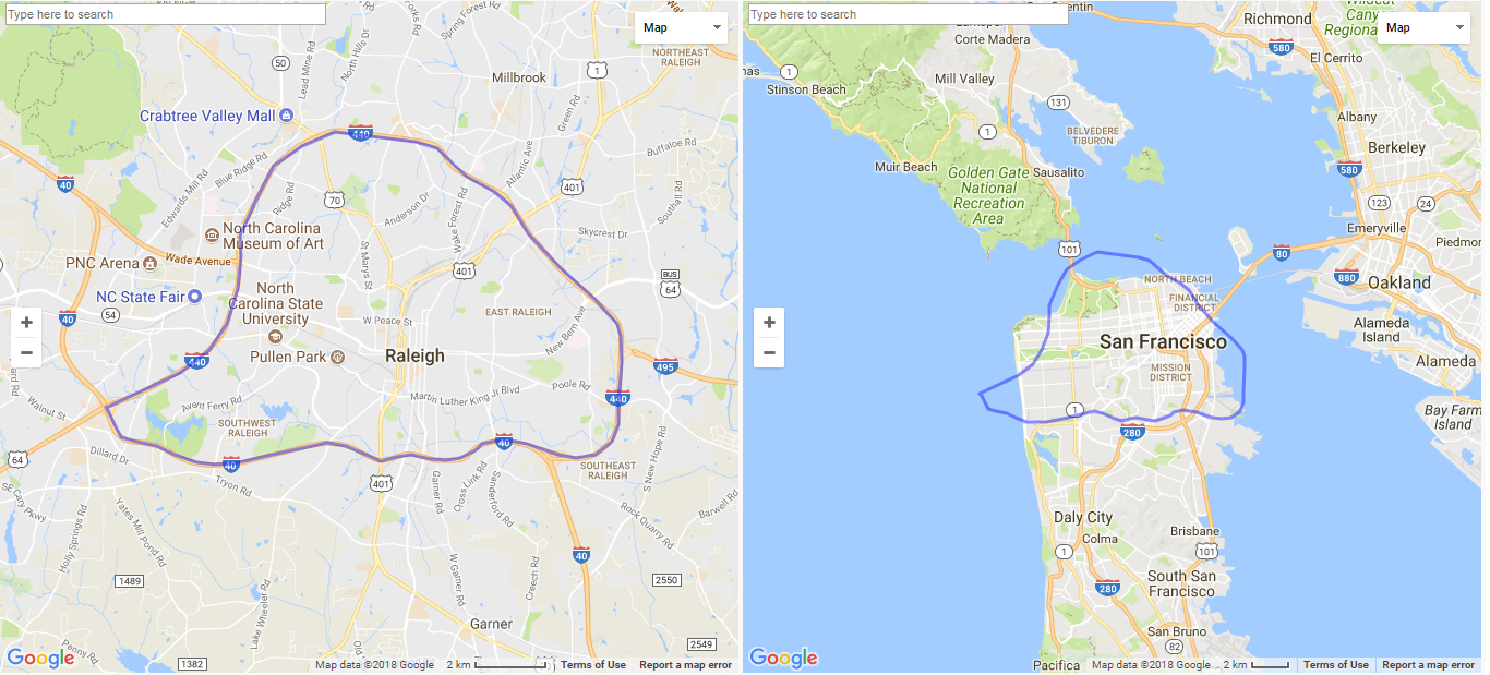
Good one! ITB is nearing the size of the entire city of SF. Even more sobering is that SF is physically larger than the entirety of Miami proper.
Here’s DT Raleigh compared to Charlotte’s downtown loop. This makes me really glad that DT Raleigh isn’t closely encircled by an Interstate.
http://mapfrappe.com/?show=54361
Think about it as the ORGINAL city planners did when designing the grid system encompassed by North, East, South, West Streets. They even planned agricultural districts south, industrial to the west, government to north, and white homes east and north, while blacks lived in south near their jobs
When the city was originally planned, slavery was in place. I’m not sure that there was planning for any segregated black community.
Remember when the City of Raleigh demolish a historic black neighborhood for a highway and called it MLK Jr. Blvd?
I did a very extensive project in city planning nationwide through all time periods focusing on Raleigh. I drew several compasses that replicated the growth and who lived in those districts. The footprint got bigger and we are not even close to full density of even our founders visions.
South Park and Shaw U are 200+ years ago planned. Every city natinwide had planned areas for all classes. Politicians, Workers, Aristocrats/Business owners, slaves. While their respective jobs were located close to where they lived and built.
In all seriousness RussMan, how were slave communities planned separately since they were under control of their masters? Shaw is the oldest HBCU in the Southeast, and was founded in 1865. How was that planned in advance over 200 years ago? I’m truly curious.
I saw in the progress how there was always what could be considered a “beltline” before interstate system arrived that allowed quick travel. I think since examples of having to build a highway in someones back yard we started messing up. Raleighs footprint is huge density comes from the heart of any city. Inevitably.
That’s really the entire point of this thread; Raleigh’s core is nowhere near its potential.
Comparing Raleigh to Miami, Miami is actually growing more rapidly, largely due to its core development. To put that in further perspective, Miami proper is less than 36 square miles of land.
I said through progress in growth and peoples success things like universities and schools were built to serve there communities. This reflects what came about as those areas thrived.
I even went to the NCDOT civil engineering department which had maps of these projects our original developers had . At least make a trip to City of Raleigh Museum.
I have recently been tracking nationwide east coast growth especially in relation to the interstate systems. Raleigh will be the sister city of Durham, and real unforseen picture shows areas along 95 will surpass expectations.
Isn’t Raleigh already a sister city of Durham? Which areas along 95 will exceed expectations?
Awfully put “Raleigh-Durham” I would consider. While being a local just as parts of town get a bad wrap Durham does too. But with that time Raleigh has quite the head start. Seeing the huge reality Raleigh is central but alot of left turns have to be made
If I had another 100 years to live I would own massive amounts of land Rocky Mount, Smithfield, Benson, Lumberton
@John this is an awesome site. Thanks for bringing it to everyone’s attention!
This is going to be incredibly useful for me in terms of seeing what the footprints of existing Major League Baseball parks would look like superimposed onto Raleigh (or anywhere else, I suppose), which is something that came up in another thread on this site recently.
I used to have to accomplish the same thing by using pencil to trace an outline on a piece of paper in Google Maps, and then moving the map, and then resetting it to the same scale. It turns out that this technique was actually reasonably accurate, but this is way, way more precise, and aesthetically pleasing. Thank you!
Great thread. I tried to think of some good comparisons but realized, I don’t know another city that I could lay good boundaries to their downtown core. Some, I could use highways but the locals may or may not agree.
Either way, without the maps, @John I agree. DTR is not saturated at all and there’s plenty of space to make it a great urban environment with unique districts.