Since we know that the City is thinking of extending West St. under the tracks to connect with the southern portion, I got to thinking about the road connections in downtown, particularly near Boylan Heights and the Warehouse District.
I read somewhere that someday the Cabarrus St. rail grade crossing will be closed, and this made me think of Harrington St. Currently it dead-ends just before Lenoir St., at one of the corners of the under-construction Fairweather condo building. There is some topographical difference between the two, but I thought that perhaps the connection should be restored. A glance at iMaps shows that it was disconnected sometime in the 1980s.
What do you think? Should the focus be on increasing the number of road connections, or just to leave it as it is and restrict the movement of cars? And what other connections should be discussed?
I kind of like the way it is now - with a pedestrian connection and no auto connection. The more of that kind of thing we get in the city, the more we favor walking over driving.
As someone that will be living on that south segment of Harrington late next year (we hope), I’d love to see a better connection to the warehouse district. I don’t think it’s a travesty it’s not there, and it’s easy to walk through where Tasty Beverage/Jose and Sons is to get there, but having either West or Harrington extend to Cabarrus would be pretty nice!
I like this topic and would push to get people thinking about it one step further. What do you mean by road connection? Does it mean I can drive through a certain point? Bike through? Walk through?
With scooters and electric-assist bikes bring that “middle speed” lane into the forefront I’d love to help create three maps for DTR. The driving map, the riding map, and the walking map.
When they say that a railroad closes a road I’m HOPING that only means for cars. I see no reason why there couldn’t be a safe pedestrian crossing for these railroads. They have these in Europe in a variety of places. Even if it’s a high-speed line (way in the future) trains will not be going through downtown at high or even moderate speeds so pedestrians crossings are feasible, IMO.
For me, the walkable street grid should be intact 100%. For personal vehicles (scooters, bikes, etc) we should have plenty of dedicated routes that get you to all 4 corners of DTR. As far as cars go, I think they can easily get to a more major street as a way to get around and in/out DTR.
I mostly agree, and it’d be best to make DTR as walkable and accessible as possible -for everyone, everywhere.
I see no reason why there couldn’t be a safe pedestrian crossing for these railroads. They have these in Europe in a variety of places. Even if it’s a high-speed line (way in the future) trains will not be going through downtown at high or even moderate speeds so pedestrians crossings are feasible, IMO.
Europeans are also used to having pedestrian-only walkways with a tram going through it. I’m not sure if it’s fair to have the same social expectations as Europe in an American setting…
Besides, if we’re looking to attract a lot of tech talent (esp. employers like Amazon, who don’t have the best track record of treating their lower-class employees well), I still think grade separation is a must -even for pedestrians. You’d have less noise (no alarms or horns when trains are coming), it’s easier for people in bikes or wheelchairs to cross tracks without having to worry about wheels getting caught, and it’ll be a good hostile design measure to prevent traffic accidents or suicide attempts (it’s a real thing). Either way, pedestrian-only at-grade crossings may be feasible, but I’m wary about the risks.
(I mean, if you’re modifying the intersections anyways, why not make more bridges or build over the rails? That gives you more accessibility and room for creative, new developments without having to worry about gentrification)
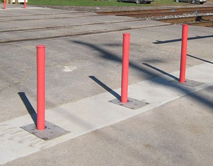
I completely agree with you there. It seems to me that when the time does come to close the Cabarrus St. crossing (and others), all that should be done is to install some bollards across the road so that the bike/pedestrian crossing is still intact but cars have to find another way across. This is the only picture I could find showing what I envision:
(I’m sure we could build better-looking bollards, though. The crossing gates would also remain in place as an extra precaution against bike/pedestrian accidents.)
Then just install some signs in the area to redirect auto traffic down alternate streets. Ideally, paint actual bike lanes on both remaining ends of the street that was closed to further cement its status as a viable bike route. Cabarrus St. currently has sharrows, but I think there is enough room on the north side between Dawson and West for a brief bike lane since parking isn’t allowed there. In any case, the new crossing would need to connect to a larger network of bike routes.
This would be a much cheaper option than tearing up the whole area to build a bridge or tunnel.
Wouldn’t this option still require the trains to legally need to slow down and blow the air horn? Since bollards can be removed plus pedestrians and bikes directly cross the trains.
That’s true, though I’m not sure it would be necessary in this location since the trains would probably still be moving very slowly after passing through Union Station. But I was thinking of permanent bollards that could not be easily removed.
I would love to see that. However, after working several years in the rail industry, I can say with confidence that the railroad will strenuously object to allowing any kind of traffic over the rails and will push to have it closed completely.
They have strong financial liability incentives to completely close as many crossings as possible. They can remove the signals, which are expensive to maintain. To accommodate pedestrians, pedestrian signals would have to be installed. Pedestrians strikes are a large portion of railroad fatalities, more so than in auto collisions, so removing auto traffic from the equation does not bring their liability down enough to justify the expensive removal of one set of signals and installation of ped signals.
So I think that the case for leaving Cabarrus open at the tracks is not worth fighting. You will be able to go one block south to Lenoir or just turn north on West. Not a big detour in either direction, even on foot.
There is something worth fighting for, though: for a connection to Davie Street to be included in the West Street extension. If it could be a full street connection that would be fantastic. I don’t think preserving those two story brick buildings facing Davie west of Harrington would be a good enough reason to oppose such a vital piece of connectivity. Let’s face it, the warehouse district is well on it’s way to becoming the Highrise District and I think that is a trend we should mostly embrace. Keep notable distinctive attractive buildings but don’t go to the mat for unadorned boxes, even if they are old and made of brick.
If a street connection is not possible for whatever reason I certainly hope some stairs can be put in.
At any rate this is not the place downtown that has the biggest connectivity issues.
My top two wishes for downtown connectivity are:
Morgan-Western connection south of Charlie Goodnight’s and west of Central Prison
Wade extension past the RR tracks and connection to Halifax
It is a big detour on foot if you can’t use Cabarrus. Your two options are either going up through Boylan Heights, which adds over half a mile or having to walk up Dawson right along the speeding traffic. Between Dawson and Lenoir there are spots where the sidewalks are super narrow and run along side a wall. It feels super unsafe and you never know when someone is going to decide to check a text, hop the curb and smear you against the wall.
There needs to be at least a pedestrian crossing at Cabarrus until the West Street tunnel is built (if it’s built.)
I agree with JosABanks that the detour on foot is definitely not as great as it sounds, especially without a West Street connection. I walked the Lenoir detour multiple times during this rail construction, and there are real issues with the sidewalks.
If you’re walking, jogging, or biking into downtown from the west, the Rocky Branch Greenway spits you out on Cabarrus. There are already bike route signs directing people to Lenoir or South, but most people want to go in a straight line. It really sucks to see your destination right in front of you but have to go out of your way to get there. This seems like the opposite of improving connectivity.
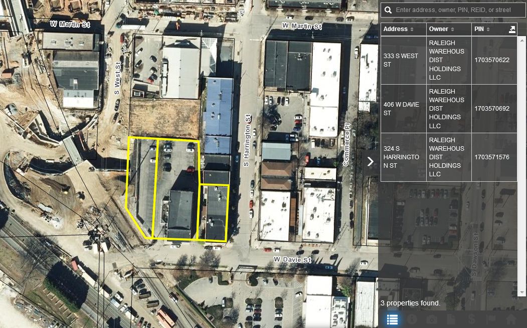
That may be possible, since the properties you mentioned were sold just under a year ago to a group that has plans for a large mixed-use development. If a street connection were required with that development and coordinated with the West St. extension, it could very well work out. But I wouldn’t hold my breath for it to happen, and a staircase might be the best we can get.
For reference, here are the parcels under discussion:
I’ve only made a cursory glance through the latest draft, but I was very pleased to see this sentence in the Introduction:
While the sections contained herein were developed with City’s and NCDOT’s Complete Streets Policy and the City’s GSI policy; some sections may vary somewhat from the NCDOT standards in order to be consistent with a certain land use or development type context.
||
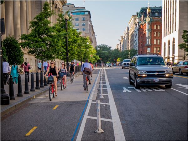
|# Try Out Raleigh’s First Cycle Track at Harrington Street Pop Up
Oaks & Spokes, in partnership with the BikeRaleigh Program and Raleigh’s Bicycle and Pedestrian Advisory Commission, will be testing Raleigh’s first two-way CycleTrack in Spring 2019. The three-day “pop up cycletrack” will be installed the first weekend in April from Friday until Sunday afternoon.
What is a cycle track + why do we need them in Raleigh?
A cycle track is a type of bike lane protected from cars, parked cars, and sidewalks by a physical barrier. By separating bicyclists from motor traffic, cycle tracks provide a dedicated space for bicyclists and minimize potential conflicts between people who walk, bike, and drive.
You are invited to come ride the test track, provide your feedback, and learn more about Raleigh biking!
Cycle Track’s Future
The longer-term project, which is a priority item in the 2016 BikeRaleigh plan, will serve as a key bicycle connection from Glenwood South to the Warehouse District via Harrington Street from Davie to Lane Street.
When: Friday, April 5, 2019
Time: 5:00pm
Where: Harrington Street: Between Morgan St. and David St. intersections.
It’s a wasted effort to ask for real protected bike lanes instead of bi-directional cycle tracks but I’ll keep on asking for them. In the end, I think I need to become rich and get into politics to make sensible changes to Raleigh.
That would be way it will work. 3 mode system will mean electric scooters and bikes will share.
There’s the sensible thing to do when creating bike lanes in an urban environment and I have not clue why Raleigh would choose an inferior design other than straight up ignorance.
Efficient, affordable, encourages people to bike and even walk more, and fewer cyclist deaths/injuries due to the inherent simplicity of use and separation of modes of traffic.
All the sense in the world–so of course you won’t see this implemented in Raleigh anytime soon.

 |
| |
|