Lake Wheeler south of Centennial/Farmers Market is a NCDOT road. They usually don’t install sidewalks unless the city pays for it out of their own pocket - though recently they did change policy to allow for installation out of their budget if there was a project along a road that they own but obviously that doesn’t help roads that have already been built and aren’t going to be widened anytime soon.
JoeZ you’re thinking of oak island lighthouse. Hatteras is brick. Hell they won’t even keep the regular pavement stripping in good shape, you think they’re gonna spend more for bikes.
The list of Bicycle Friendly Communities came out yesterday for 2019 (Raleigh re-applied this year) and Raleigh is still at the Bronze level. I’m honestly not surprised. Carrboro and Chapel Hill are Silver level.
Well, I’ve ridden through dowtown twice in the last week, including Friday at rush hour. Jones St, which has no bike infrastructure, still feels significantly safer to ride on than Person and Blount, but that’s entirely because of the amount of traffic. The new bike lanes are cool, they give me a place to feel like, when I am inevitably run over by somebody, at least I’ll be able to say I wasn’t doing anything wrong. Assuming I survive. Combined with the (really good) greenway network, I guess that’s good enough for a bronze rating.
Green paint or not, bike lanes are only as safe as the drivers in the area allow, and passive attention-getting techniques like green paint won’t convince anybody to put down their cell phones and pay attention to the road, so I guess I’m not sold on the notion that they’re necessary. But I’d like to see additional lanes anyway, especially connecting Chavis (where Little Rock greenway starts) to Person and Blount. South St would be ideal as it runs all the way down to the Rocky Branch trail where it connects to the prison and on to State. Maybe that’s already in the works?
Nothing for sure yet - ideally we would like to use Martin Street but as to which street that east-west connector eventually will be is up in the air until we know what the plans for BRT are (due to how wide the streets are downtown there are a bunch of streets that cannot accommodate both BRT and bike lanes)
If the requirement is that there have to be at least two lanes for moving cars and at least one lane for parking on every street, then that is true. If we open up the option to having just one lane for moving cars, or eliminating parking entirely, then it’s entirely possible to fit a bikeway and busway on a single street.
On streets like Hargett, Martin, and Davie, which see basically no through traffic on the west side of downtown, the one traffic lane option should be considered seriously. Yes, we just converted them to two-way not that long ago (2006 was… holy crap 13 years ago? Time flies! Maybe it was a fairly long time ago…) but let’s not fall victim to the sunk cost fallacy.
Absolutely true. NACTO has a bunch of really great renders on street cross sections (if anyone wants to geek out!). This one would work really well on Martin or Hargett. Note this is a 46’ cross section and we have 40’ (or less, West St necks down to 31’!), but if we did parking on 1 side of street vs. two, something like this would work very well for both Hargett and Martin.
Protected bike facility
Curb bump outs:
BRT lane
Parking lane:
Travel lane:
Sharing info from an email from Bee Person, Bicycle & Pedestrian Outreach Coordinator:
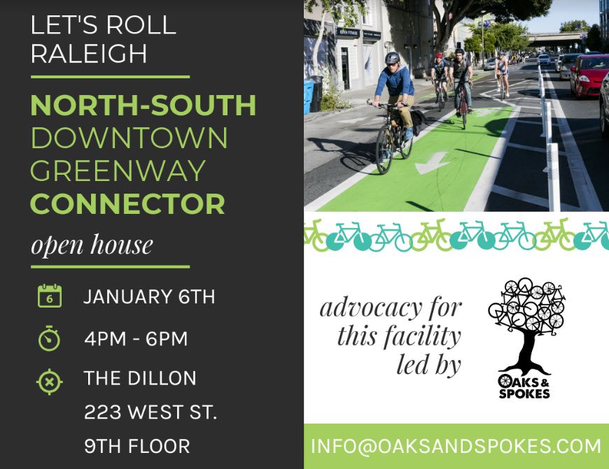
Learn about options for the Downtown North-South Greenway Connector that will provide bicycle infrastructure on streets in downtown Raleigh connecting the Glenwood South and the Warehouse Districts as well as two future greenways. This project was formally referred to as the West St. or Harrington St. Cycletrack, but has been renamed to more accurately describe the scope of the project. The open house will provide opportunities for public input on various options.
“but has been renamed to more accurately describe the scope of the project”
That sounds exaclty like what’s happening. I had a feeling Harrington St. wasn’t going to work and would eventually turn into a bike lane.
I was told the focus for the dedicate “Cycle Track” had shifted from Harrington St. to S. State St. near MLK BLVD.
At this week’s BPAC meeting, Paul Black, Raleigh’s Bicycle Program Manager suggested alternatives to a CycleTrack, including a Traditional (one way) Bike Lane on each of Harrington and West Streets to overcome some of the signal and safety challenges of a CycleTrack on one of the streets. I think alternatives are worth considering as they might be faster to implement. Hopefully these will be Protected lanes and not just paint.
The theory of the Connector is that these lanes should connect to the future Devereaux Meadows greenway to the North and Rocky Branch greenway to the South.
Providing some context, and a graphic to promote the event. Please attend if your schedule permits! The open house will look at multiple different design options.
Due to turning movements perhaps more difficult with many destinations along route (vs. long stretch where folks are traveling through)
Has more parking impacts then initially anticipated (road necks down to 31’ at points, most of downtown “Christmas Plan” is 40’, which is what staff assumed. Real world conditions have been different)
Would not be as long of a corridor due to issues with necking down at rail road tracks and light signalization coordination with NCDOT. For instance, 1st phase would be ~4 blocks. Not really connecting destinations.
Ability to implement more immediately with no signalization needs. As early as this summer if the community is in support and would connect from Warehouse District all the way up to Peace St.
Provides protected N/S corridor that is safe for all ages and abilities
Potentially reduces impacts to parking (staff is doing analysis currently)
I want to emphasize, this is NOT a watered down version of what you all saw before. In fact, if option #3 is selected, I believe it will be much better in the sense that we can get an installation done more immediately and cheaply (about 1/2 the cost, allowing for additional funds to be utilized for other key connection projects).
The desire in calling this an urban greenway connector is to have it literally and physically connect to our off-road greenway system. The commission has been working closely with staff to identify priority corridors through downtown that connect directly into current (Little Rock Trail > Crabtree) and planned (Devereux Meadows) greenway facilities, hence the rebranding.
This is a really exciting effort. I encourage you to reach out to me anytime with thoughts! I am the Bicycle and Pedestrian Commission Chair, for reference. Very open to feedback and thoughts and most of all want to encourage folks to attend this public meeting to voice support for protected facilities in our downtown.
That was actually one of my specific asks to staff, having green paint as a consideration for the entire corridor. I want to signalize to the City of Raleigh that we are doing something iconic and different. I also think it provides a really nice tie in with the greenway facilities and helps to brand our urban greenway segments, etc.
Now, how do we make @RaleighBikeLady the Downtown Raleigh CAC’s proxy for all things biking in DTR?? I’ve yet to disagree with her thoughts and she knows more about this stuff (and spenmds more time on it) than I can ever hope.
Hahaha, you’re funny. Y’all know I’m down to do a lil ad-hoc informal presentation at any of your mixers, or whatever you all think would be helpful. I can ping Leo on it. Really would like to connect with folks on how to make our downtown (and all of Raleigh) more people oriented by design and y’all are the perfect group to chat with on that. Lots of really smart folks in this group!
Ooohhh I like Option #3, provided that there are connections between the two 1-way routes on the north end/south end - @RaleighBikeLady I’m guessing that staff has said the 1-way cycletrack on West would be feasible even with the possibility of BRT?


 Please attend if your schedule permits! The open house will look at multiple different design options.
 Very open to feedback and thoughts and most of all want to encourage folks to attend this public meeting to voice support for protected facilities in our downtown.