Bike Lanes in and around DTR

What I can think of off the top of my head with remaining greenway connections that need to be made:

-Pigeon House Branch trail and getting a north-south route through downtown Raleigh
-Connecting the Lake Lynn segments to the rest of the network
-Somehow getting Northeast Raleigh linked into the system
-Durant Road connector so that you can bike from Shelley Lake to Neuse River Trail

(Also sounds like the new route around the old bridge - RIP - near Capital & Hodges will be done by next summer!)

5 Likes

I don’t know the specifics of what would need to be done to make this happen, but I’d like to see a comprehensive mapping of bike commuting access from throughout the city to several different employment and cultural engagement hubs like downtown, midtown, Rex Hospital area, Crabtree, Wake Med, NC State/CV, etc.
I know that the greenway system was originally envisioned as recreational during the “peak car” years, but it’s time to start leveraging that fantastic existing infrastructure for the future of the city. This isn’t to suggest that all of the possible commutes are supported by the greenway alone, rather specifically prioritizing on-street bike infrastructure (protected lanes) that extends the reach where the greenway ends or veers in another direction.

8 Likes

We’re still in the air about our office move to the PNC/Wade Park area, but I intend to start biking to work from NW Raleigh if/when we actually move. I think the Greenway System is one of Raleigh’s best assets and I intend to make the most of this resource. My goal is to bike to work 2/3 days a week, but that also assumes my kids FINALLY go back to school and I can actually go back to the office again.

Most of the commute will be along the creeks and Shelley Lake, but I am a bit concerned about getting from NCMA to the PNC area and avoiding as much traffic as I can. There are a couple of different ways to accomplish this, but I will have to decide which is the best route and which intersections are the safest to “Frogger” across vehicular traffic. Most likely this will be going down Blue Ridge Road (as best as possible) and cutting through Carter Finley/PNC parking areas to the tunnel under Edwards Mill Rd.

1 Like

Won’t help you immediately but coming soon in the near future:

(potential alternate route to the greenway, still would need to sidewalk hop between Duraleigh and NCMA though haha: https://raleighnc.gov/home/content/PWksDesignConst/Articles/BlueRidgeRoadWidening.htm)

In the meantime, from NCMA - I would go Reedy Creek Rd to Edwards Mill Rd, south to the PNC area. There’s a multi-use path/wide sidewalk along much of Reedy Creek (and it’s relatively low volume) and also on the east side of Edwards Mill, though crossing the Wade Avenue interchange is a horrible experience. Where is your office?

That was my Plan B option. :slight_smile: Can’t really say specifically where at this point, our RE folks are keeping us in the air and are discussing reducing our space due to post-Covid remote work options. I for one WANT to be back in the office again and get back to some decent network speeds. The new office will be in the general vicinity of PNC :stuck_out_tongue_winking_eye: I used to work in that area for a different firm and hated running up Edwards Mill towards Durlaleigh. Soooo many cars, and that hill sucks. Biking it will be much easier, but still sooo many cars. And there is zero tree cover up that stretch.

2 Likes

NE Raleigh’s connection will be Hare Snipe Creek. There is a huge culvert under Glenwood next to the Golden Corral office building parking lot that a greenway could probably go through. Connect from the Crabtree trail near there, through the culvert, and up to Wooten Meadows Park, and on to the corner of Leesville/Millbrook. Would like a better connection than at grade across Millbrook, Leesville, and Lynn, but that can come later I guess.

Another missing connection would be getting the Walnut Creek greenway extended to Cary.

Still another that I think would be fantastic but nobody at the city ever seems to care about is a greenway connector along the Beltline from Jones Franklin/Lake Johnson, up to Western Blvd.

2 Likes

Agreed that it would be nice to see Walnut Creek extended to Cary.

There’s also a few on-road segments of Walnut Creek that need to be filled in (around Trailwood - in design I think - and Little John Road).

Elsewhere, Gorman Street Connector is going to be going in soon, would be nice to see an improved crossing across Western somewhere (Dix Park please? haha), there could be improvements to better connect the greenway segments near Six Forks & Newton, also at Lassiter Mill.

1 Like

Let’s not forget about the Raleigh ARTery that’s been discussed on this site. Connector form Crabtree creek, through downtown, fix, and sour on to walnut greenway.

4 Likes

From my inbox to yours.

image

Separated Bike Lanes Coming to Downtown Raleigh
Construction begins Sept. 8

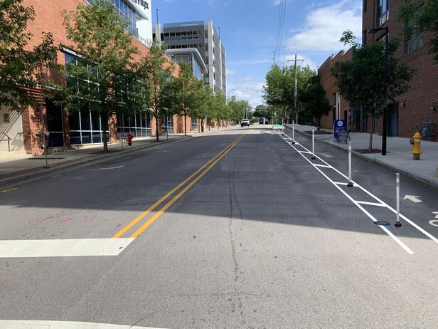
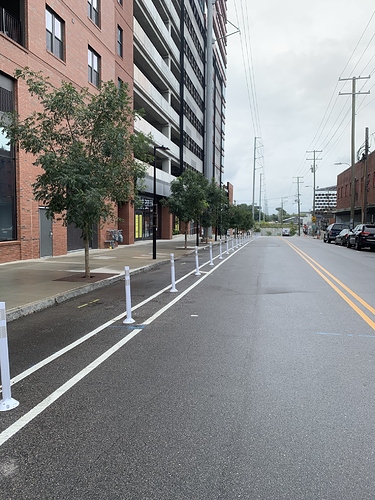
Construction of an important downtown bike lane project, the North-South Greenway Connector, is slated to begin Sept. 8. The separated bike lane project is the first of its kind in Raleigh, providing barriers between vehicle traffic and bicyclists. New bike lanes will provide a safer, reliable and healthy way to commute while helping to address increased traffic and parking pressures in downtown Raleigh.

“The 2016 BikeRaleigh Plan states that people of all ages and abilities should be able to bicycle comfortably and safely across Raleigh,” said Bicycle & Pedestrian Program Manager Paul Black. “Since many people feel unsafe riding with motor traffic, this new type of bike lane with physical separation between cars and bikes will help them feel comfortable riding to destinations in downtown.”

The long-anticipated bicycle lanes will connect Glenwood South and the Warehouse District, running southbound on Harrington Street and northbound on West Street between Martin and North Streets.

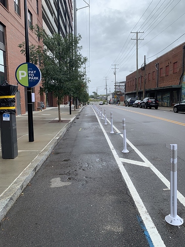
The new separated bike lanes will feature painted buffer zones with flexible bollards that give bicyclists more protection while signaling to drivers the potential presence of bike traffic. The bollards will also help discourage vehicles from illegally parking in bike lanes.

The separated bike lanes will expand the City’s bikeway network and offer access to seven bikeshare stations in or adjacent to each corridor. This project will connect to two-planned future greenways.

“The implementation of these lanes is an exciting addition to our growing bicycle network,” said, Transportation Planning Manager Eric Lamb. “Downtown Raleigh is such a desirable place to ride a bike, and the experience of using these lanes will be really enjoyable for our users. We look forward to building upon the success of these lanes and continuing to further grow our network across the City.”

To create these on-street bike lanes that physically separate motor vehicles and bicyclists, the following curb space changes can be anticipated:

  • some downtown on-street parking will be permanently removed along both Harrington and West Streets; and
  • some commercial loading zones will be relocated; and
  • two additional accessible parking spaces will be created.

NPS Solutions, LLC, is the contractor for this $200,000 project. The Sept. 8 planned start of construction will begin with the West Street corridor with work being completed block-by block, completing West Street before beginning work on Harrington Street. Both separated bike lane corridors are anticipated to be completed by early October.

Traffic Impacts: Traffic delays along both the West Street and Harrington Street corridors should be minimal. No road closures are planned. Drivers should proceed with caution when approaching the construction area as flaggers will on-site to direct 2-way traffic through the work area. For businesses that currently have curbside pick-up on southbound Harrington Street or northbound West Street, pick-up locations will need to be shifted to the other side of the street to accommodate the new bike lanes.

Construction will move quickly to complete the full project in approximately one month.

We appreciate your patience and understanding through this construction process. We believe that this project, once completed, will be a huge benefit to our community and greatly improve safety for motorists, pedestrians and bicyclists.

Learn more about the Downtown North-South Greenway Connector project.

20 Likes

Awesome! Maybe I missed a meeting or two, but did this recently change?
A couple months ago I thought S. State St. would be getting the first separated bike lane and Harrington St would be later. Now its two streets southbound on Harrington and northbound on West St. between Martin and North (Dillon to West buildings). Also says this will be completed within a month, this is going to be a huge catalyst for connection between Glenwood south and the Warehouse district!
I’m just curious how the bike lane with navigate crossing Hillsborough and Edenton streets.

2 Likes

Apparently State Street got pushed off to the side because it got some lukewarm reception from a small handful of people at a CAC meeting. Still hopeful to get some sort of facility in that area sometime in the near future.

There was little support among businesses for removal of all street parking along one street (pre-COVID LOL) so it was decided to do one-way pairs with this configuration working out because it didn’t put cyclists in conflict with the Capital Blvd ramp on Harrington

The Harrington & Edenton St intersection isn’t going to be pretty but at least Edenton St is a one-way street. (At this point, I’d rather see something on the ground other than try and haggle NCDOT for some signals). At Hillsborough, cyclists will just follow the signals along with everyone else.

2 Likes

I thought NCDOT was reviewing bike-specific crossing signals for approval statewide, to be used in this project? It’s such a shame that simple improvements to non-auto infrastructure are so hard to implement.

I’ll take what we can get, but surprised they are not taking this all the way to Peace to connect with the future Deveroux meadows park.

Perhaps it’s not good timing right now with the Smokey Hollow area still under construction? The bike bath construction schedule is pretty imminent.

1 Like

yeah, I honestly have no idea what ever happened to the bike signals and NCDOT - someone would have to ask city staff on that one.

(Edit: Apparently the city did get approval for the bicycle signals from NCDOT but since it’s now a one-way pair, they’re no longer needed, they would have just been needed if it was a two-way cycletrack facility)

Yeah, I think the reason it’s stopping at North Street is because of the construction in the Smokey Hollow area. Hopefully in the near future it can get extended that all the way to that greenway crossing at Wade Avenue.

1 Like

They are - that will be completed once the construction is finished. Don’t want to add bollards with all of that heavy machinery onsite (would get damaged). Will be added once construction wraps up. The bike signals were not added because this is not a 2-way cycle track, so the bikes will go with normal vehicular traffic and don’t need their own crossing signal. You only needed that modification with 2-direction bike traffic. Also - it was slowing the project down - a lot :wink:

7 Likes

These are going up quickly.

22 Likes

I mean it really is that simple. If people get over the fact that there can be fewer lanes and fewer parking, we could easily put up miles of similar facilities to connect the city for the price of a single roadway project.

8 Likes

Right - Installation is the easy part. Getting to installation is the part that takes years.

2 Likes

Parking decks may now get some use finally. I wonder how much the city spent to study the implementation of a $500 worth of street paint.

2 Likes