I actually took the survey! (The signs posted next to the sidewalk with the QR code made it very convenient to do so.) I just noticed that it was not mentioned in the 10-year plan you linked, so I thought I’d ask. I assume then that the 10-year plan just isn’t intended to cover projects that are already in-progress / ongoing?
4 plus years public engagement… Sounds about right to get even the smallest idea implemented in Raleigh…
I live in a neighborhood off of S State next to Walnut Creek. The street (State) is nice and wide as pictured above and so adding the bike lanes is cheap and easy, BUT, more to the point, traffic speeds like hell on that stretch of road BECAUSE it’s nice and wide and quiet, so it isn’t safe to walk on. The sidewalks are pretty messed up, too. This is also a majority-black community so NOT doing anything in this neighborhood–while completely typical for this city–would be a bad look right now. I’m sure the project got moved up quietly because it’s both shovel-ready (no shovels needed) and has good optics. Now what would really be nice is better street markings where Little Rock Trail crosses Bragg, and some repaving over tree roots and stuff, but that’s not on any agenda I’ve seen. Little Rock really needs some attention from the city and it IS the only existing greenway that actually bumps into downtown, but it doesn’t seem to get any love.
Also think about the Walnut Creek Wetland Center, which is directly on State St and so is another sort of “destination” that these bike lanes will connect to. There is also currently no connection to Biltmore Hills (the neighborhood south of 40), which has a big park that the city is spending a bunch of money on to build fancy tennis courts at (why I don’t know), so they need to improve the connections to that park from the rest of the city, and this is a part of that.
But, ultimately, truth: poor people need better pedestrian and bike connectivity to the rest of the city MORESO than rich white people do right now or indeed ever. Our sidewalks are consistently used by people who actually need them to travel from place to place in our community, not just by people out for a jog. The fact that they’ve been allowed to get so cracked up and overgrown is something the city should be ashamed of, though clearly nobody is. It’s nice to finally see a little bit of attention come this way.
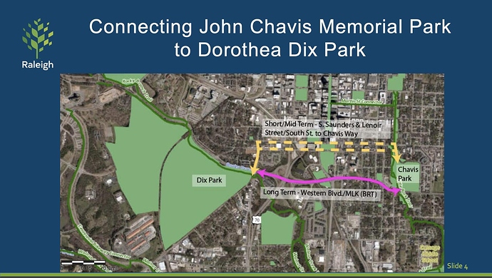
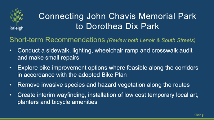
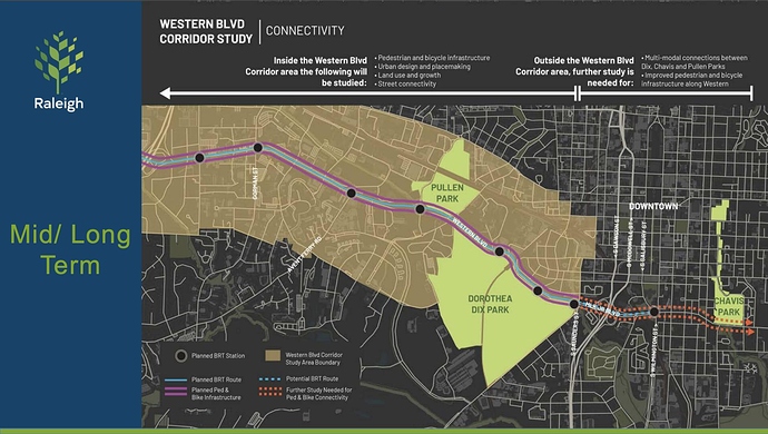
Well, here’s good news for you, then: Parks and Rec is looking into fast-tracking greenway connections between Chavis and Dix parks
Phase 1 happening in the 2030’s or this decade?
These were all good outcomes from the most recent Council meeting and thank goodness for the Dix Conservancy or none of this would even begin to take shape in our lifetimes… 
This is all wrong. We need a gondola.
Chavis > NCAE/Salisbury Square > Dix Park
That, or some kind of elevated tram system (like Disney World lmao) would be so sweet. Connect all three parks (Pullen x Dix x Chavis) via tram/gondola, plus the land bridge over Western connecting Pullen and Dix for foot traffic, and voila - we’d have a Nationally renowned tourist attraction. Bonus points if Dix builds some kind of ferris wheel or observation tower, and another observation tower at Chavis.
I agree in that a gondola system would look cool.
But would it actually get people where they need to go (as an alternative to cars)? What need and what corridor would it serve? A part of why the R-Line and downtown BRT routes were so hard to plan is because there’s not a lot of linear patterns for where people want to go. Aerial ropeways still operate in linear routes, so unless y’all know of a clever route pattern, I can’t imagine how that would make things better.
Shifting topics… in an unprecedented turn of events, the Regional Transportation Alliance is now considering advocating for tactical urbanism. Not holding my breath, but still… those guys have a lot of sway.
I don’t think they were ever against it per se, but it’s good to hear they’re explicitly advocating for it now! The big question, then, is where is a good place to start a temporary bus lane in Raleigh…
Also, I wonder if that’s actually one of the suggestions made by the FAST study that Milazzo etc. got to preview behind closed doors.
Wouldn’t be too much fun in a pop-up thunderstorm.
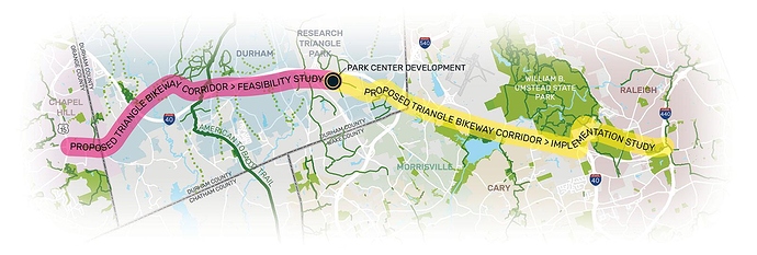
Listening in on the CAMPO meeting… there is now a site for the Triangle Bikeway Study. Check out trianglebikeway.com.
Isn’t there also a plan to extend the Crabtree Creek greenway up to Umstead SP? That would be another way to access this corridor from N Raleigh.
Thanks for sharing @dtraleigh
The Crabtree Creek trail basically already goes to Umstead. You take Crabtree to the House Creek trail, the House Creek trail to the Reedy Creek trail and wallah you’re in Umstead.
This is what I was talking about:
The Crabtree West Trail project is funded by the 2014 Parks Bond Referendum.
The Crabtree Creek West Trail is the remaining trail section of the Crabtree Creek Greenway corridor and will extend from the existing terminus at Lindsay Drive to the eastern boundary of Umstead State Park on Ebenezer Church Road. This proposed trail section is approximately two miles in length and is a critical link in a regional greenway system, connecting multiple neighborhoods and business centers in Raleigh.
Whoa, this looks like a very fun and functional Greenway segment! I like the switchbacks going up from Richland Creek.
crabtree-creek-west-trail-approved-alignment (1).pdf (663.9 KB)
The Triangle has a great Greenway system. I love that they are connecting the major pieces. Thank you for sharing about this segment.


