Um, those photos look like European cities - isn’t that cheating? 
The cycle track design may not be the best, but if it ever does get built I’m going to make a point of riding on it to be seen as a cyclist using cycling infrastructure.
Um, those photos look like European cities - isn’t that cheating?
The cycle track design may not be the best, but if it ever does get built I’m going to make a point of riding on it to be seen as a cyclist using cycling infrastructure.
The bike lanes in Seattle were a lot like this. There were spots where they were at grade and some where there was a little separation. strong text
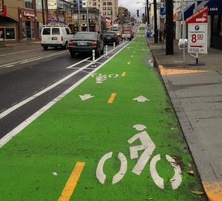
Oooo, I wanna share a bike lane I’ve ridden on in Montreal.
Raleigh, take note! That looks amazing.
While we’re sharing stuff. . . check out this video from Jeff Speck on proposed changes to Boston’s Kenmore Square.
I can’t imagine trying to bike through the square in its current configuration. At the 3:32" mark the video gives an animated look at what that experience currently feels like.
According to People for Bikes, more than 100 US cities have protected bike lanes. Google sheets list here:
Only NC “city” on the list? Kinston, NC.
This is low-hanging fruit Raleigh. Grab it.
I’ve actually ridden on the protected bike lanes in Kinston (went to a conference in New Bern and stopped by on the way back to Raleigh while I was making a pit stop at Mother Earth) - it doesn’t really go anywhere but it was cool to see
(can see on the Google Maps aerial - Atlantic Ave in Kinston near the intersection of Nelson St) - Google Maps
Stewart here in Raleigh did the design for that: http://stewartinc.com/ncs-first-two-way-separated-bike-lane/
What are their criteria for a protected bike lane? It seems as if a lot of quality bike infrastructure (greenways, etc.) could be missed depending on how they define a protected bike lane.
The better terminology is a “Cycle Track” - Cycle Tracks | National Association of City Transportation Officials (bike lane/street separation vs greenways)
That’s a really good question. It seems as if the record of protected bike lanes methodology is all over the place and relies on a case by case local description of the method.
The one thing that does seem to be consistent is that it needs to run parallel to vehicular traffic. IMO, the bike trails as alternatives to get from point A to point B should clearly be included since they are infrastructure for bikes that are even safer than riding alongside a motorist.
“Technically” the greenway system in Raleigh is closed to the public after dark (though people like I obviously still ride after night). Also they are closed to motorized vehicles like e-bikes/scooters/skateboards. I think those 2 things might be barriers to calling them actual transportation routes.
Speaking of low hanging fruit, creating night routes along the greenway would be a terrific way to increase bike infrastructure.
Well the biggest greenway problem currently is that it’s not a reliable route. It’s along creeks/rivers so it’s always flooded whenever there’s a major storm. There are several structures that have been washed out too with the major storms (currently you can’t get from Five Points to East Raleigh because the bridge near Capital Boulevard has been out of commission consistently for more than 1.5 years now). Not to mention the Crabtree Sewer Replacement project has closed several greenway sections as well (some without a detour route).
https://www.raleighnc.gov/parks/content/PRecDesignDevelop/Articles/GreenwayRepairs.html
I agree that unreliability is the biggest problem. Even if we could get protected bike lanes to connect through downtown to the greenways, their unpredictable status makes the greenways not a viable commute route.
It seems that having a 6 inch curb along the creeks would dramatically improve availability of greenways after rains and reduce the maintenance costs.
Does Raleigh not already have something like that? The Centennial Bikeway Connector seems to satisfy that requirement.
That’s a really good point. Why wouldn’t that bikeway connector be considered a protected bike lane? Is it just because the city isn’t tooting its own horn and submitting the data or designated it as such, or is because it’s not painted with indicating green markers? It’s certainly more protected than the one is in Kinston.
Could it be maybe that it’s more of a shared path that can also be used by pedestrians? Rather than solely for bicycle use.
That could be the case, but then why would it be called the bikeway connector?
I am regretting that I had already submitted my city of Raleigh budget survey. What Raleigh really needs to pay attention to is tooting its own horn. The city needs someone who stays on top of the data and reports it. Heck, even the Raleigh Wiki page is pathetically outdated and tired. The city needs to hire some sort of analyst/social media specialist.
Well I guess that’s the “name” but since pedestrians are also using it, it’s classified as a shared use path and not a dedicated bike lane. There’s also no markings to indicate that it should be solely used by bicyclists.
Then the city has an excellent opportunity to widen it and make side by side bike and walking paths. For me, this is a no brainer & a quick win.