So here’s something I’ve been chewing on for a while…
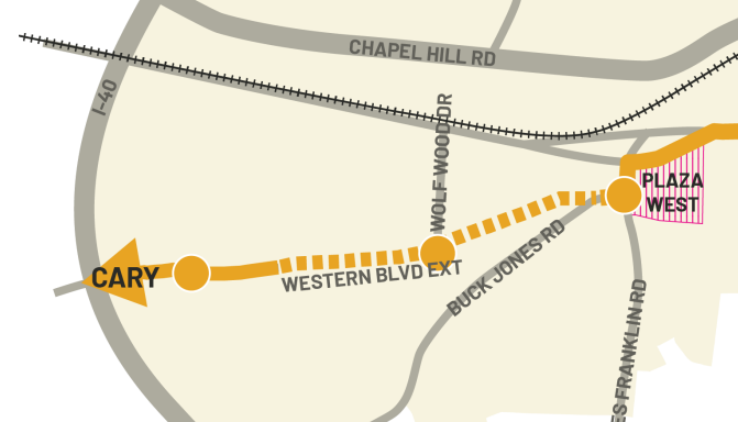
The Western BRT route is supposed to utilize the planned extension of Western Blvd, right? I’ve poked around this extension on Google Maps, and, as y’all know, the City already has most of the ROW for this. However, there are two problem spots: the intersection with Buck Jones and the intersection with Irelan and Bashford. It seems to me that, in both instances, existing homes will need to be demolished in order to make this happen.
I know the City can utilize eminent domain if the homeowners refuse to sell. However, doesn’t that leave the possibility of lawsuits, which could drag this on for years? With multitude of TOD opportunities along this route, this has the potential to become one of the most critical pieces of the entire Wake Transit Plan. Why, then, would the City choose such a high-risk option? Am I missing something here?
Edit: found a third conflict. There’s a random house smack in the middle of the route, blocking the completion of Burton Ave. Looks like the southern portion of Burton is still mostly gravel and private (there’s no street view available, either), so my gut says that guy is gonna do whatever he can to maintain that property.
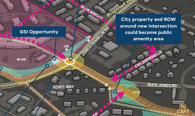
Second Edit: can someone tell me what “GSI Opportunity” means? There’s like two others in that same map (outside the screenshot I took), and it’s been driving me nuts.
I wouldn’t worry too much about owner hold outs. It may drag things on an extra year or so but I haven’t really seen a true project really get derailed by 1 owner.
The intersection area with buck jones will be interesting to shake out. I’d assume they want the Western Blvd corridor to be cohesive and not face two road changing turns.
Ah, good to know. I know very little about litigation and eminent domain proceedings.
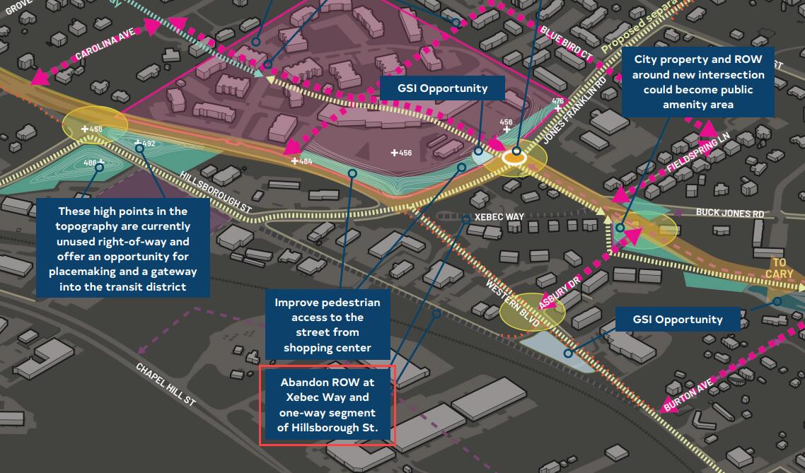
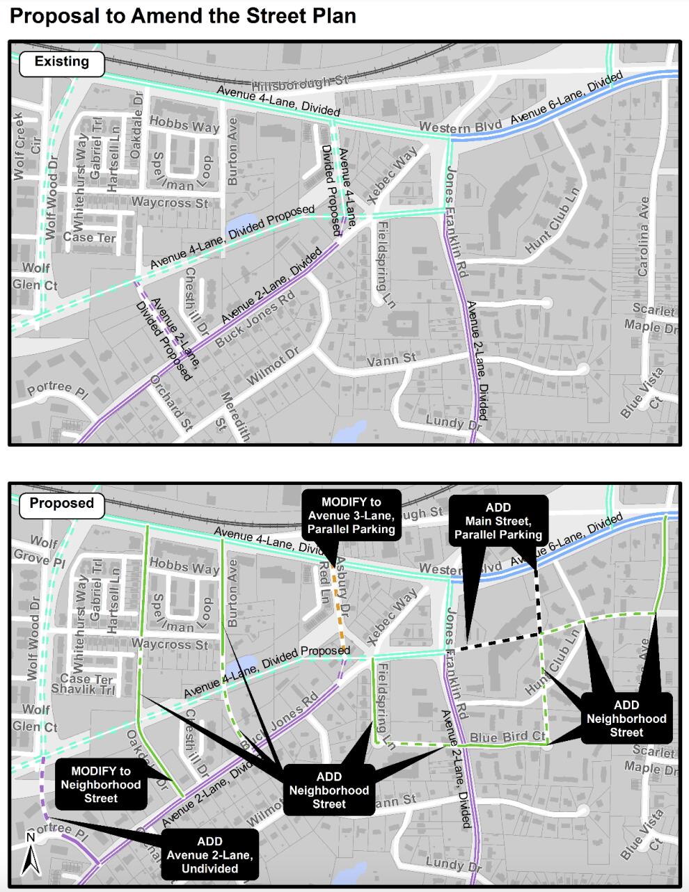
And yeah, that’s kind of what I thought they were gonna do. Instead they’re planning to abandon the ROW for Xebec Way (highlighted below, source is pages 116-117 of the Western Blvd Corridor Study Report). Odd move.
Eminent domain tends to move very quickly once environmental documentation is certified. Lawsuits to stop it must happen before that. Past that point, the only recourse is for the (former?) property owner to file suit over the amount they were compensated for the loss of their property.
This Western Blvd extension has been in the comprehensive plan for decades. It was in the thoroughfare plan map as a straight through connection, but with a rather imprecise specific location.
Maybe 10 years ago they did a small area plan to figure out how to tie this all together, and the two-street jog you mention wound up being the outcome. And that’s why it’s been shown in BRT plans until now, but it was settled before Western Blvd BRT was a thing. So there’s a chance they will rethink it during the BRT study.
EDIT: If so, it seems like the window to that opportunity is closing now. The high-level design has been completed (read it here!), so it’s in the hands of city decision-makers now. See my other post below.
Thank you! Based on the locations presented, I had a feeling it had to do with stormwater, but I couldn’t for the life of me figure out what the acronym was.
Well, it turns out the Western BRT Corridor Study is wrapping up, and a draft of its findings will be up for discussion. City staffers are asking for additions to its street plan, and the proposed changes imply that the two-street BRT maneuver is here to stay.
It looks like the road layout is being made/kept that way for a reason: grid layouts of roads are expected to bring denser developments that are transit-friendly and have plenty of open public spaces. It seems like the Western-Jones Franklin-Buck Jones intersections could have no more than 2 of these three options:
be made into a grid
have traffic smoothly
meaningfully enable open, public spaces
The Planning Commission will also talk about a related request to remove a road from city street plans that could’ve linked Jones Franklin Rd. and Chapel Hill Rd. A related decision from 2019 cited existing businesses as one of the reasons why that underpass idea got axed. I wonder if that meeting also clears up how we ended up the way we did.
It’s for sale, along with its neighbors, as a development site. Not sure why, but most of the Farmgate lots are also marked for -TOD overlay – maybe trying to encourage redevelopment, which would result in the city getting the ROW.
We live in that area between bashford road and buck jones (We bought a small townhome there ) and I really don’t like the idea of killing our forest here with all its wild life (raccoons, owls, foxes , turtles etc)
But as somebody mentioned here 1 owner can’t oppose that project. We gonna get one more dusty and noisy road right in our backyard running buses nobody rides in.
I would build more greenways rather than BRTs etc since in the post pandemic world people won’t need offices and malls.
It was pre-pandemic, but I’ve been on the GoRaleigh 1 and 8 buses a few times and have seen them be at least 2/3 full on weekday evenings. I think it just depends on where you live and what bus stops you’re looking at. Same goes for the GoTriangle, GoDurham, and Chapel Hill Transit buses I use more regularly, but I doubt y’all care about that.
Anyways, people don’t ride buses that are not convenient for them. That’s the whole mission behind BRTs: Raleigh is trying to make a mass transit solution that’s convenient enough that people will use them. The service kickstarts demand (which includes future development opportunities that the real estate world is actively keeping an eye on), not the other way around.
We may need them less, but that’s different from not needing them at all. I agree that there’s cases where greenways can be more useful, but there’s times and places where it makes more sense to have ways for lots of people to commute together efficiently.
Yeah, I’m just not sure it will ever come back. I live downtown and just never see any buses with more than 5 or 6 people. Seems like such a waste of resources .
Most of our routes also don’t start and end at major destinations. I would think you see the bus start reasonably “empty” and then pick people up along the way. I think the same metaphor for driving is the commute patterns in the morning vs afternoon so it definitely depends on when and where you are catching the bus if you want a visual indicator that “the bus is full”.
I think that is right. If you go to the Walmart on New Bern and ride a bus into downtown at 7AM or 8AM it is very likely to fill up before hitting downtown. I have been thinking lots about the BRT routes because I am an ambassador for my neighborhood and the New Bern one. I hear a lot about how that one is empty, but the current route averaged like 1,500 rides a day back in April 2021(the latest data I saw) which seems like a lot for some buses. The BRT routes are kind of made to be ones that would have good ridership because they are set for such central routes directly North, East, West, and South. North and East are already the most used and the few times on was on the east one after work heading home, it was standing room only.
Kind of a side note, but perspectives are interesting. I used to ride the bus to work every day, and no one really wants to ride on a full bus where you might need to stand, but people who see buses think it is bad when they don’t look packed.
The BRT system isn’t about getting people to offices (besides downtown, it’s not really convenient to many offices), but it does touch a lot of “essential worker” job centers like WakeMed and NCSU. It also touches a lot of retail areas – important because non-work trips are 80%+ of all trips, and oh, in-person retail sales are actually higher than they were pre-pandemic.
Also:
NOT building BRT and infill housing will kill 10X more wildlife and forests. Building BRT and TOD here makes it possible for the same number of people to live on 95% less land than in the suburbs. That means 10X more wildlife and forests.
The Western Blvd Extension was shown on road maps in the 1980s. The city has been buying that land for generations. If that’s a surprise to you, that’s your fault for not doing due diligence before buying.
How many hours each day are 100% of the roads that you see 100% full of cars? How often are any of those cars 100% full, with every single seat occupied? Why apply this standard to buses, then?
Most of the cost of a bus is for the driver, not the vehicle. Smaller vehicles aren’t much easier or cheaper to run.
I’ve ridden buses around here a good bit over the 2 decades that I’ve lived in the Raleigh area, and I’ve certainly been on my share of buses where it’s like me and 2 or 3 other people, and I’ve also been on my share of buses where there were few (or no) open seats to be found at all - sometimes on routes where it figures (like the Wolfline, or GoRaleigh #1, or the GoTriangle #105) and sometimes on routes you wouldn’t have expected at all (like the GoRaleigh 70x from Crabtree Valley to Brier Creek, on a Saturday, if you can believe it.)
But mostly it’s somewhere in between. Like 8 - 15 people on board. These buses have seats for about 40 people, so with passenger loads like that (1/3 to 1/5 of the seats taken; no standees), they look and feel pretty empty, both from the inside and outside. These are the buses that conservatives see and complain “Nobody rides the bus! What a waste!” - but is it actually a waste? They are a dozen or so people who might not be able to get to work otherwise, or might be driving and creating traffic, or parking and taking up spaces (and space!) at their destinations.
You can say it’s a waste to be running all these big 40 foot buses when only a dozen or so people at a time are ever usually on them. A van would do, right?? But then you get the odd instance when 30 people from the women’s shelter out by Ebeneezer Church Road all decide to go to the mall at once on a Saturday afternoon. So when that happens, you’re glad for the extra capacity!