12, 4, and 16 are plenty busy when I use them to get groceries from HT or Target. 6 as well. Anyone that says the buses are useless or empty have an agenda.
6 Likes
As someone said earlier, highways mostly not a full capacity, and most cars are rarely at full capacity either.
7 Likes
About four years ago I rode route 8 to work 2 or 3 days a week. Leaving around 7 and returning around 4, it was solid attendance. That was a while back on a chill route reverse commuting out of downtown to a bit north of north hills. I’m going to look on data of bus ridership and cost analysis. These are interesting points and i always want to see the numbers.
1 Like
I rode the bus for 5 years to downtown Honolulu. It was Full the entire way. Why, because it would take people two hours to drive the 30 miles in a car. Too many cars on the island. That is when the Joyful Buses fill up, we may get there but no time soon.
I found this list of reports.
https://raleighnc.gov/raleigh-transit-authority
Scroll down to see January 2020 reports, preCOVID
I looked at January and found data
What I cannot understand is what is a good comparison of riders/mile or passengers/hour. What are the goals and what are industry standards?
3 Likes
For passengers per hour you definitely want ten as a bare minimum, twenty is pretty good. The Wake Transit Service Standards are a helpful resource, too.
Wake Transit Service Guidelines.pdf (1.7 MB)
5 Likes
Look at the #21 between downtown and the Farmers Market with 54.5 riders per hour
3 Likes
i know my folks who couldnt drive rode the bus all their lives…they needed it. but for some groups a targeted transit option the city could or may even now offer, while scaling back some vehicles. i thought the city had some vouchers for teh disabled for cab rides that my folks used for years.
1 Like
On Wednesday, the city will release its draft station area plans for the New Bern Av. BRT corridor for public comments! They’ll also hold a hybrid meeting about this online and at the Tarboro Community Center that evening.
More on this in this N&O article.
Most likely, the drafts will be refinements on what the city discussed with residents and stakeholders last October. Here’s some key things I found from those meetings’ slide decks and StoryMap; click each dropdown and link for the appropriate slide:


From DTR to East Raleigh
- More neighborhood sidewalks and shared-use paths are proposed
- St. Aug. and “Black Main Street” could be maintained and revitalized through more commercial and housing opportunities
Through WakeMed and old money neighborhoods
- The big idea is to gradually add density to buildings as you approach downtown.
- Trails around Enloe High School could be expanded
- Poole Rd. could get 1000 new housing units (market-rate and/or subsidized?) and 100k sq.ft. of new commercial space
- Senior housing across the street from WakeMed might also be possible?
Beyond the Beltline
- BRT-related developments can incentivize Neuse River Greenway connections and green spaces
- Opportunities for dense, walkable developments already exist today, with more on their way
- …with even more opportunities 10-20yrs in the future
- More east-west foot paths and bikeways are planned so you don’t have to walk along New Bern’s curb
- The little things also help with walkability and safety, too.
10 Likes
Dropping this here as well, since it’s applicable.
https://community.dtraleigh.com/t/residential-infill-along-new-bern-edenton/358/615
4 Likes
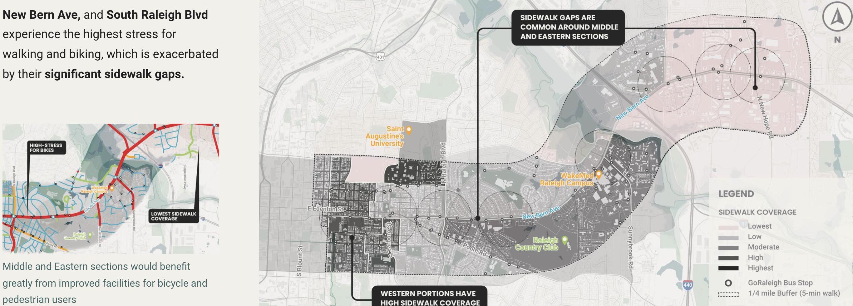
This checks out with the presentations and discussions they had earlier this year. It’s cool to see their recommendations in more detail, though, especially where they specifically identify where, how, and why rezoning and infrastructure upgrades should happen!
For those of y'all who didn't read the draft plan (even though it's not very jargony or hard to read), click here to see what I thought are the important slides.
Engineering consultants at Stantec think, in broad terms, the New Bern corridor’s land could be used like this:

People will still need ways to walk and bike from BRT stops to their final destinations, including greenways. Here’s the latest map of where they could be.

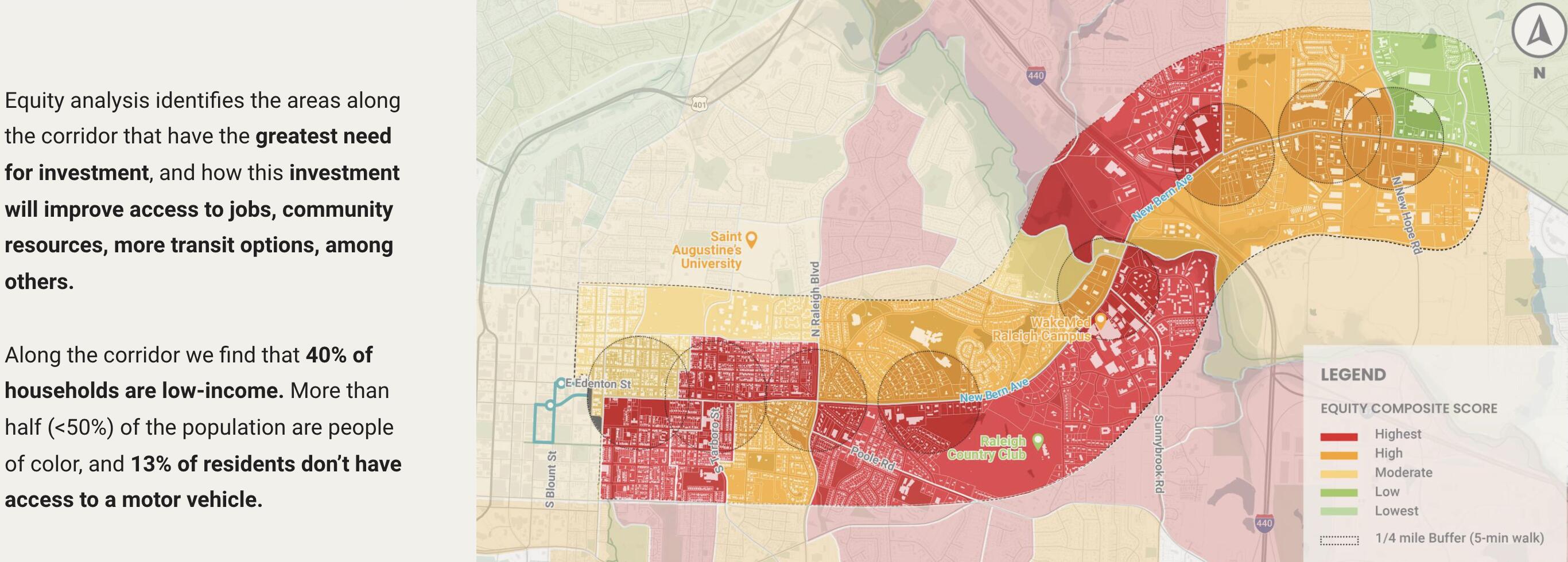
Those paths would enable transit-oriented district (TOD) overlays to be placed in these places:

Those overlay districts could encourage the following density bonuses:

To meet this vision, six parcels would need to be rezoned:

Not everyone will automatically live and work and move around at their best, though, just because you build BRT. Stantec also thinks these additional investments in mobility and these strategy changes for community and economic development are just as necessary.
11 Likes
Fuzzy mind but does the New Bern BRT have a final street plan yet? Is it still a single bicycle/pedestrian path on one side of the corridor? Surprising how hard that information is to find online.
1 Like
No, because the draft street/area plan (see above) is still up for public review. You might as well read it and add your thoughts:
Note that this is the same one that @colbyjd3 posted in the surveys thread where some people are making ham-fisted comments about community investments and racial equity.
8 Likes
I am just going to come clean and say that I had to Google “ham-fisted”.
1 Like
When is actual construction supposed to start?
1 Like
Website shows the New Bern BRT construction will stat Summer 2022!
8 Likes

So……….summer 2023.
2 Likes
Need more studies and surveys first
1 Like
Those are huge houses on huge lots, and it would be marvelous to infill behind/beside them. But aren’t there restrictive covenants on them? @ADUsSomeday
3 Likes
There is the NCOD overlay. Which I guess might be removed from those properties? Interested to see how it plays out. The whole missing middle changes recently essentially played out so that when before you could only have one home on 0.7 acres you would not have a duplex or triplex on the same size lot (but not multiple buildings).
It seems like the stuff that TOD envisions would need to be more than you could just squeeze in with the NCOD in place. Not sure how it will play out.
1 Like