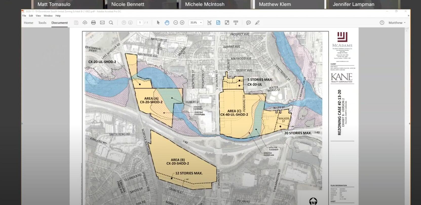
Downtown South plan seems to have been revised. Track A and B down from 40 story zoning to 20 or less, Track is will only be 40 stories in just a portion urban area.
Half of the planning commission seems anti-Downtown South no matter what.
Downtown South plan seems to have been revised. Track A and B down from 40 story zoning to 20 or less, Track is will only be 40 stories in just a portion urban area.
Half of the planning commission seems anti-Downtown South no matter what.
I agree with you . On a positive side , I think enough council supports this Project . JMO
Trash nothing but trash
No John, I was not referring to you. Although you are a big baller in the DTR blogosphere I don’t think you would have power to change the Kane lobby TV from Fox to MSNBC. Was speaking about the process.
City Council members are probably generally supportive of this project, sure. But they’re not the ones wrestling with every design and engineering detail.
That’s the job of the Planning Commission, and that’s what Francisco is talking about now.
How did you get to that conclusion?
The public comments that took up the first 2/3 of yesterday’s meeting were from individual citizens with different shades of criticisms. I think it’s fine to say the more rambling ones are just NIMBY obstructionism.
But what made you think the arguments between commissioners were a part of that, too? The conversation between chair Matt Tomasulo and commissioner Michele McIntosh about how to measure land usages and how to bake in park requirements. Nicole Bennett’s suggestion about the traffic study in the end, on the other hand, was about waiting for city staffers to read and understand a study that they just got two days ago.
Isn’t this meeting just a sign that the commissioners are carefully doing their jobs?
Yeah maybe the planning commission could re-structured!!!
I would argue that this process is ineffective and needs to be revised. In the end of the day we can see what development is going on in Raleigh (Wake) so far: suburban car-based development and in downtown parking pedestal towers. If city staffers were concerned about traffic then they would encourage more urban development but the reduction in size and scope of this project means that it will essentially be suburbanized and thus will encourage more car-based development including more parking decks and increased use of roads by vehicles.
But idk I could be wrong in my assumptions.
I’m in the camp that believes, no matter what, that Downtown South’s viability will be driven by folks that drive into the development…It may (and should) have MORE urban development and design tenets but it’s more than likely a North Hills clone than a ‘Downtown South’. It’s incremental improvement, no doubt, for its density and mixed use context but as far as leveraging Raleigh away from cars…I just don’t see it.
And these zoning plans for height seem appropriate to me for the area - 20 stories in the floodplain and adjacent to Carolina Pines and 40 stories in the ‘heart’ of the development.
On that (density) front, if I had to choose I’d rather see development of this scale getting wedged into the Capital Blvd - Wake Forest - Atlantic - Midtown area instead of down here adjacent to the interstate (damn cars!), but I get that the opportunity zone benefits are going to tip this scale regardless…
I’m betting Kane moves forward with this (public money / TIG or not), I’m betting he’ll get enough PC / council support for the project zoning he’s seeking (within reason) and I’m interested to see how it shakes out on the mixed use / work force housing issues.
You’re not wrong.
A massive development that straddles both an Interstate, and a main artery from that Interstate, will almost assuredly be a place that’s mostly accessed by car. You are correct to have that presumption. You are also correct that it’s more North Hills and less “downtown”. It just happens to be a bit closer to downtown than North Hills is. Its closeness does afford the possibility of connecting the two via some sort of special transit solution, presuming that we can’t yet get a more robust transit solution. With the gap between this development and the actual downtown filled with primarily low density residential and a large cemetery, it’s nearly impossible to expect that this development can be anything more than the hybrid suburban/urban model of North Hills.
However, it’s also true that there can be a certain amount of reduced car dependency for the residents of DTS, and those immediately adjacent, in much the same way that there is for residents of North Hills, and that’s a good thing.
At the end of day, DTS is a superior development model for land that might otherwise end up with suburban style apartments, big box stores, strip centers, or a standard suburban office development.
If they get the zoning they can build what they want without the social engineering limitations the tax financing will create. They build Rodeo Drive East if they want!!!
Just a side note that the use of social engineering can be used by everyone to a certain degree. After all, we are all a product of the post WW2 social engineering that is the far flung suburbs and the car dependency that it brought with it. That car dependency is now the cornerstone of almost everything that gets built today, and the built in metrics in support of that car dependency are front and center in nearly all decision making.
the entire Raleigh/Durham area is just a car-dependent metro area… I don’t see that changing ever.
I’ve learned to just embrace developments that have lots of parking and are car-friendly. I don’t see any town council we’re planning commission okaying Urban development with little or no parking just because people want fewer cars on the streets. That horse left the barn decades ago.
Every single metropolitan area in the country has a a dependency on cars. That doesn’t mean that the cities that exist within that context need to bow down to cars everywhere.
It probably took half a century to get to that point though. I’ve also learned to embrace a bit of car-centric devs in an urban environment but realize that it would take decades for things to change. For me, I’d like to talk about and support policies that increase noncar transportation methods by, let’s say, 5% in the near term. I think that’s something people can get behind.
I agree, especially if the 5% isn’t diluted across a wide geography. Like the bike share, it needs to be concentrated where it makes sense. IMO, step 1 is reducing dependency on cars by making more of our lives accessible by walking, biking and existing public transportation (even the very lightweight solutions like RLine). Once a growing number of people feel less dependent on their cars, we can seriously explore how we start to ween ourselves off our existing car dependency. This could be manifested in several ways. 1) reduce parking requirements accordingly and make them an a la carte “menu item” (not eliminate them), 2) beef up our existing public transportation network, 3) expand our supply of comprehensive mixed use development that allows more people to do more things without their cars. Rinse and repeat…
These should neither be controversial nor threatening actions for those who want to keep their cars and their car lifestyles, while providing more options for those who want to lessen their dependency on cars in targeted areas of the city.
Just show me the planned and committed street grid, greenways, and public spaces for all three tracts of development. Commit to something for affordable housing. For me, that’s a bare minimum before agreeing to TIG/TIF.
In particular I would like to see a street connection between Lake Wheeler and South Saunders south of I-40. Some sort of extension of Smith Reno Road probably.
If that grid does not effectively extend to DT proper, DTS will never feel connected as a downtown district. As it stands, it’s really only accessible by two arteries that are clearly all about cars. There’s nothing between DTS and DT that can happen to essentially change that context.
Cargill is right between DTS and DT, and depending on what happens with it, could act as a great connector.
IMO, it’s a weak work-around at best, and it also requires people to cross one of the two major arteries to do so. Sadly, the south side of downtown is just rife with auto corridors with primary purposes to move people to and from downtown. This includes (to a lesser extent) Lake Wheeler, S. Saunders/McDowell, Wilmington and Hammond. In the course of less than 1.5 miles, these roads converge toward each other as they approach downtown as well, creating a pinch point of auto-dependency. To a lesser extent the same thing happens on the north side of downtown as well, but it’s not nearly as bad. On the north side, only Capital fully functions as a road that couldn’t care less about it’s immediate surroundings.
Compare the experience going east or west of downtown to that going south. Both the east and west sides have a road network that’s at least equally about the places where they are, as they are about moving folk to and fro. This has allowed the city to stretch its core in a more organic way, whether it’s with new multi-family housing on the east side, or new commercial office buildings to the west.
We can agree to disagree. It looks like you put a lot of thought into your response, thanks for sharing your point of view. It’s a good summary of things as they are today.
I can see the possible future connections and even a light rail running the length of Wilmington. Seaboard, through the Gov’t complex, downtown, and right between Cargill and DTS on S Wilmington. It’s only about a mile to the center of downtown, and 1/2 mile from the South end. To think that there’s no possibility of connection seems close-minded to me. Also, the traffic argument might be somewhat mitigated by converting Blount and Person to 2-way traffic. Hopefully, most traffic can continue to route through McDowell, and not so much toward the east and middle of the city.