I agree that it’s worth thinking about buses seriously (especially if a people mover is overkill), but it’s also important to remember that Americans tend to be biased against using buses, not necessarily for practical or logical reasons.
This isn’t dependent on trains, though; it’s the result of having an exclusive right-of-way, which keeps cars from getting in your way. There’s no reason why buses can’t have that too, as long as you’re willing to spend money on it (and you’re going to have to do that anyways if you’re desperate for a rail-based solution, except you need less hardware for exclusive-ROW buses).
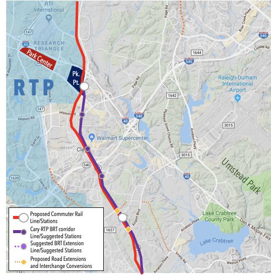
For example, it turns out that the 2045 transit plan by CAMPO (the Raleigh area’s transit planning authority) has an eventual provision for a Cary-RTP BRT service, presumably along NC54. So why not make a spur line out of that?
I came up with these two ideas, which I was only able to pull off with exclusive busways; otherwise, slopes would be too steep and/or existing buildings would get in the way.
Suggestion A:
Branch out of the proposed BRT corridor from the McCrimmon Parkway area.
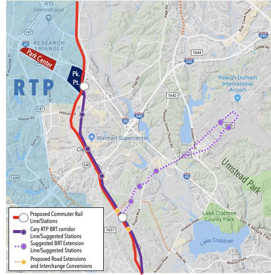
Possible extensions in the distant future: NCSU and downtown Raleigh, via Cary?
Suggestion B:
Make a circulator/mini-route from the proposed urbanized areas of RTP (Park Center and Park Point, f/k/a Triangle MetroCenter or Nortel).
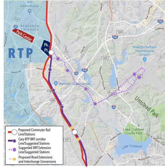
Possible extensions in the distant future: Park Center, Southpoint, and Chapel Hill?
EDIT: I also crunched some numbers (see below for my work), and it looks like construction alone could cost about this much (i.e. this doesn’t include right-of-way purchasing, planning studies etc.):
Suggestion A: $123 million
Suggestion B: $162~$164 million (depending on how you go around the Sheraton)
click me for more details
Don’t worry, I’m not pulling these wishy-washy solutions out of my ass; I tried thinking about the terrain, construction impacts etc. I couldn’t figure out how to make the McCrimmon divergence work (mainly because I couldn’t find any concrete plans about it), but I think you can get away with having reliable operations on a majority of these routes just by converting one lane per direction to be bus-exclusive.
The only exceptions (i.e. need to build new structures) would be for:
- a flyover across Airport Blvd. onto Slater Rd. (suggestion B) or Perimeter Park Dr. (suggestion A)
- weaving through the superblock wedged between I-40, Page Rd., and Miami Blvd. (suggestion B only)
If you want to see how expensive this could be, here are the path lengths converted into dollars using numbers from this guide from the FTA plus this website to account for inflation:
Ballpark cost estimates
$81,000 ($60,000 in 2004 dollars) per pull-out area
$34 million per mile ($20 million per kilometer in 2016 dollars) for building new ground-level BRT path
(I used $20 million per mile for converting existing lanes to BRT-only, and $30 million for new construction)
$100 million per mile to build light rail (using ITDP’s conversion factors; DOLRT was $170M/mi)
$1.4 billion per mile to construct heavy rail (ditto to LRT)
add roughly $20 million per mile for aerial segments (i.e. you’re building a bridge for it)
Compare these numbers to:
$170 million per mile for Durham/Orange light rail (though this includes all the land development ideas GoTriangle packaged onto it)
$18 million per mile for Chapel Hill’s BRT (will mainly convert existing roads’ outer lanes into bus-only lanes)
$20 million per mile for the New Bern segment of Raleigh’s BRT (3-mile segment for $60M)
Segments in Common
4.27mi (6.88km) - convert lanes on Airport Rd. in loop around RDU to/from Aerial Center Pky.
2 ground-level stops (former Morrisville Outlet Mall, two terminals of RDU)
Suggestion A only
0.43mi (0.69km) - convert lanes on Airport Rd. from Aerial Center Pky. to Sorrell Grove Church Rd.
0.37mi (0.60km) - build bypass bridge from Sorrell Grove Church Rd. to Paramount Pky.
0.72mi (1.14km) - convert lanes on Perimeter Park Dr. from Paramount Pkwy. to NC54
3 more ground-level stops (two in Perimeter Park, McCrimmon CRT station)
Suggestion B only
0.33mi (0.54km) - build bypass bridge from Aerial Center Pky. to Copley Pky.
1.23mi (1.98km) - convert lanes on Slater Rd. from Copley Pkwy. to current Regional Transit Center
0.24mi (0.38km) - build bus-only path from Creekstone Dr. to Old Page Rd.
0.27mi (0.44km) - build bus-only lanes on Central Park Dr. from Old Page Rd. to Miami Blvd.
4 more ground-level stops (Carrington Mill Blvd., Sheraton Imperial Hotel, Creekstone Dr., RTP Park Point)
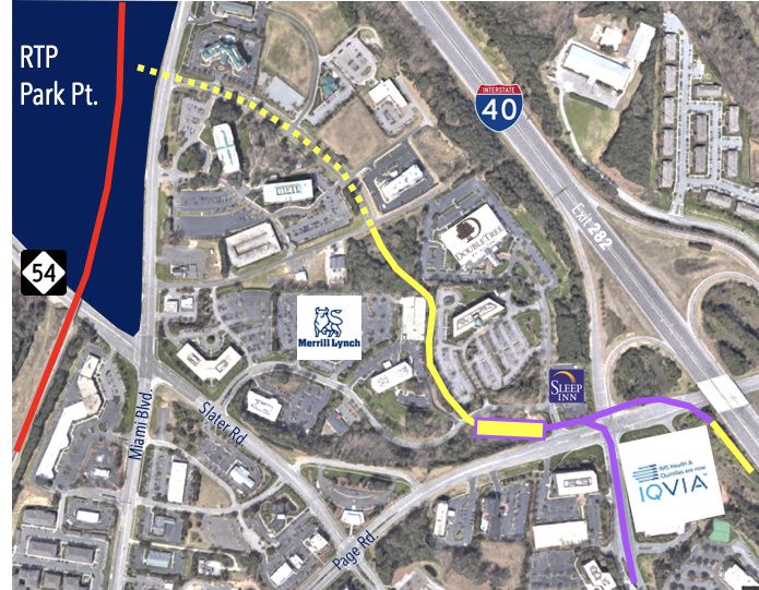
Purple = aerial / yellow = ground; solid lines = construct new path / dotted lines = expand road
Here’s the base map, if you want to make your own: