Yeah I get that it’s infuriating - from the city’s perspective though, they don’t look at individual intersections, they look at signals along corridors and figure out what the best timing is to get someone from one end to the other the most efficiently.
For example, here’s the Wake Forest Road/Falls of Neuse group from Millbrook to Whitaker Mill:
They run all of the signals in between on the same cycle length so that it’s easy to coordinate the timings between the signals - unfortunately there are some major intersections on that corridor (Six Forks, 440 interchange, Millbrook) that require some longer cycle lengths so that’s why Whitaker Mill is also on that 180-200 second cycle length that those signals are on. In the PM they do already run Whitaker Mill on a half cycle of 100 seconds (while the rest of the corridor is 200 seconds)
(and yes as you alluded, while the overall average wait time at the Wake Forest & Whitaker Mill Road intersection is 20-30 seconds, it’s much longer on Whitaker Mill - it’s 15-17 seconds on Wake Forest, 71-77 seconds on Whitaker Mill in the AM with the 180 second cycle length, and around 35 seconds in the PM with the 100 second cycle)
Do the timings run on the schedule off peak hours?
Or does it revert to just changing when they a car is at the sensor. Would seem like overkill to have them timed off peak too since volumes are low at a lot of the cross streets.
I only have the peak hour timing plans from the city but as a resident of the neighborhood, they definitely stop running the schedules at some point late at night to early in the morning. If you’re out and about at Wake Forest & Six Forks at 1 AM, it’s just detector based at that point.
I do not understand why people in Raleigh complain so much about traffic. Guess because can not drive 45mph all the from suburbs into downtown or anywhere else wanting to go. I just always tried to live close to work to avoid traffic. Learn that lesson while working on K street in central DC for a year and living 13 miles away in Greenbelt. Was 2hr drive, or more, each way. Made promise never never do that again. (btw before metro went to Greenbelt). After that all projects in DC I stayed as close as I could or if work site was near a metro stop, stay close to one outside beltway. Raleigh has it great when comes to traffic.
Thank you for taking the time to explain this! I knew intersections on major roads were coordinated (like Capital), but I had no idea they were for other roads. Very interesting! Doesn’t make it any less annoying when you’re waiting for 3 minutes, but at least I know why now!
I’d be surprised that there’s realistically times with no WF traffic…
Guess it’s all relative. Personally, I’m excited about ALL of this new development along Whitaker / Atlantic. Full Stop. Regardless of wait…
Yep! I’m sure there are exceptions but most of the signals within the city are part of a system of some sort and coordinated together (Atlantic Avenue from Brookside to Highwoods, Glenwood from St.Mary’s to Creedmoor etc…) Which is why sometimes you can hit a few signals in a row and ride the green wave.
It’s interesting because I find that when driving on WF road toward downtown, the signals synchronization is terrible. I will almost always get a red at Creekside / Hodges or McNeil. What I mean is that it’s difficult to get successive greens like on Dawson/McDowell for exemple.
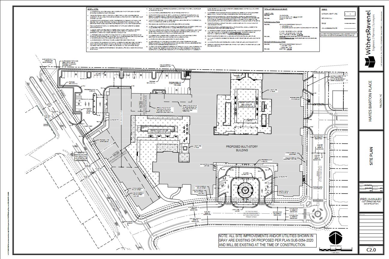
Here is a link to the traffic study for the development: TIA-part1.pdf (1.1 MB)
The Creekside/Hodges signals are horrible and I’m curious if there’s an issue with those signals beyond just bad timing - they’ve malfunctioned several times over the past few years and it seems that the phasing/timing is incredibly inconsistent (sometimes if you’re on the side street you’ll wait forever without getting a phase or other times it’ll call the phase every single cycle even if there’s no cars).
we don’t really do video detection here in NC so it’s all pavement loops. I know I’ve pulled up some signal plans in that area before in the past (not specifically those two intersections though) and there are some detectors that they don’t even know the location of and the plans are super outdated
“If you go and interrupt that comprehensive plan, then you end up in a situation where someone’s building Six Flags in your backyard. It’s just not appropriate,” said Carmichael.
Kind of sad. They took two people that complained at every public meeting, well done.
I recently talked to several neighbors who live right next to the development (it’s literally happening in their backyard) and people are generally for the rezoning because it’s seen as an improvement over the existing situation and it will bring new amenities close by.
This lady has been approached by the five points CAC (at least what’s left of it - it gravitates not far from livable raleigh and it’s leaders -) and has been named the referral person for this project for the neighbors. It’s such a joke.
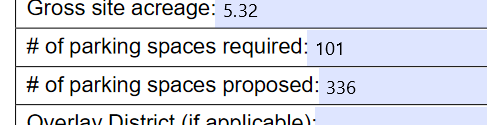
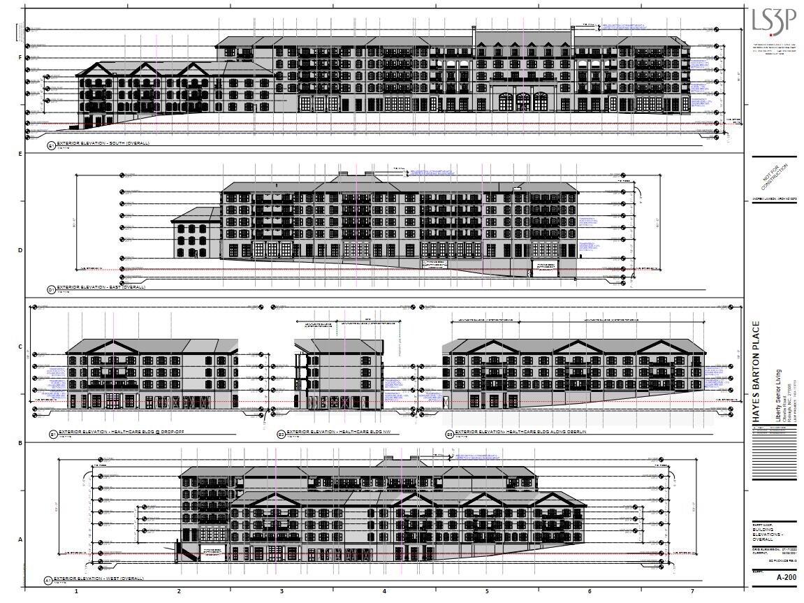
Administrative Site Review for “Hayes Barton Place” senior living just popped up on the Wire and it appears to be 91 units. 3-5 story building, 587,640 sq. ft. Developer is “Liberty Senior Living.”
Something doesn’t add up with that square footage, unit count, and parking space count.
Typical parking structures have 350 square feet per space. 350*336 = 117600.
587,640 gross sqft - 117600 = 470040 sqft left over
470,040 / 91 = 5165 sq ft per unit. Which is bonkers. I understand these sort of places have support facilities and community/activity spaces and such, but that just seems like a really huge facility for such a small number of residents.
There must be some other use planned that doesn’t count as a typical “dwelling unit”. Maybe 91 units is the number of independent living apartments, but long term care or skilled nursing units don’t count towards the number of dwelling units.