It’s not very clear where updates for Midtown Exchange (and Midtown/North Hills projects aside for those with specific threads) should go, so here we are:
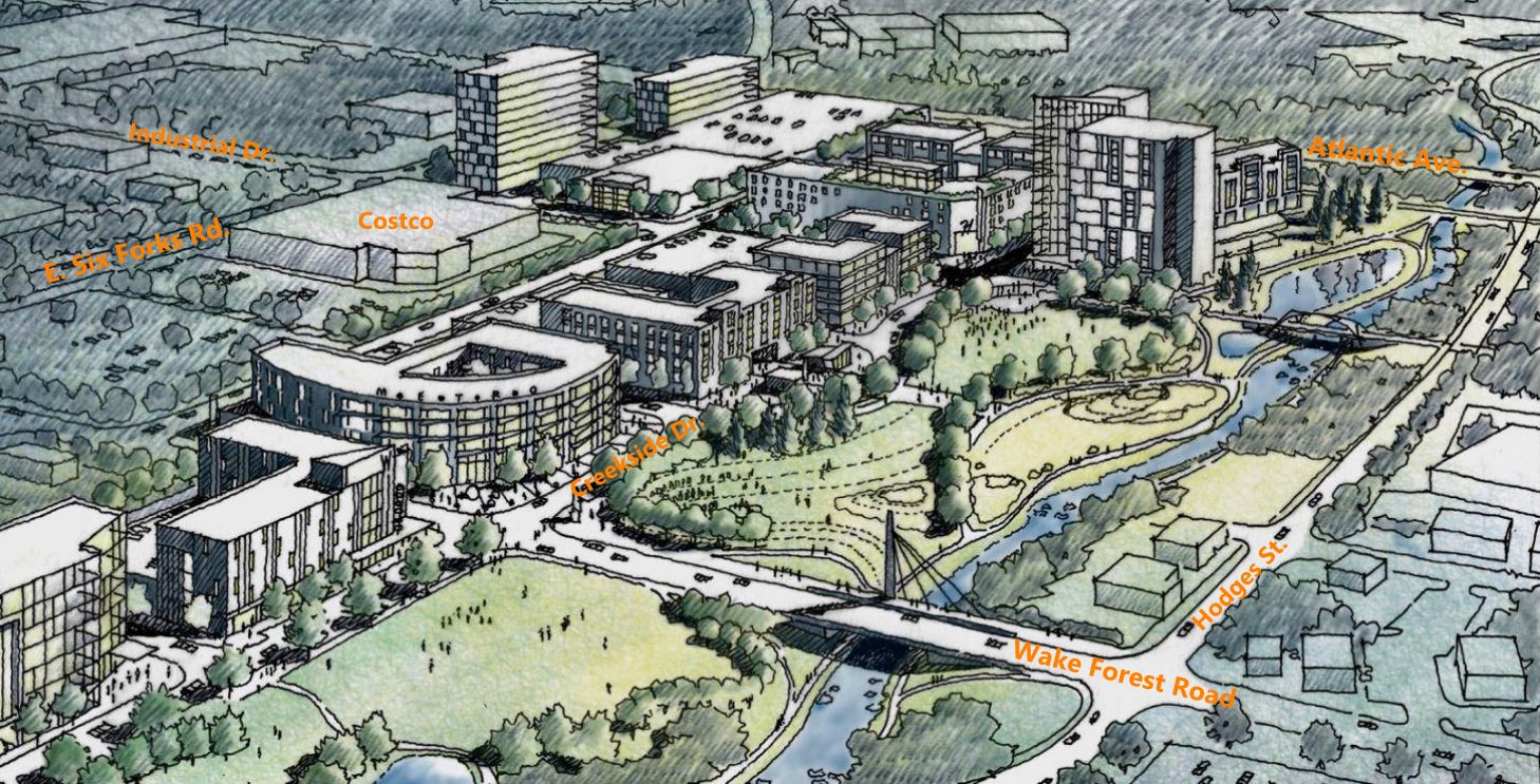
Dewitt Carolinas released more details about their planned flagship building for Midtown Exchange -the mixed use project coming up across Wake Forest Rd. from Duke Raleigh Hospitals.
For those of y’all who forgot, this is the plan that’s aiming to bring a waterfront park along Crabtree Creek as well as lots of walkable developments between Capital Blvd. and North Hills. Or as @mike pointed out in his post, this thing:
The City currently owns the triangular wedge of land to the north, but will trade it with York Family Properties for the land to the south. They both turn out to be worth $37k since the larger parcel is in a flood zone (blue).
I’m expecting this or better in regards to building designs and height. By the time this is completed Raleigh will have 3 big parks and a much larger greenway system and I’m excited.
Regardless of not landing HQ2, Raleigh’s prime corridor is well under way with both the announcements to pull midtown toward downtown, and with downtown south pulling downtown toward Garner.
Speaking of Altanta, I’d love to see this stretch of the greenway start to resemble Atlanta’s Beltline, and this could be the first piece of the puzzle for greenway facing development. The Beltline is used for recreation, transportation, Beltline facing major retail, office, housing.
Of course the Crabtree greenway will never fully resemble the Beltline, but it can’t hurt to start dense developments along this stretch to see if and how it will take off. Worse case scenario is removing light industrial sites and car dealerships to build dense housing and park space in the worst flood zones. Best case would be if the live, work, play developments succeed and this triggers similar developments along the Crabtree and the future offshoot leading to north Hills and Pidgeon Branch going into Downtown.
I’ve said it here before, that in today’s age of red tape and vocal minority community backlash, the path of least resistance to succeed in outside the box and transformable development/redevelopment is the best way to actual get great things done. And this area is the perfect place to start, in terms of the least backlash and least resistance. It also can offer a continuous urban environment from North Hills to Downtown if things are done right in the next 10-30 years. North Hills down Six Forks and along St Albans/Highwoods Boulevard to Capital. Capital Pidgeon Branch Greenway into Downtown. This type of development can also go down Wake Forest and Whitaker Mill over to connect with Five Points. It actually forms a pretty large and congruous area with minimal SFH disruption.
We should temper our expectations for a great pedestrian / retail environment along Creekside Drive. That is still floodplain. It probably floods every decade or so at least. It’s not impossible to build retail ground floors in these conditions but nobody builds Crabtree Valley Malls anymore: you won’t usually see it where there is not already a significant historical district there to create a critical mass (see: Biltmore Village in Asheville.) Even then it significantly impacts the way property is developed.
Expect most things here to be built with the ground floor at a level raised out of the flood plain, by either trucking in fill dirt or building only parking at ground level.
Would be super expensive, But really cool if they built a dyke system so development could abut the floodplain safely.
My father knew a guy that at one point was assembling/planning for a radical waterfront development along Crabtree Creek utilizing the quarry on Duraleigh road as flood control to keep the Creek at a constant level downstream in DT. Look at how close the creek comes to this quarry! it wouldn’t be hard to imagine a system that diverts excess flood water into the quarry to keep downstream development from flooding.
I once did the math based on flow volume from historic floods and lidar data to estimate the size of the quarry. While the quarry could significantly attenuate flooding in many cases, it doesn’t seem like it is large enough to contain the worst of the historical flooding incidents.
I am not a stormwater engineer and my calculations were extremely rough, though. Basically draw an area polygon on IMAPS and multiply by LIDAR depth (creek bed elevation minus the elevation of the bottom of the quarry) to get the volume; then the definite integral of (total flow minus flood stage flow) over the course of the event at the measuring station closest to Crabtree Valley mall. My estimated excess flow volume for one of the hurricanes (Fran?) was more than my estimate of the capacity of the quarry by a pretty significant margin, can’t recall exactly how much. Like 50 or 100%.
Seems totally logical that the quarry would not abate the worst of the worst event, but could significantly help the average brush with a hurricane that floods Wake Forest Rd. Area.
Seems to me it floods to some extent almost every year? I guess it’s a matter of degree but it seems like at least the area around the dealerships floods pretty regularly.
Yea, Hodges Rd., Atlantic and Wake Forest Rd. flood every year, it’s been a while since the flood waters made their way to Creekside. But I would be very gun shy to build anything ground level anywhere in this area. Really anything besides a multi-level parking garage facing the creek would be stupid.
Even the small car dealership at the bottom of Wake Forest Rd grew tired of constantly moving their inventory each time it rained and Pigeon House would flood so they relocated.
Buildings in flood zones with parking on the bottom level are pretty common, as are buildings on fill withthe ground floor lifted out of the flood plain.What is not common is new construction with anything more than a lobby on the ground level in a flood zone. Flood-proofing habitable space is expensive, restricts what materials and finishes can be used (no drywall!) and limits the uses that make sense (don’t want a kitchen down there, or really any equipment that can’t be easily moved).
Even better, why not just put parking on the ground level and raise the pedestrian experience up on a boardwalk type experience above it? In a way, North Hills did this very thing with their parking “underground”. The boardwalk could overlook the new parkland, and visitors to the park could just use the lower level parking for easy access to it if they are coming by car.