Raleigh-area Mall / RTP Redevelopments

I’ve been thinking a lot about this since the Six Forks road plan was reconsidered. I grew up in North Hills in the 80s-90s. I don’t live there anymore, but I go through there 3-4 times per week. Is the traffic really that bad? Yes, there is congestion, but it’s rarely more than a few minute delay.

I’d be more concerned about the danger to pedestrians than an increase in commute times for area residents.

11 Likes

The mall traffic is seasonal, and very heavy around christmas holiday shopping. But the main issues are when you continue north on Six Forks heading towards Millbrook and vise versa. Lots of congestion north and south of Millbrook.

2 Likes

Six Forks and FoN are both N-S commuter throughfares. There’s choke points all along their routes, including but not exclusive to NHills…More change is coming and Helfant and crew need to accept that its better to densify and have walkable options nearby so you don’t need the car for everything, 'cause more people just keep coming…

5 Likes

Yes, I’ve had to wait more than one light cycle trying to turn right onto Six Forks from Millbrook. But that’s not necessarily a symptom of North Hills growth, but of an entire city that’s growing.

5 Likes

Change is coming yes, but not 1 single person is going to walk to these developments from North Hills. I used to make this trek often from North Hills and the bridge sidewalk crossing 440 basically doesn’t exist. I was clipped by someone’s mirror once walking home with groceries, and I never did it again, and never will.

Much has been made of the idea of a pedestrian bridge across Six Forks between North Hills and NHE. I have made much of how much I hate this idea: it’s a stupid project that doesn’t match the topography, that nobody will use. If you’re going to do it, build a tunnel! Otherwise, don’t bother.

However, I would be highly supportive of the idea of a pedestrian bridge, or bridges, over the beltline. This would deliver far more bang for the (inevitably, public) buck than a pointless bridge over Six Forks.

This matches the topography well, so there would need to be little in the way of stairs or ramps to ascend up to the bridge.

It adds 400-500’ of distance, compared with using the pathetic sidewalks - but little in the way of climbing or descending, so it would be much more likely to be used than a Six Forks bridge.

And it solves the far more pressing issue of pedestrian safety crossing the Six Forks-Beltline interchange.

The bridges themselves would be shorter than the one at the Art Museum (~600 feet long; $3.8 million in 2005), but longer than the one on the Tobacco Trail at Southpoint (~300 feet long; $7.4 million in 2014)

24 Likes

I just want to clarify for the record this person is not associated with me or @GucciLittlePenguin

3 Likes

You can smell there disgust.

So no relation to the Hoochy Gucci girl. Got it.

1 Like

You’ve learned the secret. Build density where everything isn’t accessed by a car and the traffic mitigates itself. The reason the traffic is bad in NH is that most folks who go there come by car.

1 Like

honest question…why build elaborate pedestrian bridges over 440. There’s already an existing sidewalk along Six Forks over the bridge across 440. Seems the only issues are crossing the entrance/exit ramps in the existing crosswalks. I don’t go thru this intersection more than once or twice a year so I don’t know the answer, but can’t they just improve protection for pedestrians with what they already have built? …rather than a build a taj mahal walkway/bridge thing that as pointed out, will be much longer of a walk.

The new bridge would be wide enough to accommodate both bikes and pedestrians. It is not good to have both bikes and pedestrians share a 5 ft path. This could be accomplished if we removed the 3rd lane from Six Forks Rd (good luck) and put in a multi-use path instead to accommodate both bikes and pedestrians.

The on & off ramps from 440 East should also be changed (both south and north). It should be brought to Six Forks light with a much sharper turn to prevent cars from simply rolling through since they don’t already (which is seen at numerous pedestrian crossing sections across the city). With the existing configuration, cars move too fast around the corner and do not yield to pedestrians attempting to cross.

It doesn’t need to be a very extravagant bridge. I actually hate when art gets tied to pedestrian/bike projects. I enjoy the art, but it does tend to inflate the cost and delay construction. I’d say build first and the put the art installations separately as part of different funding.

As far as distance, it actually may shorten the distance for users. On the west side, have an entrance at the Target parking lot. On the East Side, have a connection into North Hills East. Pedestrians won’t necessarily need to go all the way to Front at N. Hills St.

I would still like more prioritization on the crossing between NH East and West. Pedestrian wise, the crossing is ok, but biking wise I don’t care for it as much. I would like a bit more space so bikes can filter through (or bike lanes is ok). Currently I’ve done a mix of street and then crossing at the crosswalk on the bike. It depends on how heavy traffic is.

1 Like

If you can convince NCDOT and the City of Raleigh to give up the high speed ramps + a lane or two across the bridge to increase the sidewalks to a satisfactory width, install barriers, and tighten up the curb radii to reduce speeds and make crossing distances shorter -then maybe. Even then pedestrians still have to contend with on/offramp traffic.

So, as you know, all those changes basically decrease the traffic handling capacity of the interchange. Great! Less traffic, right?!

Not exactly. While doing road diets and such on arterials (sacrificing capacity in order to allocate road width to other purposes) is fantastic, and is sometimes done even at the expense of congestion (Hi, Hillsborough Street!) - it is considered a cardinal sin of traffic engineering to have a freeway offramp where queues back up past the end of the ramp onto the highway. So you’d have to be absolutely sure that whatever changes are made, don’t wind up doing that.

Also, look at what they’re doing at Blue Ridge Road. Where removing traffic lanes is not possible, it turns out it’s simpler to add an extra, dedicated bridge for bike/ped instead of widening the existing bridge to add proper bike/ped facilities. And turns out those dedicated bridges provide an overwhelmingly superior experience for pedestrians.

I would also dispute whether the “detour” notion holds water at all.

For example, somebody walking from the intersection of Six Forks & Computer Drive to Harris Teeter at NHE, the distance is actually the same. Or from Six Forks & Ramblewood to Target, it’s quite a bit shorter to use the bridge route. Basically, it’s the same distance or less if a pedestrian’s destination is within North Hills. It’s only a detour if their destination is further down Six Forks. And let’s be honest, North Hills is the overwhelmingly likely destination for any pedestrians who might be walking across the Beltline.

Also, it turns out that building dedicated, grade-separated bike/ped pathways through high-traffic, high-conflict intersections and interchanges is actually pretty common even in places like Denmark or the Netherlands. It is a misconception of American urbanists that everywhere in Netherlands is a slow-traffic, single-lane, bike-first paradise. Yes, even they have freeways and high-traffic, high-conflict areas. Check out a map of NL. Freeways, high speed roundabouts, and free-flowing ramps are EVERYWHERE.

The difference is, in their case they mostly build in the safe, protected routes for bikes and peds from the start, rather than retrofit after the fact as we’re forced to do. But I’m pretty sure an engineer from the Netherlands wouldn’t look at an interchange between a highway like the beltline and an arterial like Six Forks and think “Let’s make it look like downtown Utrecht” - they would just put in a separate bridge.

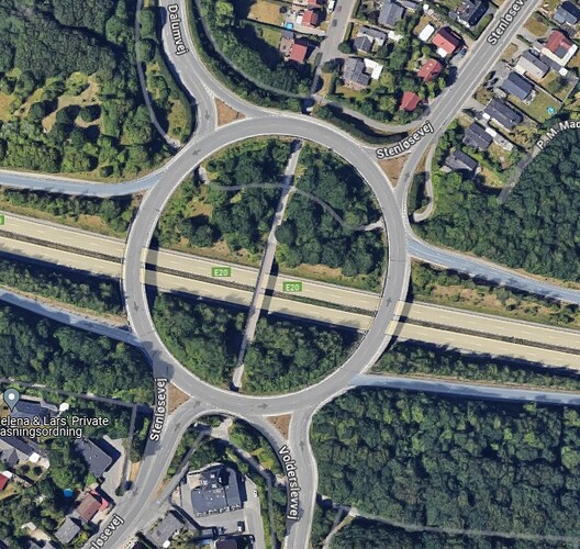
12 Likes

OMG are those SFH homes, in the Netherlands?

Shame!

In all seriousness, can you link to that location? That’s an awful lot of gorgeous engineering to be wedged between two low density residential areas

That image happens to be from Odense, Denmark. Perhaps that type of housing is less common in NL (it does exist, though!), but you still don’t have to look far before you find examples of separate facilities being given to bikes/peds in high traffic areas

1 Like

I know that. I’m an alumnus of the same program.

To make that interchange more pedestrian friendly, is it possible to convert that interchange to a tight SPUI (like the one on I-73) at Friendly Ave? The advantages of it is that there’s only one set of signals so that means traffic will be able to move faster without stopping twice compared to the other interchanges that need two sets of signals. Diverging diamond I would be against because those are more designed for traffic that opts to get on and off the highway. What do you guys think of the interchange getting rebuilt? I feel like it will have to some day as that bridge was built in the 1960s and it could be nearing the end of its lifespan. This will reduce the overall footprint and like open more space for development. Obviously this will be expensive due to the fact that you will have to build tons of retaining walls, but that’s appropriate for a project like this in the North Hills and Midtown district.

Also to add, if Six Forks Rd widening is not going to happen, then will they possible extend BRT along that corridor to Six Forks Station Shopping Center? I mean there’s not really much there so BRT doesn’t really have a place there IMO, just my thoughts. Some people said they should make it more pedestrian friendly and others have voted for sticking with the original project of widening the road to 6 lanes. But when reviewing the votes on the website, it appears most favor canceling the project altogether and then trying again in the future.

I could have sworn that you were wrong and the bridge dated to 1993 when the northern Beltline was widened and rebuilt, but I looked it up and you are right - the bridge was built in 1961. (Lassiter Mill’s bridge was built in 1993, though.) While that age doesn’t necessarily imply structural problems, I do agree there is a good chance it will need to be replaced before long.

So, if the idea is that there will be a second skyscraper district south of the Beltline along Computer Drive, then it’s essential to have a better pedestrian connection.

DDIs, SPUIs, Parclo A, Parclo B (the current interchange is one of these)… all of these are inherrently crap for pedestrians.

Plain diamonds are ok as long as there are no free-flowing connections, because all the intersections are signalized and right angled. But both sides of the arterial still require pedestrians to cross two ramps.

The only type of interchange that is truly pedestrian friendly is a folded diamond with both sets of ramps on one side of the arterial:
image
I consider this pedestrian friendly because at least one side of the arterial has zero crossings with highway ramps, and the other only has right-angle intersections to cross. But that’s not going to be possible here.

If they could/would get rid of the high speed ramps, yielding an offset folded diamond as below, that would leave only one right-angled, signalized spot on each side of Six Forks where pedestrians would have to cross freeway ramps. This certainly would not help with traffic flow, but it might not absolutely wreck things either. The 440 East to southbound Six Forks is 5500 AADT which is fairly busy but probably could work. The busier of the two ramps, 440 West to northbound Six Forks, has 9500 AADT, which strikes me as quite a lot, given that it would be converted from a free-flowing movement to a signalized left turn. If they can make it work, with double or triple left turn lanes and a dedicated straight-through lane (or two?) into NHE, then by all means please do! But I am not especially optimistic about the chances. We don’t want cars backing up onto the beltline.

Therefore I conclude that probably the only practical way to have a crossing that actually feels safe for pedestrians given the volumes of vehicles passing through this interchange is separate bridges for foot and bike traffic. At that point, SPUI, DDI, whatever - I don’t care - pedestrians don’t mix with traffic so it’s all good.

4 Likes

Seems like a great idea. It could mediate traffic flow, that means less finder binders too.

Took a ride over to North Hills yesterday. I locked my bike to a bench and was able to go take a quick look at the Bal Harbour shops. My main purpose was to stop at Total Wine. I was happy to see Total Wine now has a bike rack right in front. It was very easy parking for me on Christmas Eve. I haven’t been to Total Wine much since I’ve been going to breweries as of late.

Back to Bal Harbour: I think I’ve made a mention on a previous post that the shops being on the far side of the parking lot was a bit of a letdown for me. It would have been better if it was incorporated into the existing North Hills shopping area or at least on the closer parking spots to the Main District. The exterior utilities could have faced outwards instead of towards the main shopping area.

If you arrived by car, the parking lot is very limited so you do have the potential to walk a bit :scream:. I believe the garage across Six Forks is closer than the Target in the garage. For me, it’s not a big deal, but if you’re catering to a high end clientele, I would have expected a bit more convenience :violin:.

The reviews overall on Google are not great. I guess they make you download an app to get it. I simply walked up. I saw people at the entrance, but just went right in.

Aside from it being isolated, I think the shops do show how “easy” it is to set up a nice shopping environment for people to browse or eat. Some nice decorations, no cars rolling through the center, some trees, and a few shops. I like that it shows that additional shopping areas could be implemented in places where it may be currently lacking. For example, this could work well at City Plaza downtown.

Bonus photos from North Hills:

22 Likes