it was a walkway around the twenty something floor of Buffalo city hall…it was cool
1 Like
similar note, i would go to the school for the blind in raleigh (gov morehead) alumni reunion and hear central prisons lockdown horn in june. 40 plus yeaqrs ago.
I still like the Gondola idea from Dix Park to near the convention center.
9 Likes
Well, I guess you thought you’d heard the last of the fountain/statue idea. I still believe it could be an Iconic landmark, and attraction for the City of Oaks. I’m still certain the location I suggested would be the ideal spot! The few who commented on it didn’t seem to take the idea seriously. So, I’m back to “rekindle the vision”. That spot where Hillsborough and Edenton merge is an area of both vehicle and pedestrian traffic. It’s also somewhat in the middle of Downtown! Everyone can take advantage of the opportunity to view, and gather together at an easily accessible location! The potential for organized events would be enormous! Just sayin’…
5 Likes
I just don’t see a “fountain” as being an “attraction” that people would come visit. Iconic landmark, sure. Maybe. But a fountain is not an attraction IMO. It’s not bringing tourism, in other words.
1 Like
Maybe we can buy the Trevi Fountain and take it off Rome’s hands. They have enough old stuff.
5 Likes

Since no one seems to want to do one in Charlotte, how about a big ferris wheel where you could see downtown maybe in Dix Park. By the way I am in your metro area tonight and tomorrow be aware.
10 Likes
I’d be into that idea. Light it up red when the Canes win too.
11 Likes
I want a similar idea to this but set in the range of big hills to our west. It would be cool to have backpacking trail crossing the range with observation towers on 3 major peaks. “The Shakori Traverse Trail”.
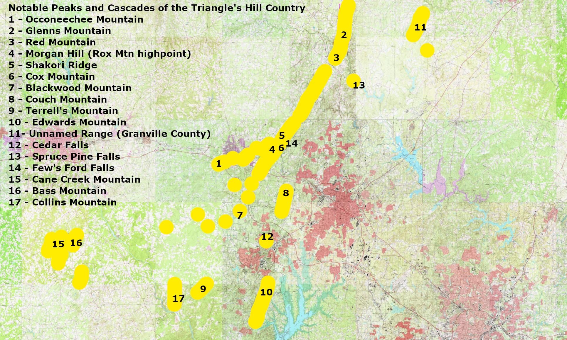
I think Couch Mountain, Morgan Hill(or another peak in Eno River State Park), Occoneechee Mountain, Glenns Mountain, and the Granville County High Point are great spots for a view of both downtowns of our region.
Couch is a bit short but is so much closer to the cities it has a better view.

The spectacular view of DT Durham from Couch Mountain. Raleigh would also be visible on a clear day.
This is would rebrand the regions reputation for natural scenery. We’re not just in a boring part of NC 2-4 hours from the mountains and the beach. We have actual scenery here. Just need to utilize it better.
7 Likes
I was playing around with a topographical map the other day and was surprised to learn that Durham doesn’t really sit higher than Raleigh in elevation. I expected them to be a 100 feet higher than Raleigh. That said, the Piedmont rises more just west of Durham more significantly than Cary rises west of Raleigh.
4 Likes
Yup Durham sits in a Triassic Basin–A big canyon that filled with sediment with only the last few hundred feet of the rim exposed. That wall is still visible from anywhere in town if you get above the trees.
My home in Durham is at a lower elevation than most of Raleigh–only 270 feet.
4 Likes
That is so surprising to me! Thanks for the additional information on it. 
1 Like
The real elevation change happens just west of Durham which you can see going up the big hill on I40 between 15/501 and NC 86.
3 Likes
Lowest elevation in Raleigh is along Crabtree Creek and the Neuse River near Anderson Point, about 162 feet. There are patches about 520 feet in the northwest (Leesvlle Rd and 540). Also a hill at 510 feet along Hillsborough St near the Western Blvd junction. The ground outside Dorton Arena is 500 feet.
5 Likes
3 Likes
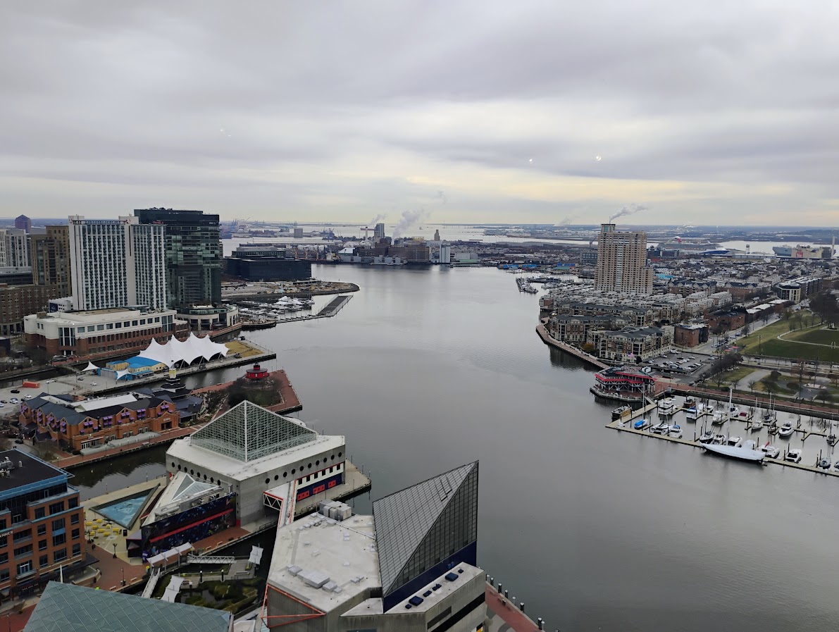
Inner Harbor! 
4 Likes
With Dix Park around the corner from Pullen Park and Dix being a new family destination play area, could more rides and attractions be added to Pullen? Along the same vein of the original Elitch Gardens in Denver…Pullen could have the existing 3-4 kiddie rides but add a few more compact rides of a bit more thrillling nature, or just more of a smallish kids-oriented amusement park, just with more age range of rides than is now there.
If I’m going for a family picnic with kids, there’s now a lot more to offer for that kind of experience at Dix (minus the few rides and the lake), which to me means it wouldn’t be taking much away from the Pullen experience adding things there, since Dix is so close to it for more play and explore and picnic vibe.
8 Likes
I hope that, perhaps with the Ashe Ave realignment, the entrance to Pullen Park gets reworked. It feels very suburban; big surface parking lot with tiny sidewalk access.
4 Likes
Roads that sit on notable ridgelines:
- Blue Ridge Road (duh) from Hillsborough to Edwards Mill Rd
- also duh, Ridge Road from Meredith north to Glen Eden-ish – fun fact, Campbell Library at Meredith is the highest point ITB, at 472’
- Six Forks-Sandy Forks-Falls, from North Hills up to well, the river
- Strickland Road – I guess this is why it was always the break separating large-lot houses in the Falls Lake watershed vs. conventional North Raleigh sprawl in the Crabtree Creek watershed
- Hillsborough, from Oberlin to downtown Cary
- Kildaire Farm Road and Walnut Street from downtown Cary to US 1/64
- Ten-Ten Road from Apex past Holly Springs Road
Leesville itself looks like it’s the highest point in town. And I guess I’m a bit surprised how much higher “Westover” (an old name for the Fairgrounds area) is relative to the rest of Raleigh.
2 Likes