Got pulled into some really cool commentary on the Marbles parking lot 30 Story Rezoning thread about some of the legacy Raleigh roads, the routes they followed originally and how they evolved to what we know now. As I understand it, many of the main arteries (especially on the north side of the city) such as Millbrook, Six Forks, Lead Mine, etc went through some pretty drastic changes over the years before coming to their current alignments. Thought it would be cool to start a thread to discuss the roads, maybe share old maps, etc, and also talk about improvements you’d like to see to some of the current roads.
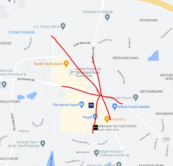
One thing I’ve always wondered is where the name Six Forks came from. Me and @Christopher think it stems from the intersection at Strickland Rd, as both Baileywick and Old Lead Mine used to terminate just outside of that intersection which would have been six roads, or “six forks”. However, I suspect that Strickland originally followed what is now Baileywick, and if that is true then there would have originally only been five roads at that intersection. Another theory I have is that Six Forks might have originally run along what is now Anderson Dr, and the intersection with Glenwood and St Mary’s and another neighborhood road would have created six forks. I cannot find a map old enough to confirm this though. Does anyone have any knowledge about this?
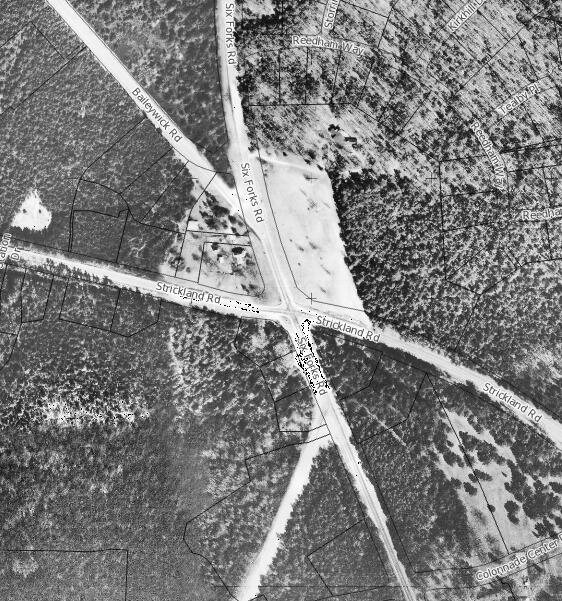
I had an old aerial of of the original intersection of Six Forks/Strickland/Baileywick/(Old)Lead Mine Roads but can’t put my hands on it just now… it was something like sketched.
Lead Mine Road was realigned to the west and Baileywick was cut short as well as the city grew outwards.
This is close to where I live, and I had the same question about the origin of the name.
Another road I have always wondered about is Rock Quarry Rd. First, was there ever a quarry anywhere? I don’t see evidence of one other than the still functional Martin Marietta quarry on Garner Rd next to I-40, and that seems to far away from Rock Quarry Rd to be it.
Second question is, did NC 50 ever run along part of Rock Quarry Rd? Looking at how 50 goes through Garner, it appears that it may have originally followed New Rand Rd from near the Timber Dr intersection, then veered to the left onto Rand Mill Rd, which would have crossed the train tracks and turned into Creech Rd. Creech Rd turns into Sanderford Rd, and Sanderford ends at Rock Quarry but if you drive past that intersection, it looks like Sanderford may have originally continued due north onto what is now Rock Quarry, over I-40, and into the east side of downtown Raleigh.
Apparently so, and it was used to help build the capitol. I remember a discussion on the subject awhile back where someone pinpointed the exact location: General Raleigh History - #263 by dtraleigh
I watched some of the September 3rd council discussion. at approximately the 1 hour 20-minute point six forks density and traffic was discussed… Without some crazily expensive redo of Six Forks Road, is the only thing that can be hoped for for traffic flow improvement, with more density on the way, is maybe some tweak for the beltline for cars? Is widening not an option with all the businesses on the road? Maybe better sidewalks by widening them for limited multiuse and just cyclists and pedestrians using the ‘better painted’ crosswalks? unless you dump a lot of transit on the road, what will change?
There’s gonna be no good solution. The stretch between the I-440 interchange and Millbrook has too many intersections and entry/exit points for it to accommodate smooth flowing traffic. While it might not be a classic stroad, it definitely suffers from many of the same problems.
At the intersections with North Hills shopping center and Lassiter Mill, separated pedestrian crossings (tunnels or bridges) would both increase pedestrian safety and cut down on the wait time on the light cycle. The intersection with Rowan St. is probably not needed and could be eliminated.
I’m partial to the idea of upgrading the sidewalk to a multimodal path to at least got some drivers off the road, but to be honest, most of the traffic is coming from the greater north Raleigh areas.
Really crazy idea: I could see a small scale monorail, like WVU’s PRT, with frequent point-to-point service between North Hills and “Midtown-East” doing fairly well. Buses have a stigma here in America and while trams are sexy, they’re expensive, large, and hard to retrofit onto existing infrastructure.
Give six forks a road diet. Median separated, 2 lanes each direction. Continue to density the corridor and spread density into the surrounding neighborhoods with easier missing middle regulation. Let the chips land how they may. Let’s build cities again
That is a crazy idea because almost no one in the city except a few people on here would support it. Taking an area with heavy traffic and intentionally making it worse isn’t going to be supported by the elected officials who would need to make it happen. I suspect you know this, though.
Clearly you must not have kids that go to Carroll Middle… Been there done that, have another one on the way to Carroll in two more years. The way parents are routed through Carroll and back out, Rowan takes all the traffic. If the bus didn’t come at 6AM, perhaps my kids would ride the bus instead.
It’s not so crazy. I drive this stretch almost every school day dropping of my daughter at Sanderson in the morning. The traffic is heavy, but aside from the spot right by North Hills, but it’s really not that bad.
Would love to see the 6-lane stroad plans revised to 2 (wider) lanes each direction, with a nice median and separated bike / pedestrian paths.
Yep - Also there is St Timothy’s school on the other corner. and a fire station on the 3rd corner of that intersection. That one is not getting closed down.
I agree that the multiple narrow lanes is awful. This would only work if they’d intelligently synch up the lights. No matter where I’m going on that stretch, I get stuck at multiple lights, which is part of why the traffic is a nightmare. It doesn’t need to be a freeway, just have the cars keep moving through at a reasonable speed.
Part of my muahah crazy plan would be converting the intersections to roundabouts.
slow traffic with road diet, which in turn makes pedestrian crossings safer and more pleasant
use roundabouts for local access (like Hillsborough street) which allows traffic to keep moving with shorter stops.
discourage thru trips and divert those trips to other N-S corridors, like Wake Forest and Capital.
There would be winners and losers in this scenario. Wake Forest Rd., Creedmoor rds would be losers. But we’ve already decided that Six Forks is the place we’re building a mini city, so let’s act like it.
I love roundabouts and wish we had more. However, the problem I have with them around here is that only a small percentage of drivers seem to understand how they work. It seems like the smaller roads that enpty onto the larger, main street seem to get backed up. Take the roundabout at Dixie Rd and Hillsborough St for example. I would guess that 75% of the cars on Hillsborough St don’t yield when approaching the roundabout. They see there aren’t any cars in the roundabout and proceed into the roundabout, without any hesitation. If each car would actually yield before entering the roundabouts the flow would be so much better.