Politics. The Piedmont Crescent is the majority of the state’s population, but if you remove the Triad and limit yourself to Charlotte and the Triangle, you’re down to less than half
I think there is a lot of untapped potential for ridership on the NCRR involving intermediate destinations other than just Raleigh and Charlotte, or even Greensboro
Build ridership base. A 2 hour Raleigh-Charlotte trip is not as compelling as 1 hour, but it is still quite compelling
Feasible to build incrementally. Don’t need to find $10+ billion all at once.
helps to grow a substantial local rail contracting industry. If we have two or three local contractors with experience upgrading segments of the NCRR for 125mph with electrification, then we will have two or three experienced local contractors likely to bid on the super high speed line.
Build institutional capacity. Trying to bootstrap from nothing straight to a 200+ mph line will wind up in a debacle comparable to California where the contractors are able to take the state to the cleaners over and over again. Staffing up the NCDOT rail division to have the capability to manage and execute a project like this will take time and experience.
Raleigh-Charlotte direct should happen anyway for the benefit of out-of-staters. Knocking an hour off the trip from Atlanta to DC has wide ranging impacts for the whole eastern corridor.
Which is precisely why it won’t happen anytime soon.
Maybe France would have done it, but their rail system is run nationwide from Paris. Our rail system, such as it is, isn’t really run by any one authority – but any upgrades are done by states, maybe with federal funds. And the political coalition just isn’t there for a super-express line that primarily benefits out-of-state riders, especially when the state already owns the NCRR corridor.
Note that the study which suggested a greenfield route through SC, bypassing most of Greenville and Spartanburg, was done by… Georgia DOT.
First to note in the “State Rail Projects Across North Carolina” section is that we should also be getting the Raleigh-Wilmington study released this year, and the Raleigh-Greenville study next year!
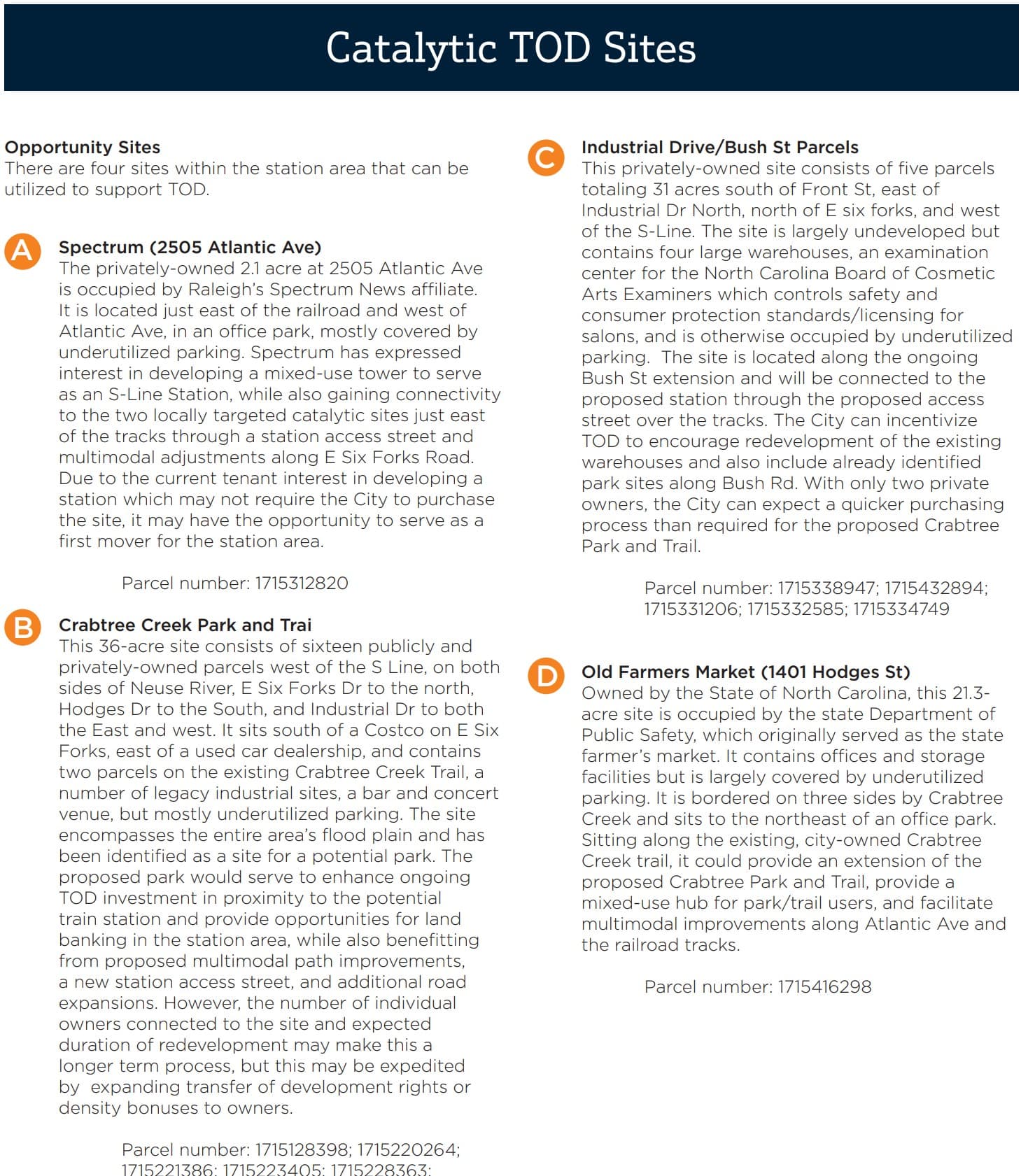
As for the meat of this report, it basically goes through all S-Line communities and analyzes (1) TOD readiness and (2) a TOD vision/preliminary plan.
Note that this is a distinct effort from the Mobility Hub plan, which is also happening for some of the station areas.
Some miscellaneous information to start:
Interesting map of population density along the S-Line
Study is very clear in that this is the marquee TOD area along the S-Line
Has the intended route changed through downtown? It shows the S-Line go across West St. & Harrington St. and then up, instead of following parallel up West St. (maybe the Moxy won this battle?)
Not only are there numerous other S-Line communities I left off here, but this is but a small sample of the detail & descriptiveness of the individual plans for these communities. I haven’t looked through all the Raleigh ones yet, so when I do, I’ll post anything interesting I see. But I highly recommend checking out this document for yourself.
TL;DR: The S-Line is going to be awesome, do a great job at inter-city and regional rail, and it alone is going to incentivize, like, 15k new transit-oriented housing units over the next 20 years, along with a plethora of multi-modal infrastructure.
Kinda doesn’t give me much confidence that these are anything other than pretty picture pipe dreams if they aren’t even going to include the projects already built or proposed. Like sure you could do this if you bulldoze 200 acres but why not show actual targeted goals that could be incorporated into the district??
In the report there is significantly more detail about how to achieve the land-use imagined in these images. Just didn’t have the time/space to include it all. But there are some very concrete action items for the city and state to start working with.
For example, the Midtown area was probably one of the least “descriptive” because so much of what the State wants here has already been detailed in the Walkable Midtown/Waterfront Park plan, but there’s still more than just some pretty pictures.
As someone who lives out in the Apex area, I would love for a high speed rail station to be built here. The downtown area is getting more and more built out and I think a transit-oriented residential development would be perfect. However in my mind I’m just seeing CSX not playing ball by moving their active maintenance yard to somewhere else…Hopefully I am wrong here
I think this is all awesome if it happens but I’m always confused about the intent. Is it really high-speed rail if there are 8 stations through the region? Or will there be high-speed express trains separate from ones that stop more frequently?
Whoever was in charge of quality control for the document visuals was definitely checked out that day. Not only did they put the wrong map for Spring Forest, there’s few other ones:
This picture of a Tri-Rail station, which is a service in South Florida, is cited as Raleigh. The station sign even says "Hollywood"
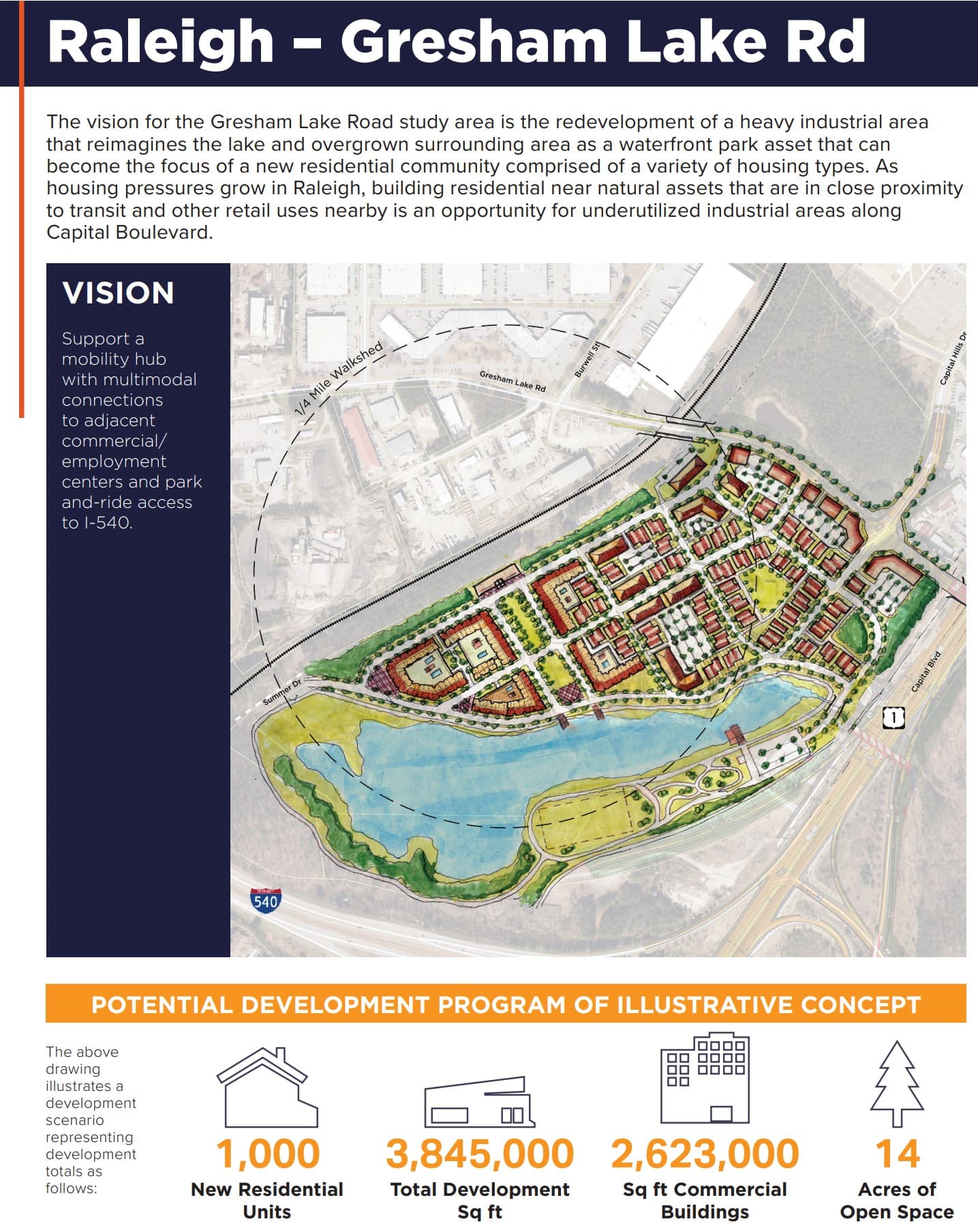
But regardless of that, the render of Midtown looks nice. Much better use of that land than car dealerships. I also really like the Old Forestville vision. It integrates with the surrounding development very well and provides the town center that Forestville lacks.
I wish they had done more with the Spring Forest area. It looks like there’s too much empty space for the exactly the type of place we need to fix.
The redevelopment of industrial areas is also kind of concerning. It may be considered “underutilized,” but concrete and stone suppliers, truck rentals, and whatever else are necessary. And the farther they get pushed out, the harder it is to build the stuff we want. But I’m just throwing my thoughts out here, I don’t really know how all of that works. Maybe it’s fine?
The study overall looks like a good vision, I wish the planners had a bigger role in implementing them directly. All they can really do is recommend policy and hope the municipalities play ball. If they could actually put in some development requirements, then we might actually get something that looks like the intended vision.
Quick question: I keep seeing on maps that NC is to acquire the S-Line all the way down from Hamlet, but have not heard any mention of it in the grants they currently have to purchase the Raleigh to Norlina section. Can anyone expand on that?
Not all of these sites will be SEHSR stations. Stations for that service will be at RUS, Wake Forest, and Henderson. There’s a proposal somewhere out there for regional rail on the S-Line that has station locations that coincide with these study areas.
If my memory serves me well, I don’t think they’re planning to buy the Cary to Hamlet section of the S-Line at this time. It will still belong to CSX. That said, traffic seems to be pretty light on this corridor, and there’s already a little bit of Amtrak service as well. I think the goal, for now, is to coordinate with CSX and do what they can. The only reason they were able to get the Raleigh to Norlina segment is that CSX barely uses it and didn’t have any qualms over letting it go.
My understanding is that there is a great deal more traffic on the S-line south of Bonsal (basically, the Wake/Chatham County line) than there is to the north of there. It seems like there are literally zero active customers on the S-line between Bonsal and Fetner (the junction with the NCRR in Cary).
CSX was recently considering building a new rail yard in the Sanford area, but they officially called off those plans in February. I do not know what this means but one possible explanation is that they are gearing up to sell it.
One question that comes up, but I have never seen discussed anywhere, is the disposition of the old Durham & Southern line from Durham to Apex. As far as I can tell, there are just four active customers left on this 18+ mile line, and only one (a building supply company) in the entire southern half. Definitely wouldn’t make sense for CSX to sell the S-line but hold on to the D&S.
Dang, the already-abandoneded stretch south of Apex would’ve made for an amazing rail-trail – through downtown Apex, Holly Springs, Fuquay-Varina, and Angier.
The stretch that’s still extant is… fine, I guess. Passes through the dense sprawl of west Cary and south Durham, and hugs the west edge of RTP, but besides Park West Village and the future Apple campus there’s nothing of note right next to it. Tough to imagine what mode it could be repurposed for. In a world where transit costs were normal, it could be a greenfield transit corridor funded by TIF-ing the vacant land along it, but… that’s not 21st C America.
Surprising in retrospect to think that Durham was important enough to require two parallel freight lines to the south (this and the American Tobacco Trail).
Not sure if this has been shared already/been noticed yet, but it looks like NCDOT recently(?) submitted an application for the DOT’s Reconnecting Communities and Neighborhoods program. This is for their Mobility Hub plan which includes regional/intercity rail stations and TOD in numerous communities surrounding and in the Triangle, including Apex and RTP. The timeline is pretty aggressive as the funds expire in 2026. The report also indicates that the rail portion of the new RTC is shovel-ready. I think this is further evidence of my hypothesis that we will get an NCDOT-lead regional rail before GoTriangle (but, importantly, some of this infrastructure will be shared!).
Decisions on grants will be announced in spring 2024. I wonder what our chances are here. Also curious about any thoughts from @orulz and @keita.