has there ever been studies showing traffic/commuting flow that originates inside the beltline to places outside the beltline? any regular established patterns? thx
I will say that during non-Covid times there’s quite a bit of traffic traveling Wade Ave. heading west in the mornings toward RTP.
3 Likes
Regional transit corridor studies could be a good place to start. A lot of times, they’ll have commuting pattern data even for people who don’t use public transit.
The RTA’s FAST study update from last November has this map, for example, that shows projected regional travel patterns to/from key “activity zones” like WakeMed or downtown Raleigh.

…so Raleigh as a whole (especially downtown) is pretty noisy compared to Chapel Hill or Durham, but you can see some ITB markers that are labeled for RTP, RDU, and even UNC.
7 Likes
Two thoughts: the official local travel demand models would be able to simulate that information, but it’s not usually reported as such.
https://www.campo-nc.us/mapsdata/triangle-regional-model/trm-information
For commuting flows specifically, this Census tool maps home and work locations:
https://onthemap.ces.census.gov/
2 Likes
Thanks for posting! Out of curiosity, Does CAMPO not employ full-time data scientists? It feels really strange (if not outdated) to me that the Triangle Regional Model is only updated like every five years, and you can only download it as a ZIP folder of shapefiles rather than having something more user-friendly like a web portal and an API.
Anyways, because I highly doubt most people here will actually do the work,I played around with the Census Bureau’s OnTheMap tool (the 2nd link Payton posted). Here’s a map of top 50 census tracts where ITB residents work as of 2018:

…and this is a map of the same for where ITB employees live:
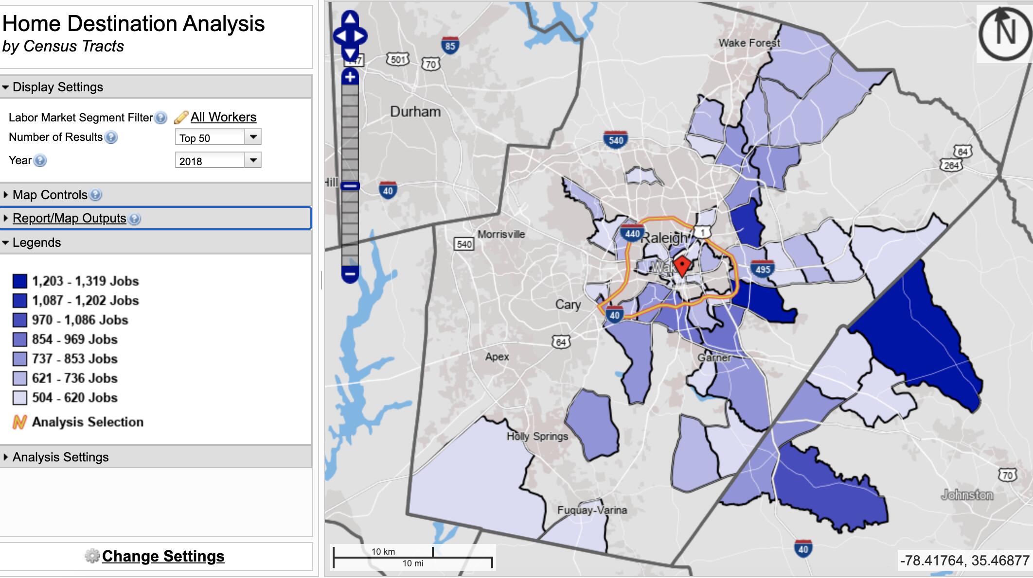
Remember, though: this only shows commute patterns! This doesn’t say anything about “third places”, or where you spend your time when you aren’t at home or at work (like where you shop, hang out with friends, go to church etc.). It seems like planners have only recently started to seriously study how people make those sorts of spaces parts of their lives.
6 Likes
The census data contains some odd artifacts that IMO lessen its value as a data set for analysis at this level of granularity, especially when it comes to job locations. I have long been suspicious that every state employee is listed as working at the state payroll office, which is in some nondescript location near Tarheel Drive just OTB. That would be the dark purple blob to the northeast of 440 on the first map (jobs) posted above
2 Likes
if im reading this right, johnston county and wake forest area create the line of incoming cars in the morning and the outflow at 5pm or so?
Streetlight data is great for stuff like this, but you have to have a membership / engineering project justification.
Streetlight is great - not 100% accurate (they take samples of bluetooth data) but from a high level, planning level viewpoint, it’s a pretty useful tool (though hopefully it’s improved since I last used it in 2018)
1 Like
I’ve been using it for a big study in Atlanta and they’ve made huge validation strides in the past couple of years. We compared it last year with our actual volume counts and most locations were now within 90-95%
3 Likes
Might be the best place for this. Would anyone have some archive traffic maps from Google or anywhere from rush hours pre-covid? Trying to see how me and my fiancé’s commutes will be if office life returns.
Don’t have any maps. Where is your commute to/from and we can probably give you an idea.
Wendell falls to Wade park
Truthfully, that’s a haul, and there will be some delays going from the Beltline to Wade Ave. The good news though is that you can stay all the way to the right on Wade Ave, since that becomes the exit to get to Wade Park. Travel time is going to matter as well.
The unknown is just how much post pandemic reduction in commuters to RTP to expect, because they are the ones that cause all the traffic.
2 Likes
Haul as in ~30 mins? Or hour plus? I’m from Atlanta so I’m used to everything being an hour plus
I am no expert on a commute from the east side to the west side of Raleigh, but I have a hard time believing it’s an hour. I’d believe 45 minutes every day of the week though if it’s rush hour.
2 Likes
What part of ATL where you from? I moved here from Atlanta in 2012 (GT IE 2009). Something I have found really different about this area is how many people actually live in the Raleigh city limits vs. ATL where most people do not. And, the county school system that you can’t just jump from easily. Oh yeah, and there was never a giant highway that tore through downtown here which is really nice.
2 Likes
Lived in southwest Atlanta for a year and Douglasville for 15 years before that
2 Likes
I’ll take it. I’m no stranger to longggg commutes. I likely won’t need to go to the office much, even after covid
1 Like
Not sure about coming in from Wendell. My commute is from North hills to RTP. A lot of it depends on timing. Pre-covid, I would leave the house at 6:30 to be at work at 7:00, and in the afternoons try to leave around 4-4:30 to beat the worst of the traffic. If it get’s much later then that I-40 becomes a real slog. But compared to ATL, probably pale in comparison (though it’s been a while since I have driven around Atl.
I-440 at Wade always backs up during rush hour. And they are re-doing that entire interchange now. Probably good timing to get the bulk of the construction done during covid, or that would be even worse right now. That should be improved once it’s all done.
It really depends on timing. If you can be flexible in the hours, and can avoid the peak times, I think you would be fine.
2 Likes