IMO, the retail space in the L Building is doomed until there is more around it than surface parking lots… I only see the L when I am driving through DTR heading north on McDowell. Currently it would be a tough location to establish a profitable business, but if the dual branded hotel at Davie/McDowell, and maybe a residential building on the same block (b/w the hotel and Nash Square) were built, I think store owners in the L would have a lot more customers. Right now they are in a void in that part of town.
The L was always a waste of property, Empire group should NEVER be allowed to build new, they are clueless with new structures, BTW - EMPIRE, SELL THAT PROPERTY next to circular hotel to a real developer.
The design of the L building, on a signature piece of property, is a waste valuable land, city council needs to stop these structures from being built in OUR downtown, there is nothing urban about the L.
And, was at Raleigh Times for first time in years, small portions and over priced for average quality, no more.
It’s already happened! Alamo Drafthouse in Longview, for example.
1 Like
The L currently has two retail shops that I believe have been open for more than a year. Maybe two. I’m not sure it’s that far off from the core but it’s certainly not ideal.
You see large spaces struggling or never get filled which is what I think is happening with the larger space in The L.
The former Krav Maga space on Hargett was split in half to two retail shops.
Devolve Moto was probably too big.
The guy seems to be really trying to make the large space at 222 Glenwood work (former Indio then a Thai place now seafood cajun place) but it keeps turning over.
The large retail spaces in the Citrix deck never happened. They took it over just like red hat is doing in their building.
I feel like the large space on Fayetteville street, where Pizza la Stella is, has had its turnover drama but being on the main street helps.
510 Glenwood kind of has the same problem with large spaces.
Relating it back to the topic, if people can’t make it work then they’ll move just outside where they can and rely on parking to attract the masses. That may change the perception of what is and isn’t downtown.
1 Like
But Dix Park is the largest and most anticipated urban park project in the country right now. Your coverage of it, although certainly more work for you, would give people here awareness of what’s being discussed there. Did you attend the latest public meeting? Check out the presentation here if you haven’t already:
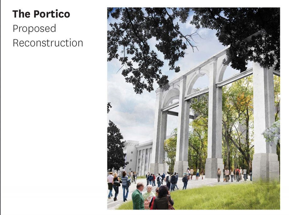
Land has been identified along Lake Wheeler Rd. for future building development within the park, and recommendations have been made for building rehabilitation vs. demolition with proposed uses including the asylum being converted into a boutique hotel, food halls, concert halls, etc. etc… Check out the concept for the hilltop where the historic hospital was built, and sadly demolished in the 1950’s. The image here portrays a reconstruction of the original 1850’s portico looking directly at DTR.
As a downtown lover, and SW Raleigh resident, I am so excited for this project!
5 Likes
Not to get too personal here, but I had a family member at the Dix Hospital back in the 1950s and 1960s. I love the green space at the property, but I would rather see all the buildings gone and make it a huge green park. Seeing the buildings (especially the one for the “criminally insane” with razor wire) only brings bad thoughts of what my family member went through during their time here. I have a hard time seeing positive here, and only feel the sadness and pain of those who were here either voluntarily or involuntarily. Just my personal opinion.
My boundary includes no single family neighborhoods.
Peace-Person-South-NCRR-St. Mary’s.
Nickster, I apologize for bringing up any painful memories. For you and many, many others Dix Hill will always be an asylum where bad things happened. And Leo, I apologize for going on a tangent here.
I must add the design team, informed via public input groups like the one I’m in and the city’s park dept., is very aware of the point that you’ve brought up, and they are doing important work in identifying some of the unmarked graves and unaccounted patients to help bring to light the history of the asylum’s patients and workers. Converting one of the buildings into a museum about the asylum is definitely on the table, which will help inform many people on the history of Dix hill, mental health, and the positive work that Dorothea Dix did in progressing the treatment of mental illness in the 19th century. (I understand her personal philosophy was not without moral blemish, however persuading the gov. to set aside pasture land for rehabilitation is a positive)
In the planning doc. linked above, it explains that the park must be financially self sufficient. This requires partnering with different organizations to utilize the buildings for revenue producing endeavors. Perhaps, and likely, one of those partners will be a mental health advocacy group fighting to further improve mental illness understanding and treatment. I hope you can view the Dix park project at minimum as a positive for the future of mental illness education and understanding, and for the future of Raleigh which is why we’re all here.
3 Likes
No need to apologize at all! To be completely honest, when it comes to Dix, this is a project I actually love being an avid follower and sideline cheerleader. Quite a few people I’ve talked to have asked if I wanted to get involved but I am choosing to kind of watch it evolve from the “nosebleeds.” I have so much faith that those behind it are going to do good by it.They got this!
I’ve chosen not to cover Dix on the blog, there’s plenty out there to consume about Dix and park design is just not my thing more than being that big cheerleader. A Dix thread on this community? Absolutely.
But is it in downtown Raleigh? I would elaborate on my earlier thoughts and say no but I am positive that over the next few decades we’ll see downtown grow towards Dix that maybe one day, it’ll feel differently.
3 Likes
For years I’ve been waiting for the downtown districts to fill in the spaces among the districts to create a more seamless DT experience. We are finally seeing this occur between Glenwood South and The Warehouse District and between Glenwood South and The Capital District with all of the new projects underway. Fayetteville and Moore Square have also seen a lot of connecting over the last few years with new public and private investment.
I think that we now have to think about connecting places like Dix Park to DT proper through a similar strategy. The energy and activity occurring along South Street is a good first step toward connecting DIX to the core of the city. The key , IMO, is to push that connection via investment & projects along the S. Saunders/Lake Wheeler wye because that connection doesn’t require pedestrians or bikes to cross the busy Western Blvd corridor. There’s plenty of room under the overpass to widen the sidewalk experience along S. Saunders, but a sidewalk must continue up Lake Wheeler to at least Black Rd., and along it into the park. I know that the Rocky Branch Trail already connects to the park, but I think we need a more urban approach as well to really connect it to DT.
Also, the triangle of land bounded by S. Saunders, Lake Wheeler and Hammell would seem to be key in establishing the urban connection of Dix to DT proper. I can imagine a sizable mixed use project on that land, but it would require a variance to go beyond its ix3 zoning. While ix allows for mixed use, it’s vague to me how much housing could be there. I like the idea of ix for that area though as it would allow for a working “crafts” community where custom carpenters, metal workers, etc. can make and sell their goods. Imagine a craft community there, along with craft breweries, parkside dining establishments, and co-living residences for the artists and craftspeople. The nature of the land itself ascending up Lake Wheeler would offer all sorts of interesting opportunities for rooftop placemaking with DT views. It would also be a really nice anchor for expanding the DT footprint with a purpose.
5 Likes
Between Dix Park, the decommissioning of the former Cargill plant, the commuter rail, the City Gateway project, etc., the whole area bounded by Lake Wheeler Rd., MLK Blvd., Garner Rd. and I-40/440 is going to be very, very prime area for development over the next decade.
For the most part, I find that prospect very exciting. A ton of new housing will be built there, businesses will move in, and it should accelerate the decommissioning of Raleigh’s two prisons, freeing up that land for more productive uses. But I do worry intensely about how the increasing desirability of that area could end up displacing long-term, lower-income residents.
The other interesting challenge relates to I-40/440. Raleigh has had good fortune in that it’s one of the few major metro areas in the U.S. that doesn’t have a U.S. highway running through it like a nasty scar, cutting neighborhoods off from each other. (There’s Capital Blvd./US 401 in places, but it’s surface streets through the downtown core.) Having a highway that runs just to the south, and a loop around the city, has served us well. But as density creeps further south, we’re going to have to find ways to build an cohesive community around one of those scars.)
6 Likes
Decades and decades ago, DT residents (mostly Oakwood) successfully fought the state and prevented a north/south freeway from plowing through the city center. The 401 corridor moving through the city as a couplet (one north/one south), with timed lights to keep the traffic moving, was the compromise reached to manage the traffic. I’d presume that those involved in this compromised presumed that traffic would move faster to both the north and south of the core. The challenge for the city is to figure out how to slow down the traffic in these 45MPH zones. It will take more than just signs as well.
I’m trying to remember if we talked about this or not in the past, but I’d love to see a large round-a-bout where S. Saunders, Dawson and McDowell come together. I think that we have talked about this; I just don’t remember when.
I’d also like to see one at Maywood to further calm the traffic through the southern gateway corridor.
3 Likes
David - I’ve been thinking about the last challenge you mention re I-40/440. My reasons are selfish because I live just south of 40/440, about 2 miles from the farmer’s market and 2.5 from Dix. We’re closer to downtown than many locations that are ITB, but accessing all those amenities essentially requires a trip in the car because we have to cross the asphalt moat, or scar as you put it, that is I-40/440. Getting in the car so I can do something 2 miles from my house doesn’t have a lot of appeal.
I believe someone else here brought up the idea of converting the railroad tracks that run through Dix, the Farmer’s market, and points south into a bike/pedestrian trail. I realize that’s a long shot, but it would give residents of Renaissance Park, Carolina Pines, and Fairway Acres neighborhoods an alternative way to access the area you describe. It also would connect to the existing Walnut Creek greenway. Another nice thing about this approach is that a non-automobile bridge is already in place.
Again, I realize this is a long shot. Maybe there are examples from other cities that we could draw on/learn from as to how to connect people across these scars?
5 Likes
Are those active rail lines or defunct? If defunct, that’s a great idea.
I didn’t come up with the idea, but I certainly like it. I thought I saw it mentioned here or on the Raleigh Connoisseur. Maybe in the comments section somewhere.
I believe the tracks are owned by Norfolk Southern and they are technically active as freight routes from what I can gather at this site:
Looks like that line runs out of Raleigh, splits somewhere around Fuquay and then one leg goes to Fayetteville and the other to Greensboro. I don’t hear trains running here very often but I have no idea how much freight goes into or out of downtown by train.
The same tracks also border Boylan Heights and Central Prison. They cross Western Blvd at Dix and could also connect to the Rocky Branch greenway.
I would think the land would be more valuable to the city as greenway than as a freight corridor, but who knows.
1 Like
+1 on the traffic circle at S. Saunders/Dawson/McDowell. There could be a triumphal arch style monument in the center as sort of the “Gateway to Downtown” from the south.
1 Like
@Brian I couldn’t have said it better myself. Turning that railroad into a greenway is a passion project of mine!
The line is active (I actually heard a train passing by this morning), but it’s not highly used. A handful of trains pass by each day, and it’s exclusively freight travel. Norfolk Southern is very adamant right now that they want to keep using that line for freight.
There are a few things that I think would strengthen the case for making that into a greenway. First is the completion of Dix Park, which is already happening. Second, the track runs through the land on which Central Prison sits. If Central Prison were de-commissioned (another passion project of mine!), the greenway could run through Dix Park and over Western Boulevard. At that point you hit the train tracks that will handle the commuter rail, but if the greenway then tuned west, it could parallel the tracks for a few hundred yards and end at Pullen Park, thus connecting Dix and Pullen. (And, yes, it would connect with the Walnut Creek Greenway, which would be a very nice perk!)
The rail line runs to downtown Fuquay-Varina before meeting up with other lines, so downtown FV would be the southern terminus of the greenway, and a delightful one at that. Right now this is something that is almost certainly at least a decade or more away, but it’s something that absolutely should be part of the long-term planning for this region.
4 Likes
I think a greenway down that rail line would be a great asset. Not just for Raleigh, but for the region. It could be used to connect to greenways in Garner or Fuquay-Varina, and become sort of a bicycle highway.
But really, even without this trail, Raleigh already has a VERY strong park system on the southern side of the city. There are a lot of parks and trails along the Walnut Creek. I’ve mapped out most of them here, which shows you how much we already have. I think that increased connectivity between these parks and more greenways is the most feasible next step.
4 Likes
People treat S Saunders and Wilmington St as freeways into downtown. People regularly travel 60+ down those barren stretches just outside DTR. I consider them to be just as scarring as any urban interstate.
2 Likes
I would even extend that area down to Tryon. In the Southern Gateway study, the Wilmington/Rush intersection (just west of Hertford Village, where the Blue Martini etc. are located) and that shopping center just east of Renaissance Park are meant to have new town centers (i.e. Transit-oriented, mixed-use developments).
I completely expect that MLK and 440 will serve as dividing lines between two brand new “areas” of the city. Someone will come up with catchy names for both that no one likes at first but the developers and real estate agents keeps using, and eventually there will be so many new residents who only know it by those names that they’ll just stick. Honestly, knitting together areas with a common identity (instead of saying “the area between x, y and z streets”) will be a positive thing, even if/when the names are super lame.