I can’t remember where I first read the scar analogy (I certainly didn’t think of it), but it was in reference to the fact that a lot of the highways that now run through major cities were built by razing existing communities whose residents were overwhelmingly poor and people of color. In fact, bulldozing those communities was seen by white, wealthy planners as a desirable thing in its own right. This isn’t the story where I saw the analogy, but it’s a good history: Highways gutted American cities. So why did they build them? - Vox
Luckily, Raleigh was spared the worst of that. But, yes, having lanes and lanes of concrete whisking cars through your neighborhood at high speeds is definitely scarring in its own right!
Completely agree with you, and that’s why I want to see something really big happen at the Cargill site along Wilmington. That’s a big opportunity to humanize that stretch of roadway.
I’ll say that the city has proven to me that it’s committed to fulfilling the northern boundary of the city proper to up through the Devereaux Meadows/West St. tentacle, and toward the northeastern edge of Dix Park with the development @ The Weld.
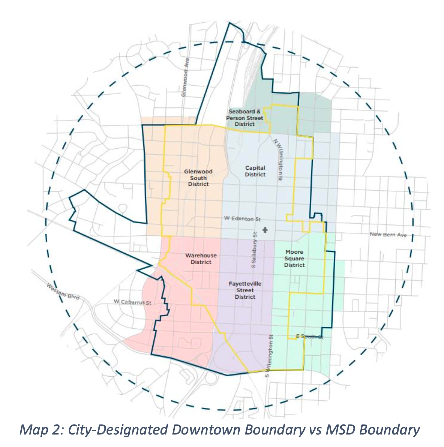
This is the map from a 2024 Downtown Raleigh Alliance study on the expansion of the MSD Boundary.
It seems to me that the official boundary should expand to the southwest to meet Dix Park, and to the northeast into the Person St. District. The Downtown Raleigh Alliance calls the area to the southwest “Dix Edge”. For me, this expansion is a no brainer as dense development pushes toward the park.
The North Person area is currently not in the official downtown boundary despite it having more legacy urban credentials than the rapidly growing Seaboard Station that’s already included in the downtown boundary. For me, including N. Person is a no brainer.
That certainly makes sense to me. Both areas are more than downtown adjacent in my mind. Enlarging the area is also good pr, expanding in peoples minds what downtown means. You cant feel downtown is x y or z if you are at Dix every other weekend.
Expansion does make me wonder if and when the area expands to the Village, (nee Cameron)?
I have a difficult time imagining the inclusion of the Village District due to the blocking effects of Forest Park (Cameron Park), Glenwood-Brooklyn, and Broughton High School. While certainly close enough to downtown proper, and having urban credentials of its own, I don’t see the Village District operating as an exclave of downtown, and I don’t see the city pushing its downtown boundary through these single family neighborhoods. What I can imagine is the strengthening of the connection between the university and the Village District: creating a more robust urban neighborhood within the city that can better stand on its own. It’s really not far off from that now.
Maybe the city will prove me wrong and claim the entire west side through to NC State as part of downtown?
Relatively new in Raleigh, but my mental map aligns closely with R-Dub’s post from 2018:
Peace to the north
Person to the east
St Mary’s to the west
MLK to the south
Once Smoky Hollow Park is underway, I think the entirety of West St will be considered downtown, with the exception of the section in Boylan Heights. The West St tunnel would go a long way to making that section south of the train tracks feel more like downtown. There’s currently some density there, but it feels disconnected from downtown.
As far as Dix is concerned, there would need to be some major changes around MLK to make Dix feel like it’s downtown. To me, one of the main characteristics of a downtown is the connected street grid. MLK completely disrupts the grid in that part of town, providing limited options for pedestrians to cross. I know the Chavis-Dix Strollway is planned, but still, that’s only a single connection.
I think that most people would agree with this “square” represents the core of downtown, but there are areas that extend beyond it that are already officially considered within the downtown boundary. This mostly occurs to the north of Peace and west of St. Mary’s.
As someone who lives in the Village District it seems more “downtown proximate” than actually downtown. I even say “I’m going downtown” when heading there.
Have an excellent view of the skyline from our balcony. Watched (and heard) the fireworks. Can even hear Red Hat acts.
Downtown feels close. Just a short bus ride away and I have even walked home from the west side. But doesn’t feel downtown like the years living at Skyhouse felt.
Do like the idea of strengthening east-west (Peace?) and north-south (Oberlin?) connections that are bike/ped friendly.
When I walk to the Village District from Glenwood South, I always take the route through Forest Park on Johnson Street. I’d do the same by bike and follow the flat creek bed. It’s that section through Forest Park that causes me to agree with you that the Village District is downtown proximate.
I think “downtown” will always be the area between the historic districts. As long as we value neighborhoods and as long people keep trying to make an area its own district, downtown will be just that but we’ll also have these districts and neighborhoods to also enjoy.
What could elevate it all is if there are reasons to go and spend time in each district/neighborhood. Each one needs some eats and drinks but also some things to do that can’t be done in other districts. Residents in each one should give it their own flavor so that visitors actually feel like they are in that place.
If it’s all stitched together with low-speed streets, good bike lanes, and nice sidewalks you could maybe call it all downtown, at least to visitors but I never think locals will accept it.
I have vision that over time what is considered “downtown” and who is considered “local” will change “with time” as it always does. Change is inevitable. I am always hopeful that “the change” can move in a beneficial and positive direction.
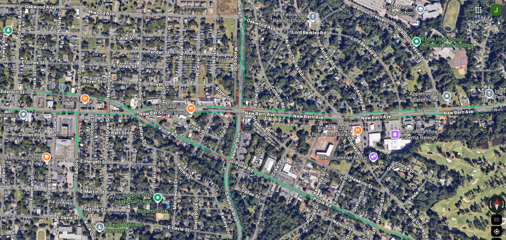
FWIW, I live near Wake Med and when I drive down New Bern, I pretty much consider myself “arrived” in downtown when I pass Raleigh Blvd. I know that’s a much more liberal definition than the above maps but you automatically can tell it’s more of an urban style area when you hit that point.
The BRT certainly has the ability to pull downtown eastward, especially around the bus stops if developed more densely. That said, Raleigh Blvd is a line in the sand of sorts where the older grid yields to more suburban land use models. This is really evident if one looks at satellite view on Google Maps.
Here’s something fun for Fun Friday. Go to this tool and “draw” on a map what you consider to be downtown. After submitting your results, you’ll get to see what others thought as well by overlaying everyone’s results against yours. It’s pretty interesting.
Oh, that’s lots of fun!
It would be awesome to understand peoples’ perceptions based on where they live. In other words, do people who live in far north Raleigh perceive downtown differently than people ITB, or actually downtown?
North Raleigh isn’t monolithic, so it shouldn’t be a surprise that there are diverse views of DTR. Some people work in DTR. A few transit DTR on the way to their jobs. Some attend NCSU, Peace, etc. Some children and teens attend magnet schools in the DTR vicinity (mine did). Some people visit DTR for dining or entertainment Friday-Sunday but seldom go there at other times except for government business (e.g. court dates, not a happy trip). Some attend churches DTR. Some work in RTP and find the commute far easier than in California, Atlanta, etc; they see DTR as a curiosity or an accident of history that’s not relevant to them. Some people do not go to DTR at all, and the more they read about crime they more determined they are never to go. Some love to see high-rise development in DTR because it keeps as many high-rises out of north Raleigh as possible. Some voted for the transit tax and see a vibrant DTR as necessary for the city’s overall well-being and quality of life. Others see DTR as a bottomless sinkhole of tax dollars that benefits a small number of people (e.g. the Convention Center) and would be happy to see the City split into two cities along I-440.